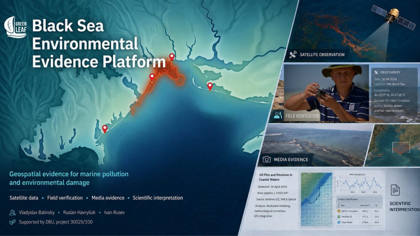
The interactive Black Sea pollution map combines satellite data, field observations, laboratory material and verified sources. It supports the documentation of environmental damage caused by russia’s aggression against Ukraine.
How to use the map. Open the layer catalogue, select an event or evidence type, and click a point, line or polygon. The object card provides the date, coordinates, observation method, photographs, sources and scientific cautions. Open the map full screen.
This platform was not created for neutral observation of the war. The russian federation is the aggressor state, and its full-scale invasion has caused extensive and long-term damage to Ukraine’s environment, including the marine and coastal ecosystems of the Black Sea.
The United Nations General Assembly formally defined russia’s actions as aggression against Ukraine. The UN Environment Programme also documents the war’s broad environmental consequences and their regional implications for the Black Sea.
Official Ukrainian assessments already measure damage to the Black Sea and Sea of Azov in the hundreds of billions of hryvnias. The real loss, however, is not limited to clean-up costs or damaged property. It includes habitat degradation, animal mortality and displacement, loss of ecosystem functions, persistent contamination, broken scientific time series and reduced capacity for recovery.
When an incident exists only as a news item, social-media post, photograph or satellite image, it can remain in the information space without becoming verifiable evidence. Investigation requires a date, coordinates, the original file, a named author or source, the acquisition method, links to related material and an honest statement of uncertainty.
This is why NGO Green Leaf, scientists from Tuzly Lagoons National Nature Park and project lead Ruslan Havryliuk developed a tool that brings these materials together in a single geospatial environment.
Each point, line or polygon opens not merely a symbol but an evidence card containing the date, coordinates, observation method, photographs, satellite material, sources, scientific interpretation and remaining uncertainty.
The platform is designed to preserve, verify and organise material that may be important for investigations of environmental crimes, possible war crimes, proceedings concerning ecocide under Ukrainian law, and future claims for compensation and reparations. The map does not issue legal judgments: legal qualification belongs to investigators, prosecutors, experts and courts. Our task is to prevent evidence from disappearing, preserve its provenance and make the verification method transparent.
The platform is not a complete register of every pollution event in the Black Sea. It includes incidents for which the team has sufficiently reliable satellite, field, laboratory or documentary material. The absence of an event from the map must not be interpreted as evidence that no pollution occurred.
Why the marine environment requires a dedicated evidence system
During war, the sea is one of the least accessible environments for regular scientific monitoring. The occupation of Crimea, hostilities, mine danger, attacks on ports and vessels, navigation restrictions and risks to research teams make the conventional model of systematic ship-based observation impossible across substantial parts of the marine area. Actual access changes with the security situation and cannot honestly be reduced to one stable percentage.
Under these conditions, open satellite data, field verification along accessible coastlines, laboratory analysis and secure preservation of media become core rather than supplementary tools. They make it possible to observe processes where a research vessel cannot safely operate, while also showing where remote interpretation requires field or laboratory confirmation.
Evidence for damage assessment and compensation
Documentation is directly connected to future compensation. Category B3.1 of the Register of Damage Caused by the Aggression of the russian federation Against Ukraine expressly covers environmental damage, monitoring and assessment costs, restoration measures and loss of intrinsic ecological value.
Evidence collected and organised today can therefore form an initial layer for future state claims for compensation and reparations. Formal submission will still require separate authentication and action by the competent authorities.
International scientific cooperation
The platform is also an appeal to the international scientific community. Ukrainian researchers need more than statements of solidarity: they need access to satellite archives and computing capacity, laboratory facilities, equipment, secure repositories, international expertise and support for safe field missions. Without such support, a substantial share of marine damage will remain undocumented.
From initial cases to a scalable system
The current edition grew out of the documentation of three events with different physical and ecological characteristics: the Volgoneft-212 and Volgoneft-239 tanker disaster and heavy-fuel-oil pollution; the vegetable-oil spill associated with the Port of Pivdennyi (VO-1); and the spill associated with the Port of Chornomorsk (VO-2).
These cases do not define the final boundaries of the project. They form the first fully developed test of a common approach that can be applied to new accidents, damaged vessels, consequences of Russian strikes on port and maritime infrastructure, affected habitats, animal mortality and other forms of environmental harm.
Every event uses the same internal logic:
- source and primary release;
- development and transport;
- field evidence and sampling;
- biological and habitat impacts;
- analytical reconstruction.
This structure reveals a complete causal chain rather than an isolated dark patch on a satellite image. It connects a probable source with immediate and delayed effects, including secondary accumulation of contaminants in bottom sediments and their later remobilisation into the water column and marine circulation.
This is especially important in the semi-enclosed Black Sea: the disappearance of a surface slick does not mean that the impact has ended. Basin-scale cyclonic circulation generally proceeds counterclockwise and can transport tracers between eastern and northwestern sectors, including towards the Odesa coast and the Danube Delta.
The actual pathway of each event nevertheless depends on wind, waves, mesoscale eddies, stratification and local currents. It must therefore be assessed event by event using satellite, field and modelling evidence: Black Sea circulation, variable Kerch Strait exchange, and post-depositional remobilisation.
The map is also a georeferenced media repository. Users can move from a mapped object to a photograph, a satellite crop, an analytical document or a public source. This is useful for scientists, protected-area staff, journalists, civil-society organisations, investigators and experts who need to understand not only what is shown, but what evidence supports the description.
How an evidence object is built
The principal unit of the platform is not the layer or the symbol, but the evidence object. It may be a field-observation point, the boundary of a satellite anomaly, an affected habitat, a sampling site, the position of a vessel fragment or a reconstructed transport line. Each card contains complete English and Ukrainian sections so that the material can support both national and international communication.
How to read the map geometry:
- Points mark observations, finds, sampling locations or probable sources.
- Lines show documented movement or cautiously framed analytical reconstructions.
- Polygons outline interpreted boundaries of satellite anomalies, contaminated areas or affected habitats.
The cards distinguish three levels. Direct observation is what is recorded in an image, in the field or in a document. Interpretation is the scientific explanation of that observation. Analytical reconstruction is the reconstruction of a probable source, pathway or relationship between separate observations. Keeping these levels separate reduces the risk that a working hypothesis will be read as a directly established fact.
Data provenance is preserved in the same way: photographer, institution providing field material, person responsible for samples, laboratory or media partner, and source of satellite data. A numerical laboratory value is not assigned to an individual point unless the sample identifier, location and date can be matched explicitly.
Satellite methodology and field verification
Radar and optical satellite data
The remote-sensing workflow integrates radar data from Sentinel-1 and optical imagery from Sentinel-2. Radar makes it possible to examine the sea surface independently of daylight and with substantial all-weather capability.
Surface films can damp short waves and produce dark anomalies in SAR imagery. Similar signatures may also be caused by low wind, natural surfactants, atmospheric processes or current boundaries. A dark area is therefore an analytical lead rather than automatic proof of pollution.
Sentinel-2 helps verify boundaries, colour and structure, and can reveal dense accumulations, emulsions and individual surface objects. Time-series analysis is combined with meteorological conditions, slick morphology and independent evidence. Where an underwater leak is suspected, backward tracing relates persistent dark-core zones to the direction of transport, water depth and the estimated rise of particles from the source to the surface.
The approach is described in the published paper Integrated methodology for tracing oil slicks using Sentinel-1 and Sentinel-2 data: backward modelling, meteorological correction, and visualization analysis, presented in the proceedings of the “Ecology. Human. Society” conference; DOI: 10.20535/EHS2710-3315.2025.332100.
Field verification
Satellite interpretation does not replace fieldwork. In Tuzly Lagoons National Nature Park, field verification is conducted by the Park’s Research Department under the scientific supervision of Ivan Rusev. It includes GPS positioning, photography, descriptions of substrates and habitat condition, biological observations and sample collection. Ruslan Havryliuk coordinates sample records, integration of laboratory data and scientific interpretation of analytical results.
Three current cases — the first operational edition
Volgoneft. This module combines accident and wreck locations, dated satellite observations, probable residual leak sources, drift reconstructions and M-series field points documenting heavy-fuel-oil contamination. A central task is to show where direct evidence ends and where the hypothesis of long-range transport toward the Odesa coast begins.
VO-1. The vegetable-oil spill associated with the Port of Pivdennyi demonstrates the temporal development of an industrial surface film and the way its visibility changes between radar and optical imagery.
VO-2. The event associated with the Port of Chornomorsk provides the most complete chain, from the port source and satellite dynamics to field and biological verification. It includes FP-1, FP-2 and FP-3, documented by Ivan Rusev and the Park’s Research Department: impact on a protected sandy barrier, a psammophilic habitat and vegetable-oil film or emulsion in coastal waters.
Together, these modules show that the same architecture can be used for different pollutants and evidence types. Future events will be added as new modules within the existing system rather than through the creation of a separate map from the beginning.
Media repository, data provenance and limits of inference
Photographs, satellite crops and documents are not treated as decorative illustrations. They remain linked to a specific place and statement. Media are attached to an existing evidence object when they describe the same spatial situation. A separate media point is created only when the material has independent spatial meaning.
M-series heavy-fuel-oil field photographs and materials are attributed to Vladyslav Balinsky and Ivan Rusev according to the current register. FP-1, FP-2 and FP-3 materials were provided by Ivan Rusev and Tuzly Lagoons National Nature Park. Analytical data associated with the M-6/M-7 survey were obtained within the work of the International Charitable Organization Environment–People–Law and provided to the project by Olena Kravchenko.
The platform is designed to preserve material that may be important for investigations of environmental crimes, possible war crimes, proceedings concerning ecocide, and claims for compensation and reparations. Publication on the map does not replace procedural authentication, a proper chain of custody, laboratory traceability, independent expert validation or a decision by a competent authority.
Who develops and maintains the platform
Vladyslav Balinsky — remote-sensing methodology; Sentinel-1 and Sentinel-2 processing and interpretation; scientific mapping; field verification; evidence-system architecture; and publication preparation; Research Department, Tuzly Lagoons National Nature Park.
Ruslan Havryliuk — project leadership; scientific coordination; sample and laboratory-data coordination; integration of analytical results; and scientific review.
Ivan Rusev — scientific supervision of field verification; biological and ecosystem interpretation; validation and provision of field materials from Tuzly Lagoons National Nature Park.
NGO Green Leaf is the project’s publication and media platform. Related institutional and project materials are published by the National Ecological Centre of Ukraine, including the SUNDANSE project page.
The platform is developed and implemented with support from the German Federal Environmental Foundation — Deutsche Bundesstiftung Umwelt (DBU), project 30025/100. The authors and partner organisations gratefully acknowledge DBU grant support. Scientific content, interpretations and conclusions remain the responsibility of the authors and participating organisations.
This work also has a personal dimension. In January 2026, the National Ecological Centre of Ukraine reported systematic persecution, in-absentia criminal proceedings and direct threats against Vladyslav Balinskyy connected with his role in documenting war crimes and acts of ecocide.
This is another reason why an evidence base must not depend on the safety of one person or remain in a private archive. It should be distributed, open to verification and institutionally protected.
How to use the map and what comes next
Open the layer catalogue, select an event and click an object. Its evidence card provides photographs, sources, documents, the observation method and limitations. Satellite and field polygons are scientific interpretations of spatial evidence rather than perfectly exact physical boundaries of pollution.
Submit material. Photographs and reports of heavy fuel oil, petroleum, vegetable oil, dead or affected dolphins, birds and other biota can be sent to zeleniy.list1@gmail.com. Please include the original photographs, date, location or coordinates and a short description. Do not place yourself at risk in order to document an event.
The public map is a viewing and verification interface. It does not replace protected storage of original files, the internal evidence register or a procedural chain of custody.
- For social media, press communication and general sharing, use the URL of this article.
- For full-screen analysis, use the direct uMap link.
- For scientific use, open the individual evidence card and review its sources and limitations.
- The platform will be expanded as new verified data and event modules become available.
Read the full scientific and methodological description
Language version: Читати українською.
Suggested citation: Balinsky, V.; Havryliuk, R.; Rusev, I. Environmental Evidence Platform: Interactive Map of Pollution and Damage to the Black Sea. NGO Green Leaf, 2026. The map is a living resource; an access date should be included when citing it.
An adapted institutional version of this publication is also available from the National Ecological Centre of Ukraine: “How Ukraine Is Documenting Environmental Damage to the Black Sea” .

The monitoring was carried out with the support of Deutsche Bundesstiftung Umwelt (DBU, German Federal Environmental Foundation) under its programme supporting Ukrainian researchers and conservation professionals. The content of this publication, the interpretation of the data and the conclusions are the responsibility of the authors and do not necessarily reflect the position of DBU.