The first month after the accident of the Volgoneft 212 and Volgoneft 239 tankers in the Black Sea, Russia spent exclusively on propaganda. No measures aimed at minimising the consequences of the disaster (isolation of the damaged tanks, pumping out fuel oil, organising booms) were taken for at least 28 days after the accident. These are the conclusions of the analysis of satellite images from the shipwreck sites.
The two wrecks of the Volgoneft 212 tanker drifted freely, spilling tonnes of fuel oil into the sea, at least until 12 January 2025. The accidental drift path during this time was at least 8.25 kilometres! It is impossible to carry out any work, especially diving, on objects that drift and change their spatial position.
Most of the Volgoneft 239 tanker (stern without bow) is on the shore, accessible to equipment, but despite serious fuel oil leaks, no work has been done to pump it out. To find out what was happening to the wreckage of the two smashed tankers, I used the capabilities of modern satellite technology.
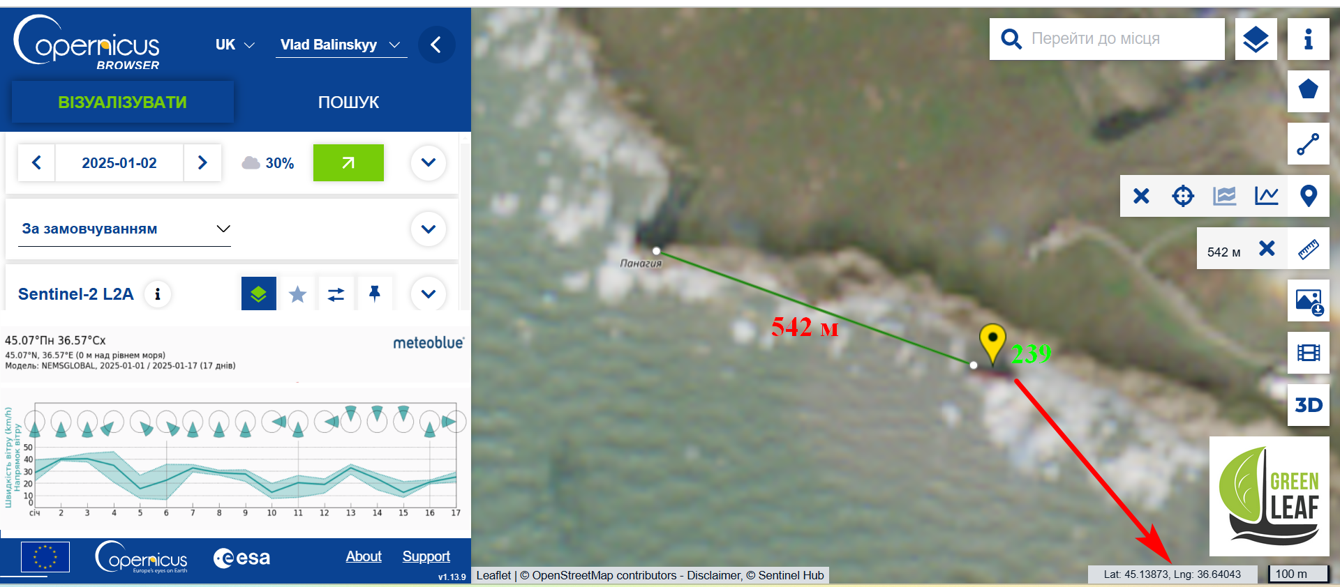
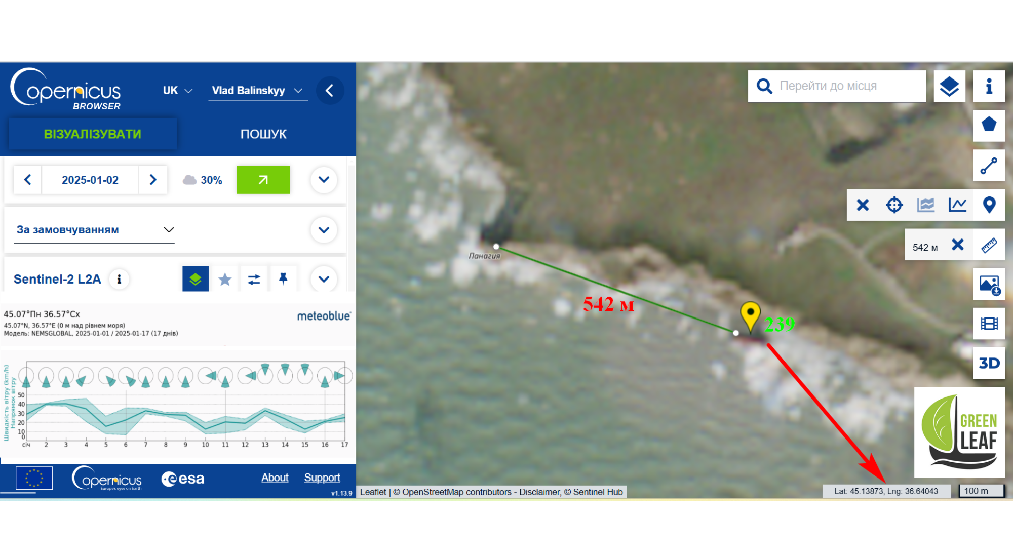
Volgoneft 239 wreckage coordinates
It all started with a logical and quite feasible task in the world of satellite technology – to determine the exact location of all parts of the wrecked vessels. In fact, it turned out to be more difficult than I thought. The stern of the 239 was the easiest part! The EO Browser and Copernicus Browser services provide enough tools for this task. I used satellite images from the Sentinel-2 L2 satellite.
Technical note: “Sentinel-2 provides high-resolution visible and infrared imagery for monitoring vegetation, soil and water surfaces, inland waterways and coastal areas. Spatial resolution: 10 m, 20 m and 60 m, depending on the wavelength (pixel size not less than 10 m). Shooting frequency: maximum 5 days”.
The most difficult thing in this case was to find images where the area of interest was not hidden under cloud cover. These are the coordinates: latitude 45.13873, longitude 36.64043.
I have read about promises from the Russian government that work on pumping out fuel oil will begin by the end of January, but I am sure that this will not happen. God willing, they will at least plug the holes with t-shirts and rags.
The second wreckage of the Volgoneft 239 (bow) does not pose a particular threat to the environment as it does not contain any residual fuel oil. Moreover, it is for this reason that its search proved technically unpromising.
Methodology for searching for the wreckage of the Volgoneft 212
Searching for objects underwater, even if they are very large, in the muddy waters of the Kerch Strait using only remote satellite sensing is a task of great difficulty. But I came up with an idea.
Sentinel-1 images are also available on the EO Browser and Copernicus Browse platforms. The Sentinel-1 method is based on the use of synthetic aperture radar (SAR), which allows to create images of objects, such as landscapes or water surfaces, with a pixel width of 10 m (IW) and 40 m (EW). The radar waves bounce off the water surface, either strengthening or weakening each other, depending on the phase ratio, which makes it possible to see the ripple and wave patterns on the water surface quite accurately. This method is called interferometry. Using interferometric data processing, it is possible to obtain highly accurate data on the position and size of spots of surface film pollutants.
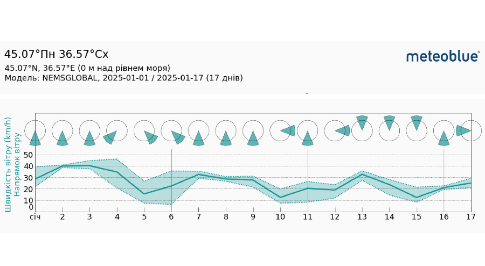
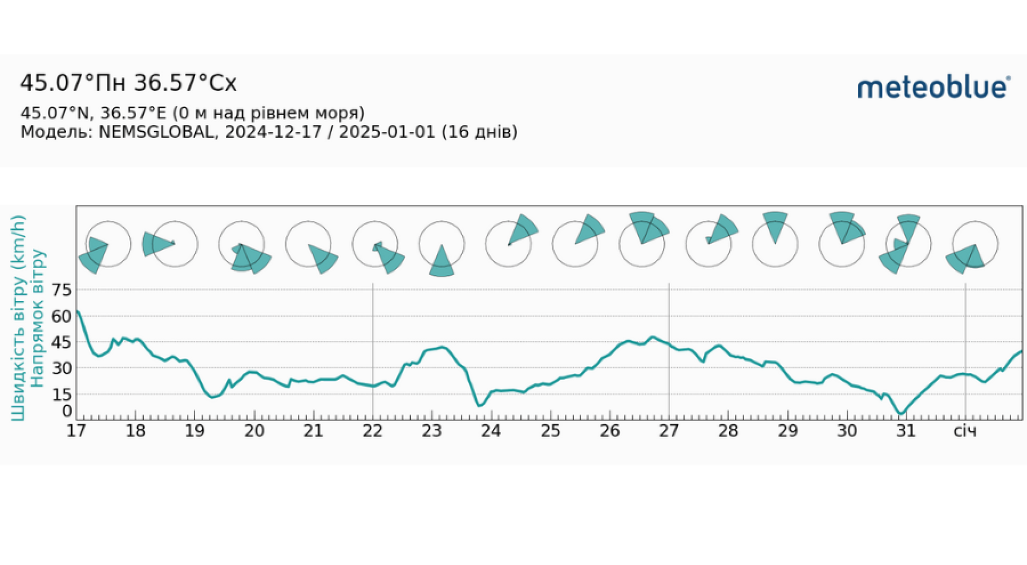
So my idea was to calculate the underwater position of the two wrecks of the Volgoneft 212 vessel by the fuel oil plume that should come to the surface and then spread along the wind vector. With images from different dates and with different wind directions, the underwater location can be calculated with an accuracy close to the satellite resolution (40 m). Also to analyse the wind direction and strength, it is important for us to have at hand the archived data of weather conditions at these coordinates for this period. Thanks to Windy.com’s Meteoblue service, this was not difficult, thank you!
Satellite data collection and analysis
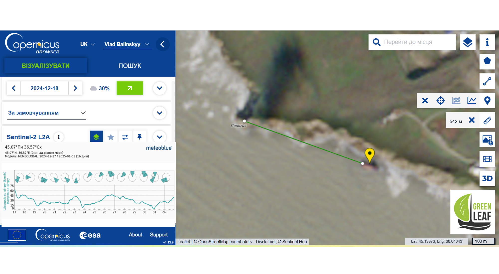
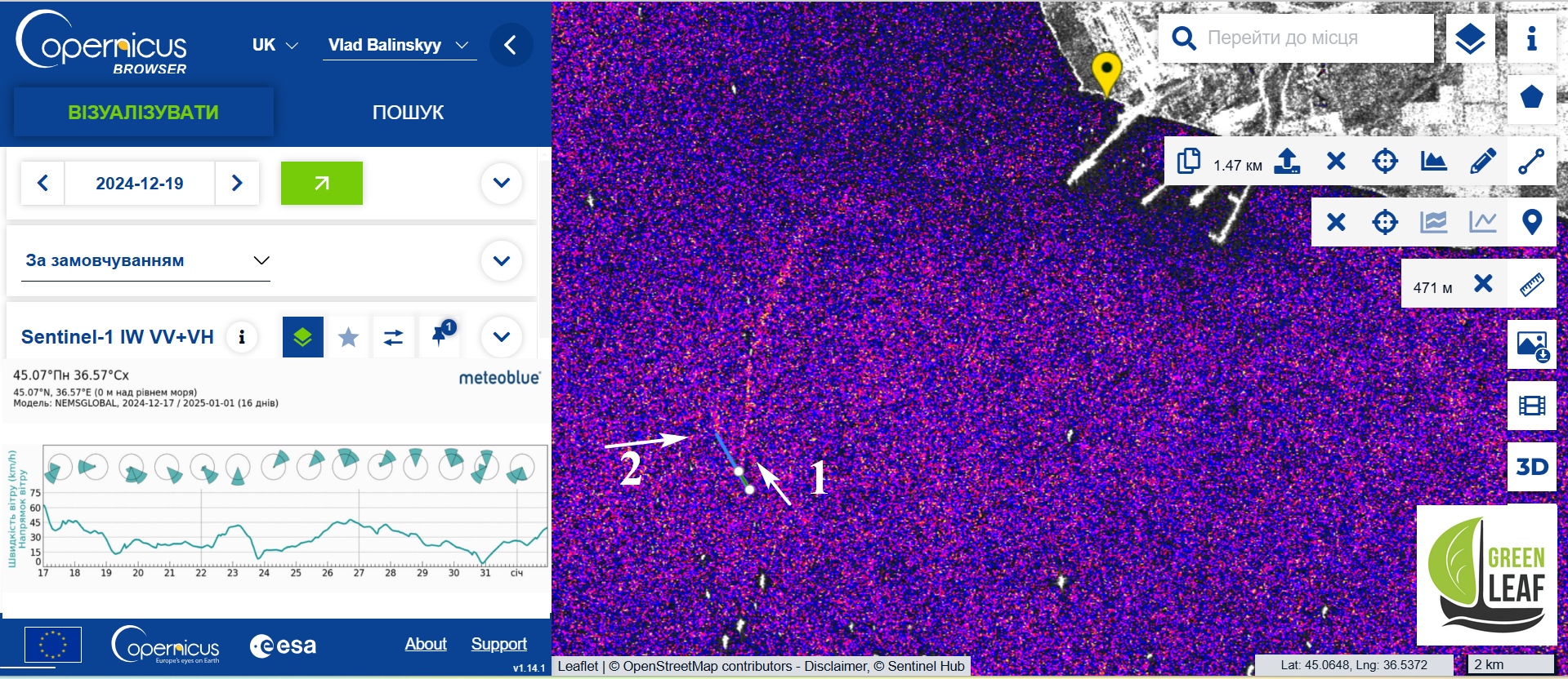
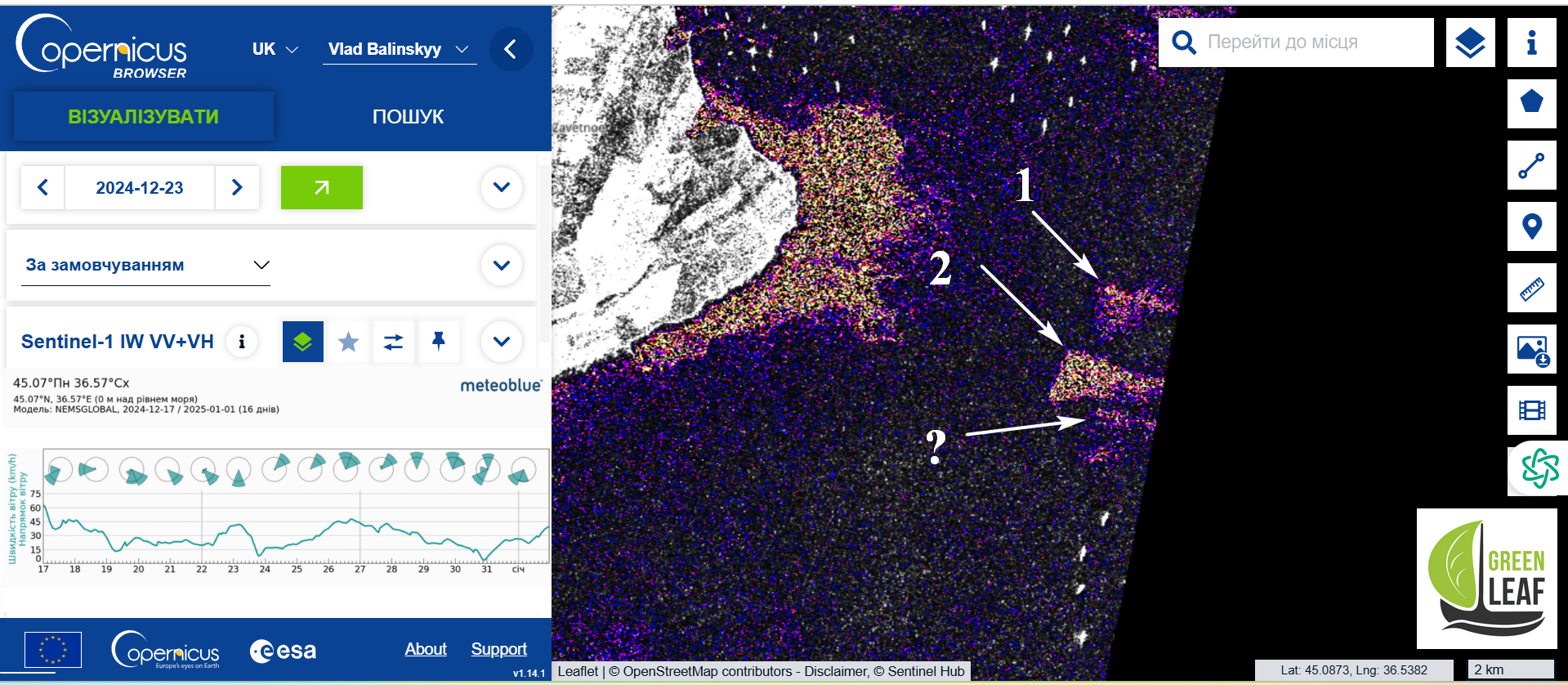
It immediately strikes the eye that there are not so many successful relevant shots from this period. But there are some! The first picture after the accident is dated 18.12.2024. That’s exactly what we need. We analyse the area at the exit from the Kerch Strait and find the following:
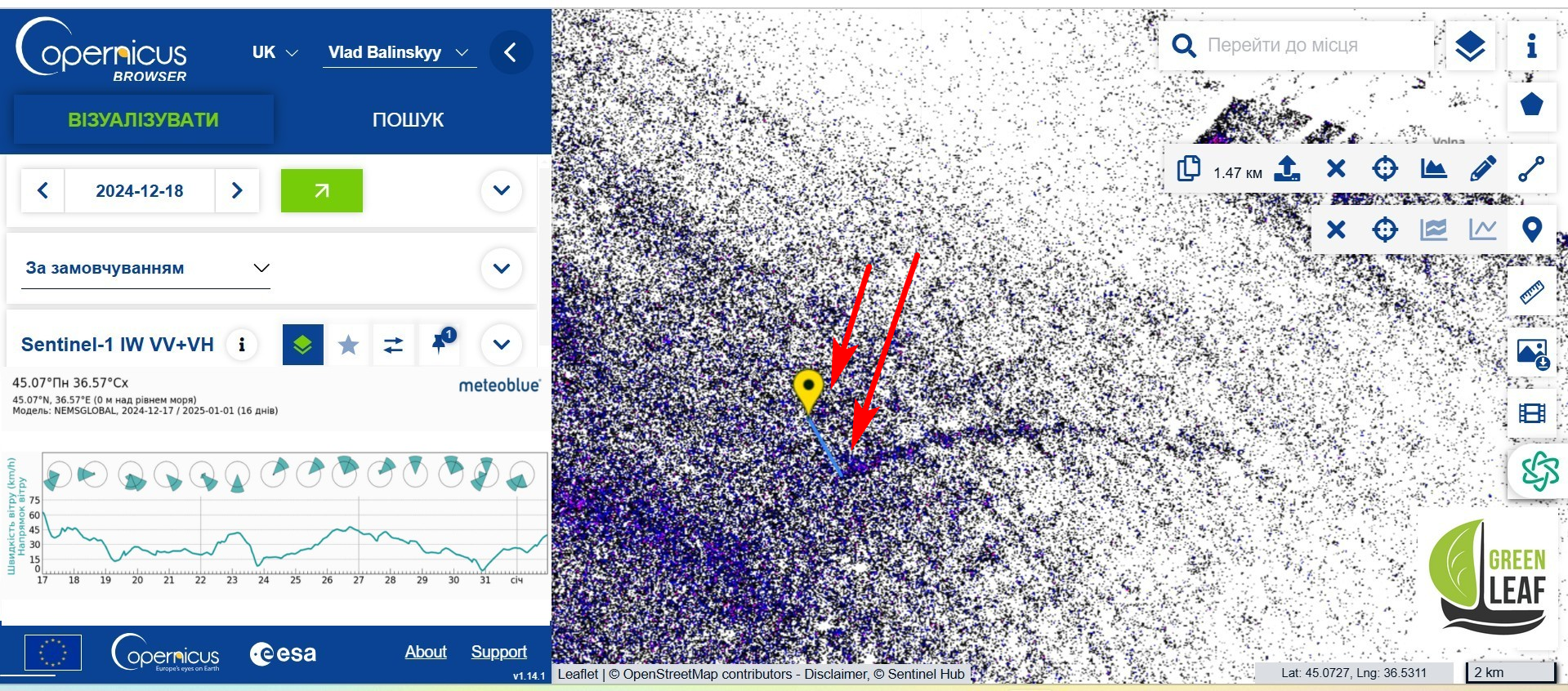
I would like to draw your attention to the fact that the image clearly shows two anomalies, the distribution of which corresponds to the wind direction and immediately stands out against the relatively homogeneous water pattern. It seems unlikely that two pieces of wreckage from the same vessel could be 1.47 kilometres apart. However, the wind map during the storm on 15.12 and the following day roughly corresponds to the direction of the segment between these anomalies.
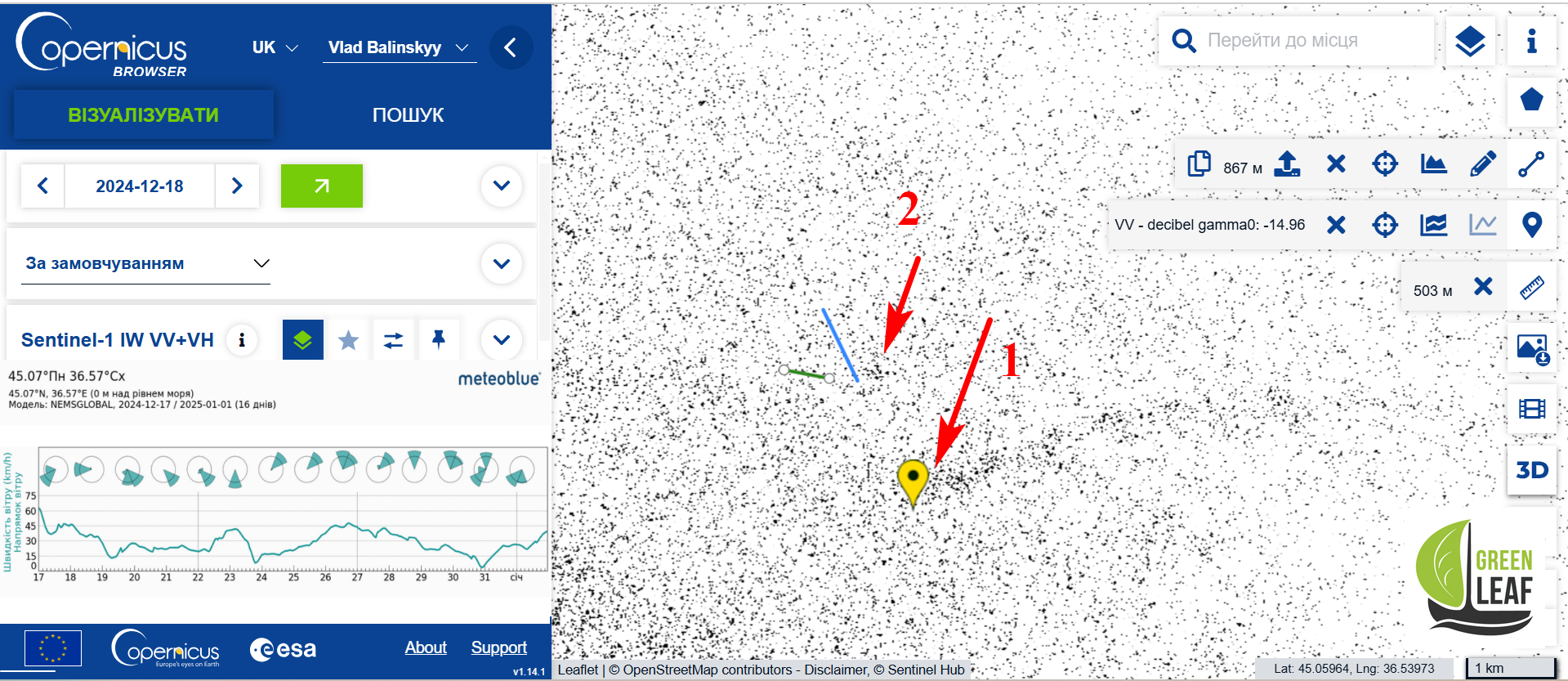
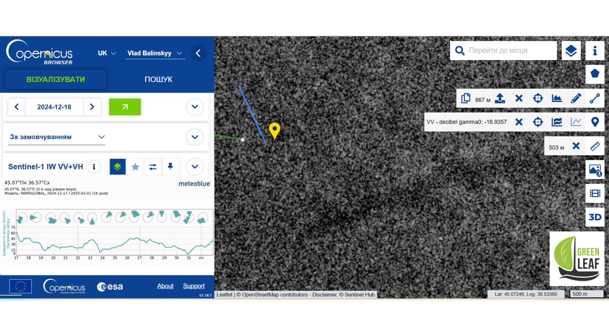
To determine the coordinates more accurately, we bring the object as close as possible and use various scripts to distinguish the useful signal from the noise. For convenience, we mark the objects as 1 and 2. Please note that as of 18.12, the fuel oil plume from object 2 is very weak.
Coordinates of the Volgoneft 212 tanker accident
To recreate the accident, we can assume that part of the 212-2 was super-heavy and sank first, while the lighter half of the 212-1 was carried by the storm into the wind for some time. Looking ahead, this assumption was confirmed by further data, and
This allows us to put the crash point of the Volgoneft 212 vessel on the map quite closely, 0.8 kilometres from the position of the 212-2 wreckage – here it is: latitude 45.07841, longitude 36.53440. However I emphasise that this point is very conditional!
Drift of the Volgoneft 212 wreckage
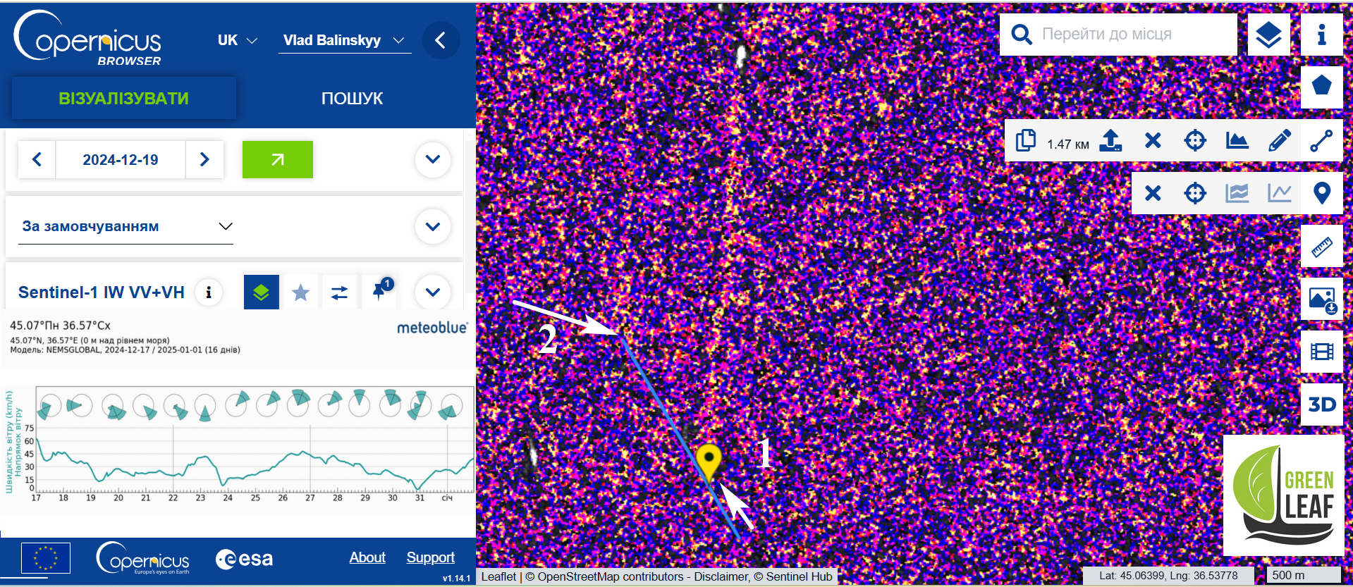
The next image is dated 19.12, and at this stage it is much easier for us, since the EO Browser and Copernicus Browser services allow us to link all marks on the images to coordinates. That is, the search area has already been narrowed down as much as possible, and, according to the plan, the plumes from all subsequent photos should converge to the tops of this blue segment in Photo 5.
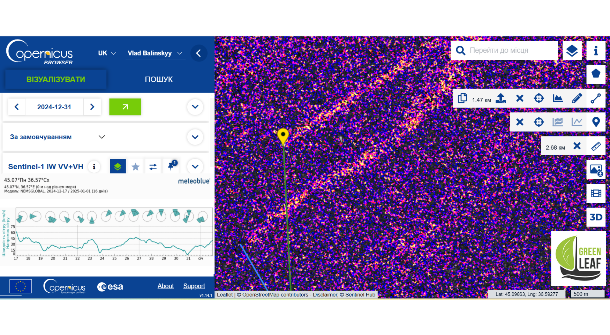
Look: a different date, a different wind direction, and our anomalies are still there. Well, almost there. Now we can say with more confidence that these are the halves of the Volgoneft 212. Please note that the direction of the plumes roughly corresponds to the strongly changed wind direction. Interestingly, while part of 212-2 moved slightly, half of 212-1 ran downwind for 471 metres, as if wanting to reunite. Yes, it seems to like to go for a walk, which also explains the large distance between the wreckage on the third day of the accident. We zoom in, examine it in different colour channels, and take the coordinates.
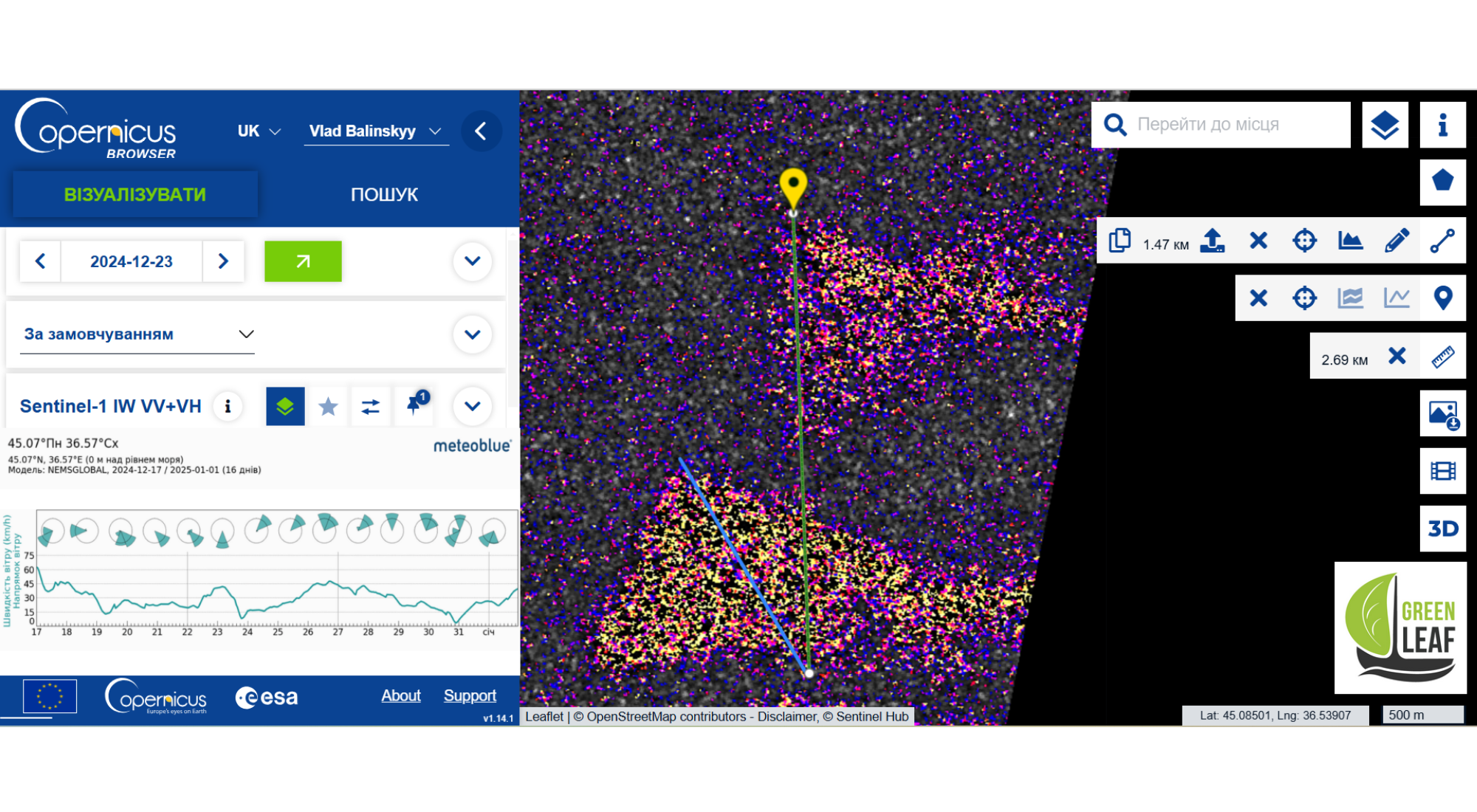
The next image is dated 23.12.2024, but a lot has changed
First of all, don’t be surprised: the area we are surveying is just at the edge of the satellite’s radar coverage, but we have more than enough information. You may be wondering, these white stars above and below are ships.
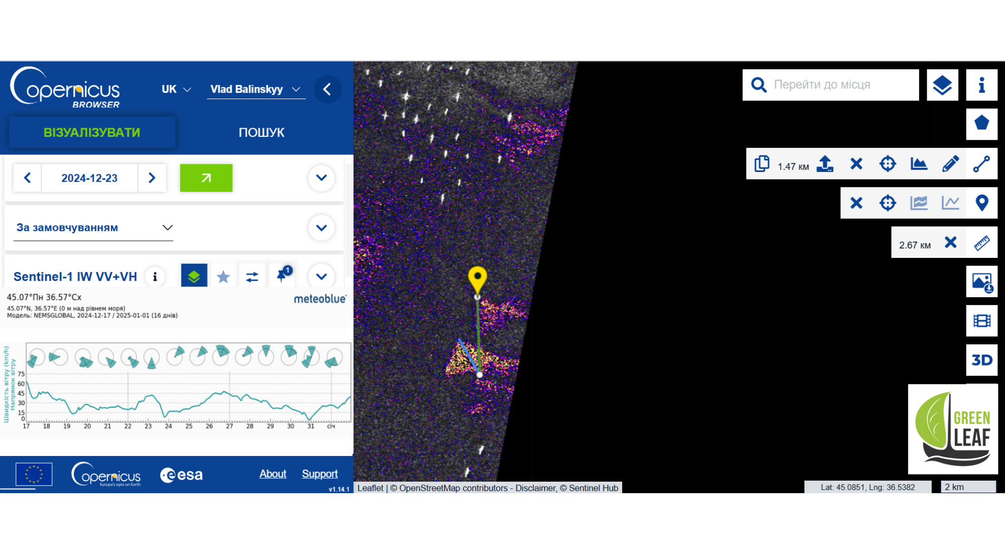
The blue segment, already shortened by 471 metres from Figure 9, has moved to this image 11, and what do we see here? The wind has changed several times, and because of this, the plumes have taken the form of a triangle, the catenaries of which correspond to the direction of the prevailing winds. We can see that 212-2 remains almost in the same place (now at the top of the obtuse corner of the plume).
But the mega-active fragment 212-1 managed to leave the characteristic shape of the plume in its old place and jumped 2.69 kilometres to the north. Please note that the direction of spread of fuel oil stains (plume) is 100 per cent dependent on the wind direction. The same applies to surface facilities. As for objects underwaterthe direction of their movement depends on the direction of the current, which, in turn, depends on many factors in the strait.
Leakage dynamics and fuel oil residues on the bottom
We would like to draw your attention to the fact that the initially “modest” part of 212-2 is already smoking, God forbid! Most likely, in the absence of sealing work, the tanks that survived the accident also began to lose fuel oil underwater through breather pipes and technological holes.
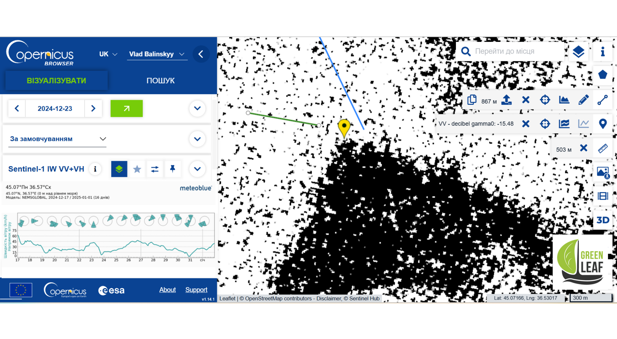
Also, a pale, characteristic plume at the site of the former position 212-1 may indicate a significant local accumulation spilled fuel oil on the bottom, which, when floating, forms a characteristic pattern on the surface.
That is, it is most likely that the free-moving part of 212-1 is flooding the bottom fuel oil as it moves, which is also confirmed by photograph 15 (below). You can see that plumes are coming not only from the points where the wreckage is located in the image, but also from the sharp apex of the triangle, where the 212-1 wreckage was located until 23.12.24.
Fuel oil leaking from all the wreckage
The next picture was taken just before the New Year on 31.12. Look at the killer beauty! For a more contrasty reflection and beautiful shots, I use the custom script “Oil Slicks and Red Tide Monitoring” from ľIZNEGAR Startup Co, thanks!
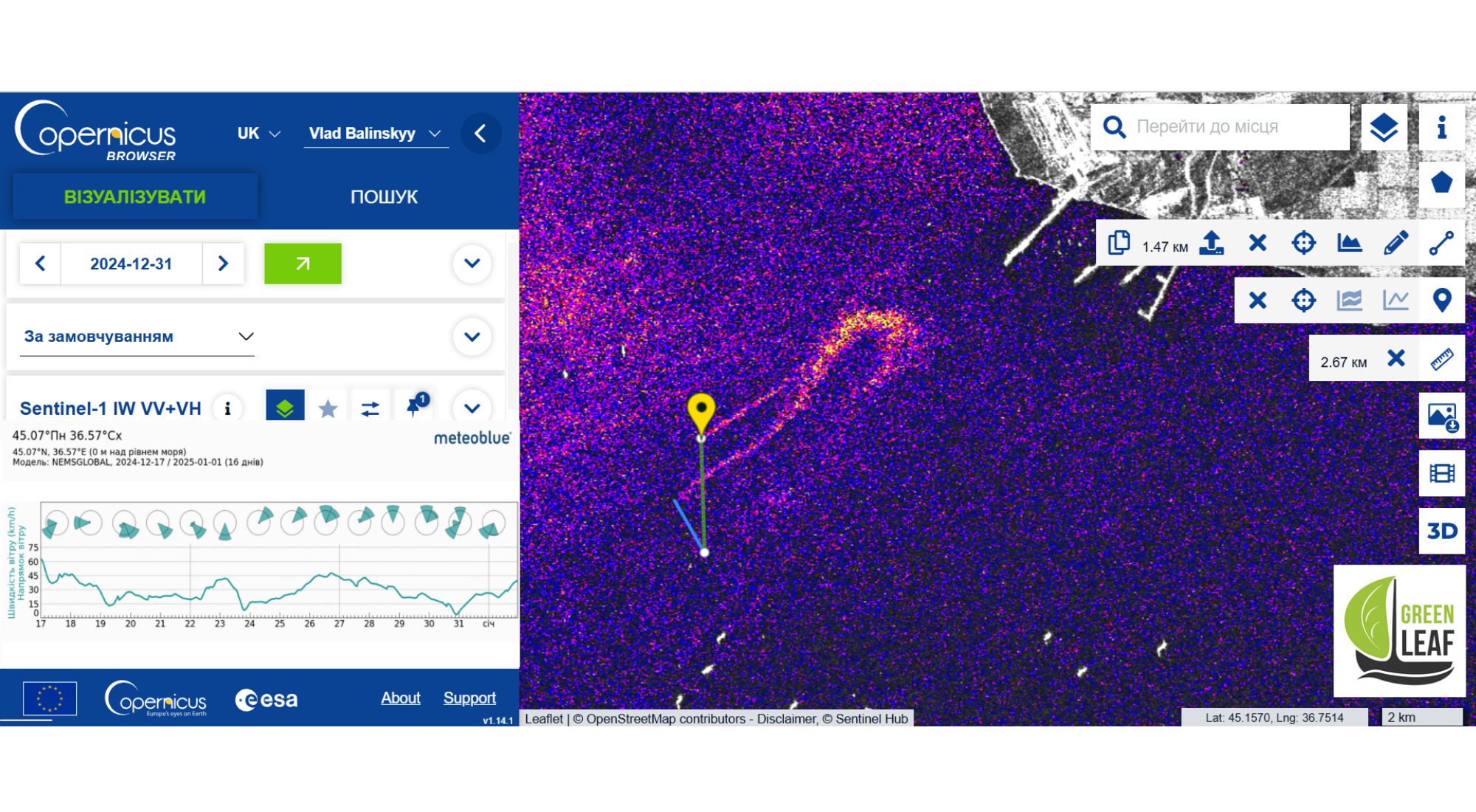
Part 212-2 continues to remain almost in its original position. Surprisingly, the 212-1 wreckage has also remained in place over these eight days, which may also be due to the topography of the bottom. Look at how beautifully these deadly fuel oil plumes are blending and bending in the picture. The coastal sea area is characterised by breezy changes in wind direction with the formation of similar vortex loops. Please note that 212-2 has also been slightly “blown away” during this time.
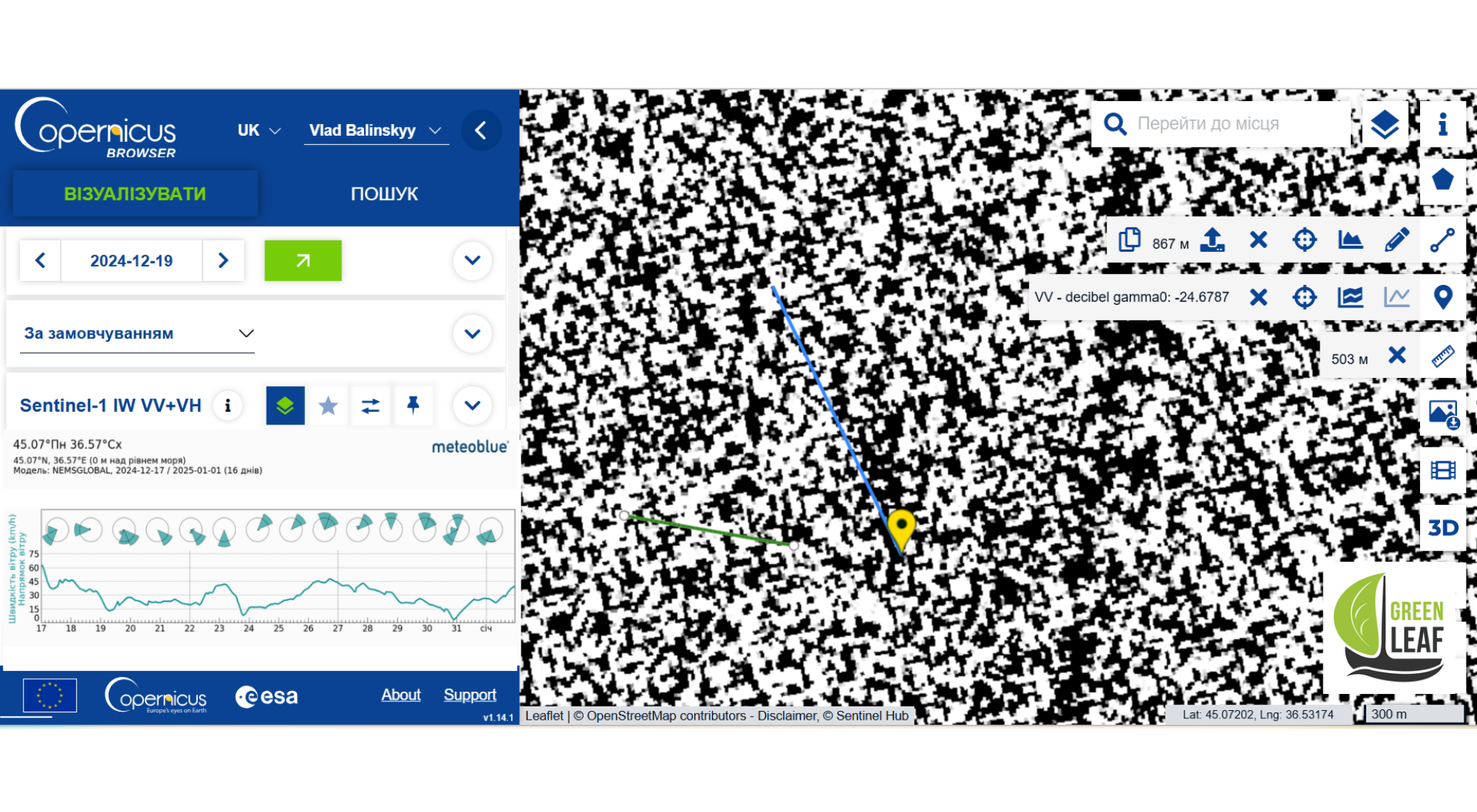
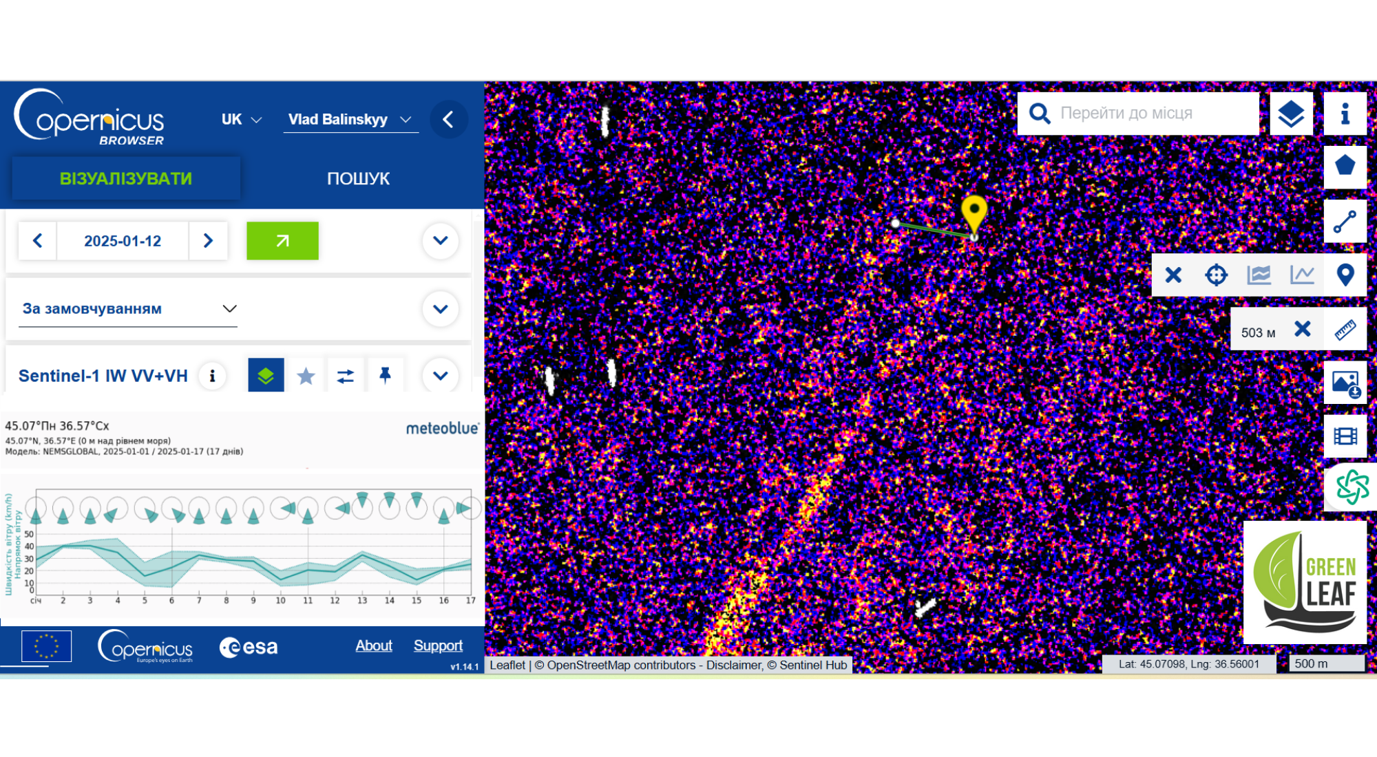
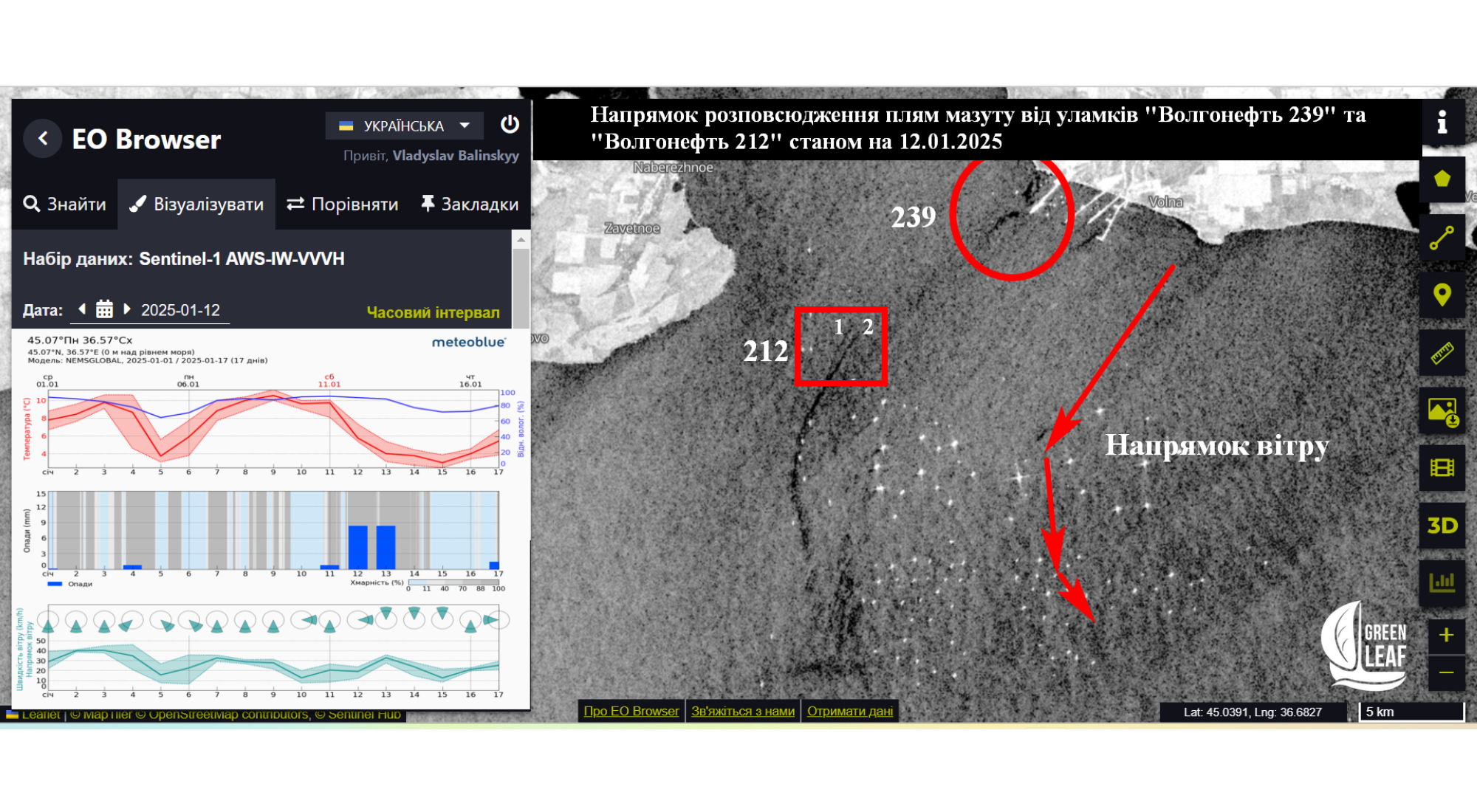
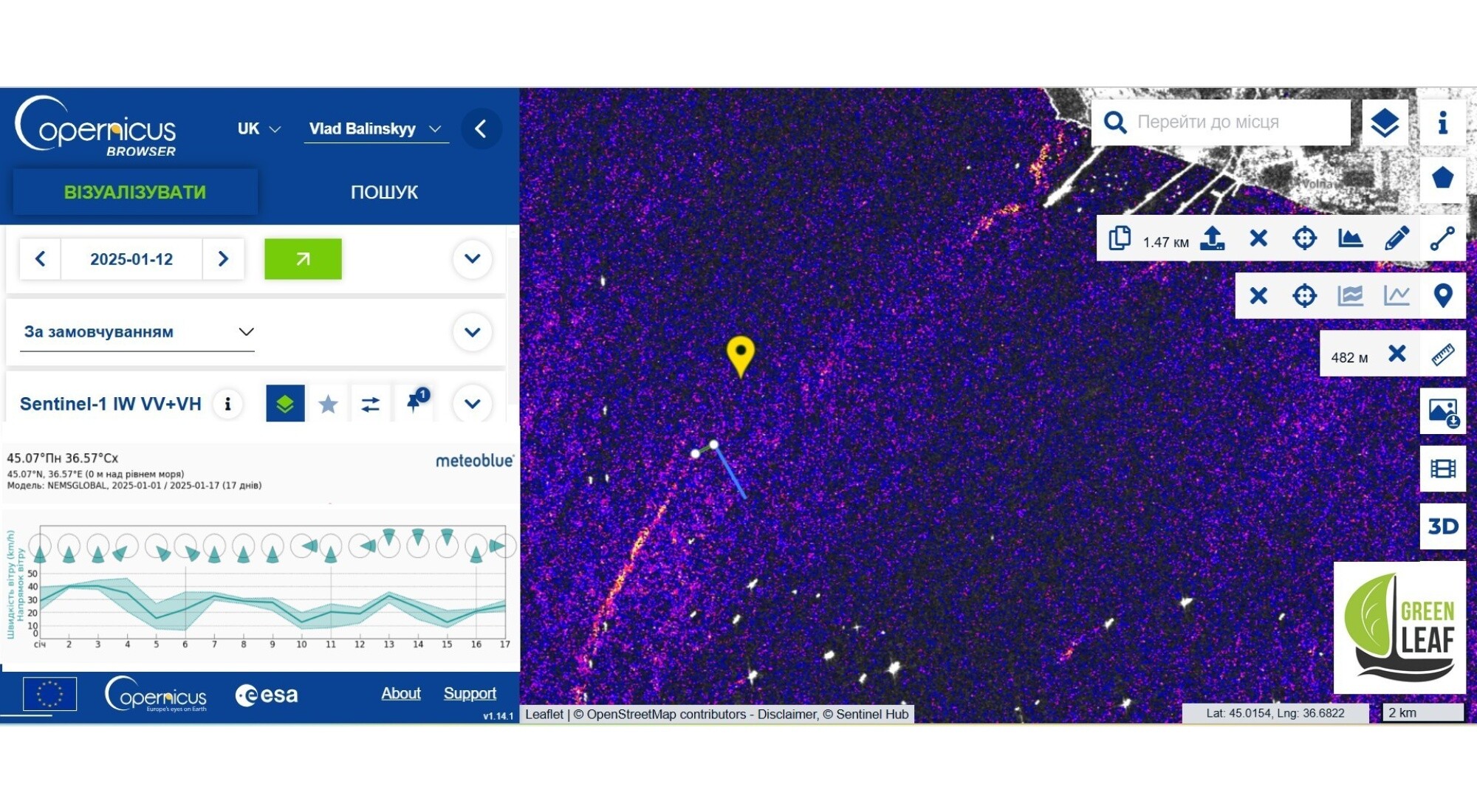
The next image from 11.01.2025 is not very good. Clouds are not an obstacle for the Sentinel-1 radar satellite when imaging objects such as ships. Unfortunately, subtle ripple patterns on the water surface are not always visible. And the last picture available today is a photo from 12.01.2025. It is a very revealing photo. Let’s study it.
I would like to draw your attention to the fact that from the beginning of 2025 until 11 January, southerly winds of relatively uniform intensity prevailed. At the same time, winds of a certain rhumb can cause quite strong currents at the exit from the Kerch Strait.
Debris drift map
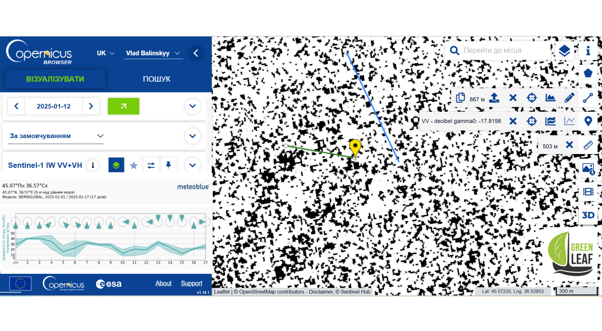
In this case, half of 212-1 moved to the south. The image from 12 January showed the two halves almost opposite each other at a distance of 503 metres. This is small compared to the total journey of the 212-1 wreckage of more than 6.85 kilometres in a dense shipping area. The total distance travelled by the two wrecks of the Volgoneft 212 between 15.12.2024 and 12.01.2025 was over 8.25 kilometres.
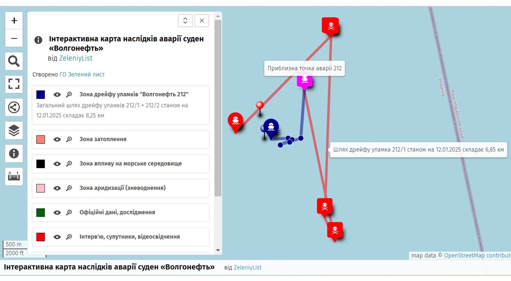
I say “more” because who knows what other loops these wreckage have cut before we saw them. I entered the coordinates of all the points into the Google Earth project, and then transferred them as a kml file to an interactive map created on the basis of OpenStreetMap. All the intermediate positions of both parts of the Volgoneft 212 vessel for the period 15.12.2024 – 12.01.2025 can be seen on the map by going to the of the active window.
“`html
View Fullscreen Copy Map Link Submit Data
“`I would like to warn you right away that this map is based on the ‘Interactive Map of the Consequences of the Kakhovka Tragedy’, which was presented by Green Leaf on 03.09.2024 and created with the support of Journalismfund Europe. The map still needs to be filled in with new objective data. Unfortunately, there is plenty of time for this – we will have to study the consequences of these two tragedies for the next decade.
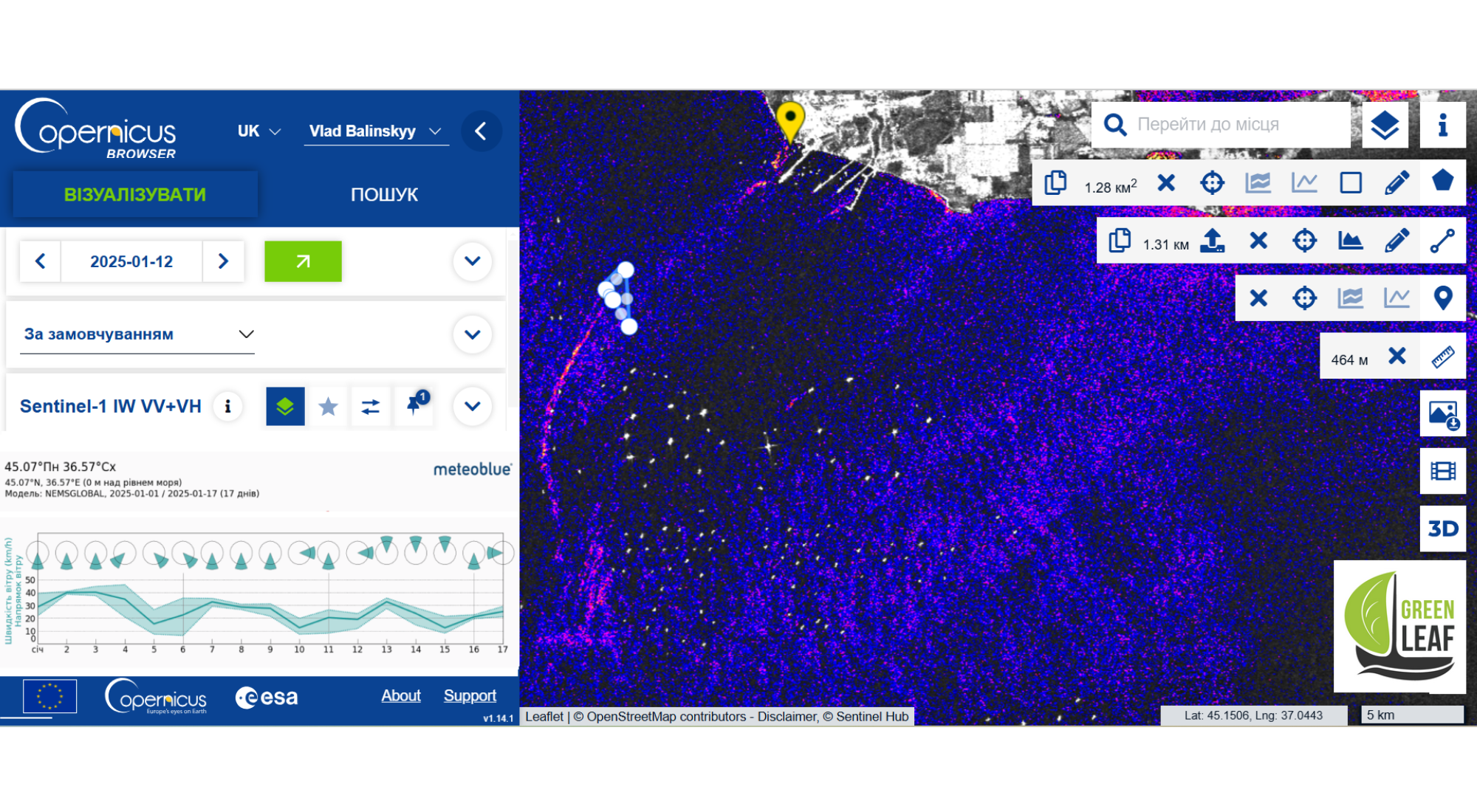
Spread of fuel oil stains
I would also like to use this image to show how fuel oil stains from the wreck of the Volgoneft 239 vessel on the shore and two wrecks of the Volgoneft 212 were carried into the sea on 12 January, continuing to cause irreparable damage to the entire closed ecosystem of the Azov-Black Sea basin!
Visual confirmation, buoys on the surface
The coordinates of all intermediate locations, of course, were recorded in the photographs and saved separately. Now, as for visual confirmation. As a self-control, leaving all the marks in the working field, I downloaded several successful Sentinel-2 images. Of course, it would not hurt to look at these coordinates from satellites with better resolution. It is quite difficult to see anything with a resolution of, at best, 10 metres per pixel.
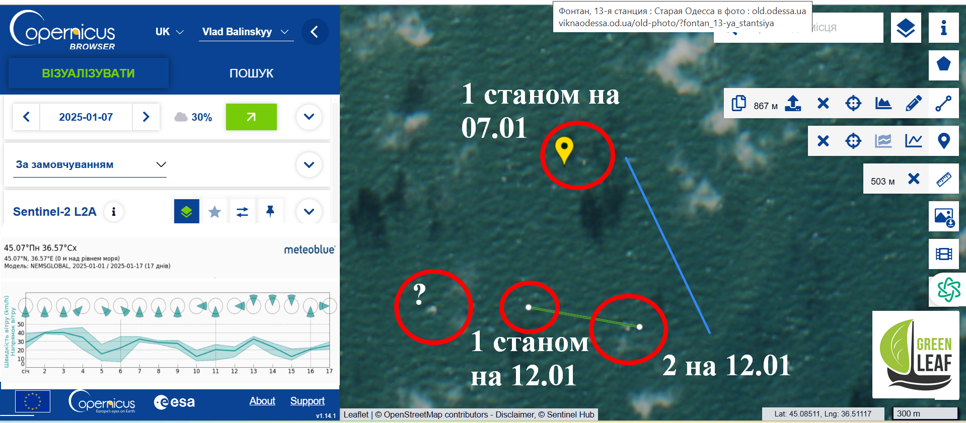
The wreckage is drifting in a busy shipping channel and should have at least been marked by buoys on the surface. Imagine the degree of irresponsibility when, instead of anchoring the wreckage, they simply tied signal buoys to it, with which it successfully drifted. Since the method I have proposed is approximate, for me, the presence of visible objects on the water surface (buoys?) actually right on my Sentinel-1 calculated marks is sufficient proof of its applicability.
Conclusions
1. The analysis of Sentinel-1 radar images made it possible to determine the coordinates of the wreckage of the Volgoneft 212 vessel underwater based on fuel oil stains. The two wrecks of the Volgoneft 212 vessel were not anchored after the 15 January 2025 wreckage and continued to drift, spreading tonnes of fuel oil along the way. The total drift distance by 12 January 2025 was at least 8.25 km.
2. Both wrecks of the Volgoneft 212 tanker are located in the territorial waters of Ukraine (closer to Crimea than to Taman). The tanker also broke up on our side.
3. No work has been done to seal the tanks. There is a clear dynamics of increasing emissions over time, for example, the initially cleaner wreckage of 212-2 and the stern of Volgoneft 239, which is on the shore. Most likely, this is due to fuel oil leakage from the technological holes and breather pipes of the tanks. The officially stated amount of 2,300 tonnes of Russian fuel oil emitted corresponds to the volume of four of the eight tanks on the Volgoneft 212 and is not true. The images clearly show fuel oil leaks from all three wrecks, meaning that fuel oil has been leaking for at least a month, including from the allegedly undamaged tanks.
Conclusions
4. The ship’s wreckage leaves fuel oil residues on the bottom during drifting, which subsequently forms a plume on the surface for some time and is perceived as a separate source of pollution when analysing satellite images.
The accident of the Volgoneft 212 and Volgoneft 239 tankers has become another challenge for Ukraine in a series of crimes committed by the Russian Federation against humanity and nature. Investigating the circumstances of this accident can provide answers to many questions. However, journalists of international media, concerned environmentalists and citizens are forced to draw reliable information from Russian official sources and from allegedly opposition telegram channels. Both are extremely unreliable in the context of the information war.
russian environmental opposition
Recalling the methods and budgets of the Russian Federation’s Goebbelsian-like propaganda, it is safe to say that every word is checked against the “party policy” (FSB) before publication. Thus, the first month after the accident, the Russian Federation spent not on technical, but exclusively on propaganda tasks to unite the “environmental opposition”, create the appearance of vigorous activity and divert attention from the problems of war, the shadow fleet and the falling economy.
We would like to thank Vitaliy Gulivets (National Ecological Centre of Ukraine) and Tetiana Gerasymova for their assistance in research and preparation of materials
Vladyslav Balinsky, head of the Green Leaf NGO, chemist, biologist