Category Archive War Chronicles

ByVladislav Balinsky

From the Kerch Strait to the Gulf of Finland: The Simulation of a Sea “Cleanup”, russia’s Diesel Deal and the Threat to the Baltic

Vladyslav Balinskyy · biologist, head of the Green Leaf NGO

On 21 August 2026, Moscow announced that it had pumped heavy fuel oil out of three sunken sections of the tankers Volgoneft-212 and Volgoneft-239. The announcement was repeated on 25 September, this time with a claim that the affected waters had been cleaned up. Then, on 9 October, donald trump announced an agreement on supplies of russian diesel fuel and a temporary easing of the relevant sanctions restrictions. These events are connected by more than their proximity on the calendar. What we are seeing is an attempt to turn an environmental disaster, whose effects remain visible from space, into a story of a “problem successfully resolved”.

I have been investigating this accident since December 2024. On satellite images acquired even after the announcements in August and September, I can still see extensive surface plumes originating near the same submerged objects. The time series available to me shows no clear break in the pattern, either during the purported final stage of the operation or afterwards. That is why I regard the campaign of announcements about a “complete cleanup” as an informational simulation of an environmental result. And the strongest argument here comes from the russian authorities’ own experience: when they genuinely pumped out fuel oil in 2025, they themselves showed exactly how it was done.

1. Two “pumping operations” — and two entirely different ways of reporting them

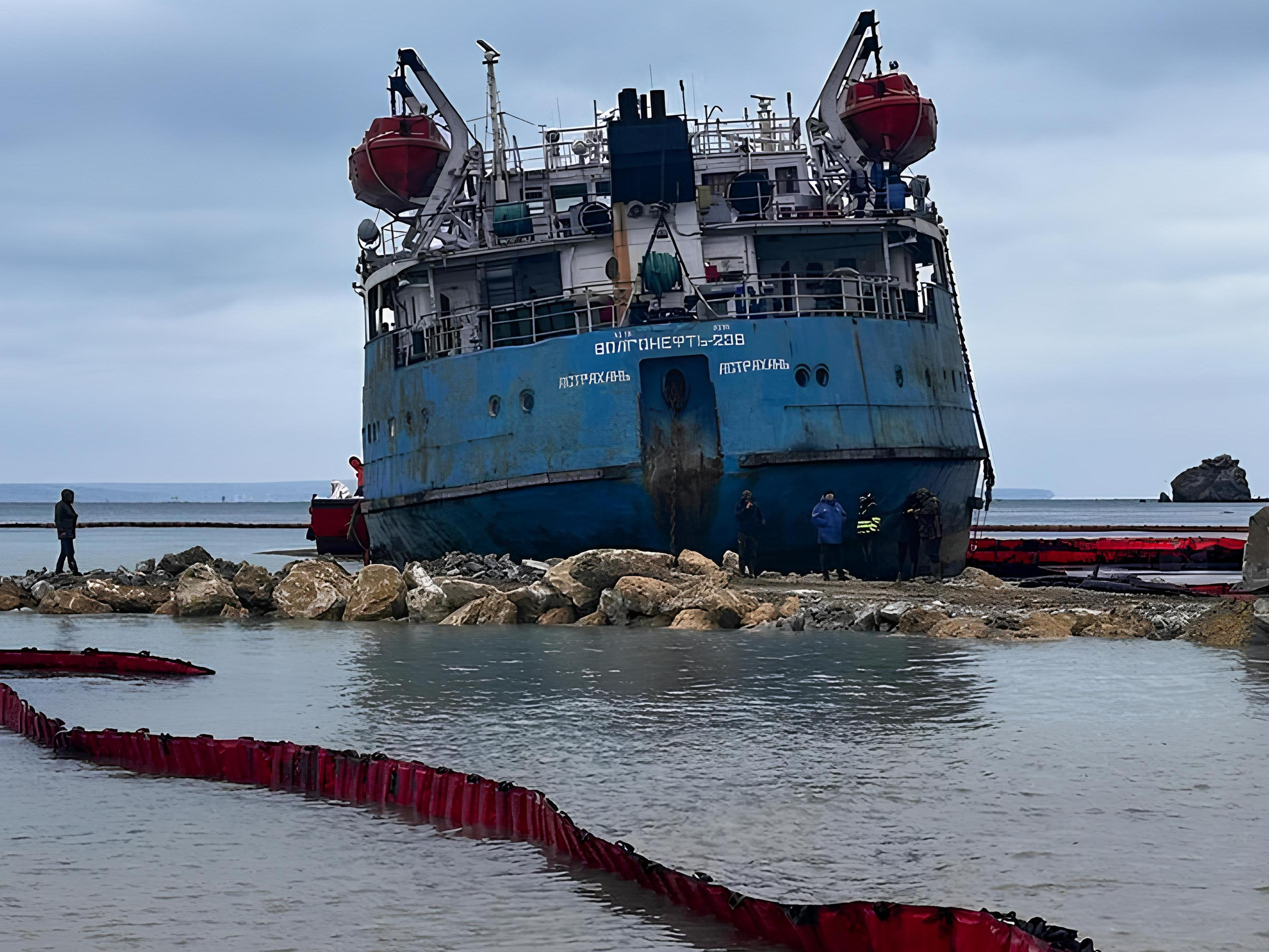
In January 2025, the stern section of Volgoneft-239 lay grounded in shallow water near Cape Panagia. It was an enormous wreck, visible from shore, with fuel oil in four tanks. A protective embankment and access road were built around the hull. The vessel’s equipment was restored. To make the viscous fuel oil pumpable, it was heated to approximately +45°C using the ship’s systems and steam supply. The fuel was then transported away in heated, sealed bitumen tankers. Photographs, videos, technical details of the operation and daily interim figures were made public.

On 20 January, the first 70 m³ were reported; on 22 January, 727 tonnes; on 23 January, more than 1,100 tonnes; and on 24 January, approximately 1,300 tonnes. According to the final report on dismantling the wreck, more than 1,400 tonnes of fuel oil and other fuel had been pumped out before the hull was cut up, its compartments had been cleaned, and dismantling was completed in March 2025. All this can be checked against the sequence of public reports and photographs. This was not an abstract statement that “a special commission confirmed it”: the technology, the object, the quantity and the outcome were materially documented.
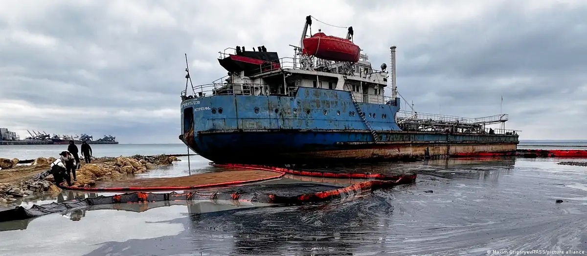
Grounded stern section of Volgoneft-239 near Cape Panagia during the January 2025 response operation
Photo 1. The stern section of the tanker Volgoneft-239 grounded near Cape Panagia during the response operation, January 2025. Photo: Maxim Grigoryev / TASS / picture alliance.

Now compare that with the three sections lying on the seabed at a depth of about 20 metres. In March 2025, russia’s Ministry of Transport published a plan involving three heavy protective cofferdams, sealing the wrecks, pumping out fuel oil beneath the enclosures and subsequently raising the sections. Preparatory work and removal of superstructures were reported later as well. As recently as March 2026, according to RBC, the russian government still estimated that roughly 2,000 tonnes remained in the bow section of Volgoneft-212 alone. The scale of the operation was therefore well understood, and the engineering challenge was far more complex than at Cape Panagia.

So what was reported on 21 August and 25 September 2026? “Pumping completed”; “commission confirmed”. But where is the video of the actual underwater operation? Where are the figures for the fuel oil truly recovered, its transport and its ultimate disposal or use? Photographs of preparations for installing cofferdams do not prove that pumping was completed. Why did authorities who readily reported virtually every bitumen tanker in 2025 now confine themselves to a declaration?

There is also a financial dimension. The stern section could be enclosed by an embankment, heated using its own systems, and its product pumped into land transport and sold. An underwater operation requires heavy isolation structures, diving and offshore work, different engineering and different budgets. Who commissioned and financed it? Where are the acceptance certificates, actual quantities of recovered fuel oil and documents tracing what happened to it? These are elementary questions that an operation of this scale ought to answer.

2. Where did thousands of tonnes go — and why have the plumes not disappeared?

Together, the two tankers were carrying about 8,450 tonnes of heavy fuel oil. According to estimates by the International Oil Pollution Compensation Funds (IOPC Funds), as much as 5,000 tonnes entered the sea during the accident. More than 1,400 tonnes were subsequently pumped out of the stern section of Volgoneft-239, which had grounded in the shallows near Cape Panagia. Yet a full accounting of the fuel oil remaining in the sunken sections and already released into the marine environment has still not been made public.

The consequences of the disaster did not end with the initial spill. A substantial amount of heavy fuel oil settled on the seabed and accumulated in coastal sediments, forming reservoirs of secondary contamination. Under the influence of storms and currents, these deposits can once again release fuel oil into the water and transport it onto the shore. Repeated strandings were observed around Anapa, Vityazevo and the Bugaz Spit. Lumps of fuel oil were found even along the coast of Tuzly Lagoons National Nature Park, more than 600 km from the accident site. Field surveys in 2026 found both fresh fragments and older residues beneath a layer of sand. Thus, contamination continues to manifest itself far beyond the disaster area, despite official claims that the problem has been “eliminated”.

From December 2024 to 21 October 2026, we accumulated hundreds of archived satellite scenes. Throughout this period, extensive plumes have repeatedly appeared, with their initial sections located near the same sunken tanker fragments. This continuous series of observations makes it possible to compare conditions in the area before and after the purported “pumping operation”.

For comparison, let us look at three representative images from 2025, before completion of the underwater pumping was announced.
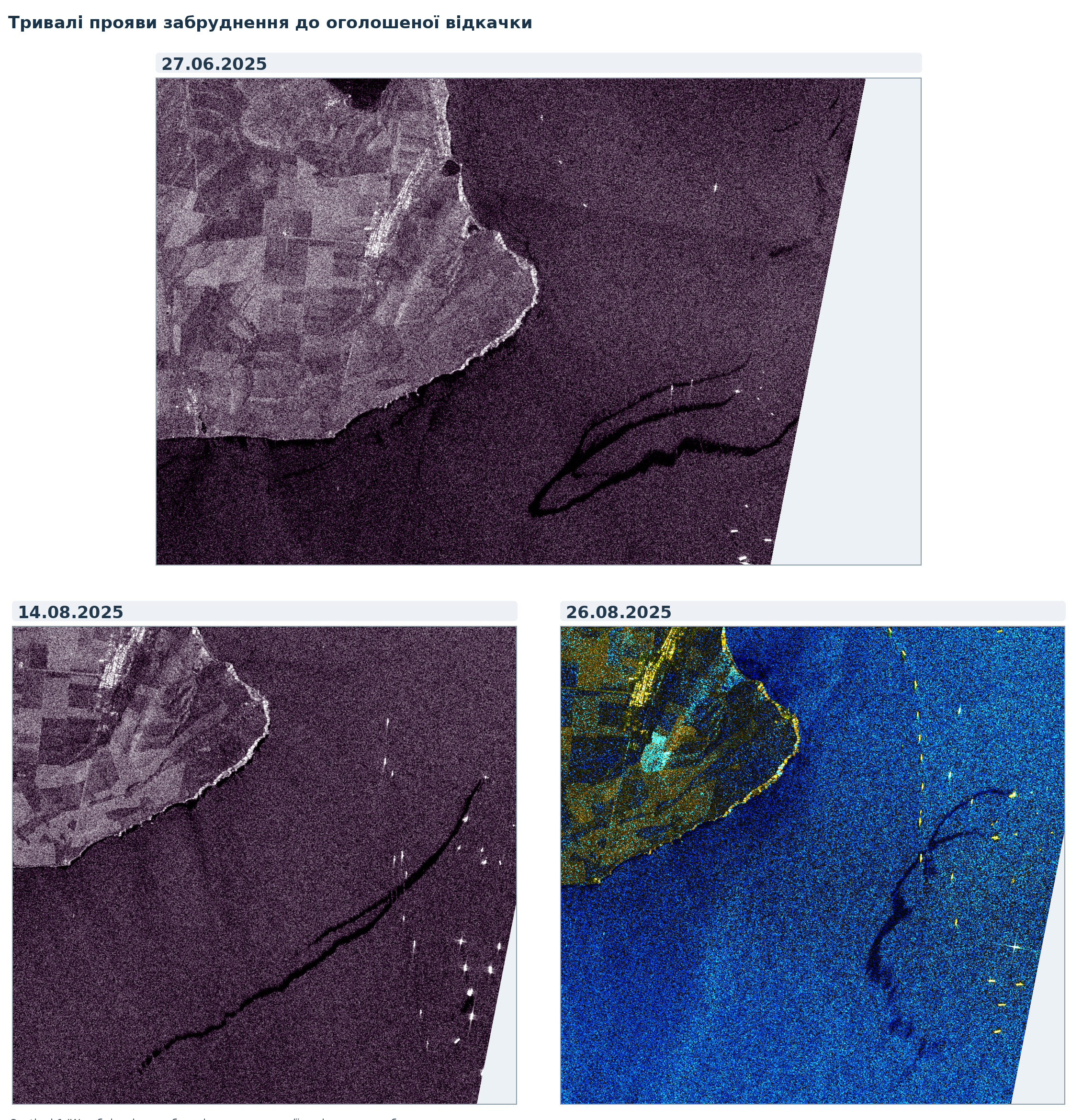
Three Sentinel-1 radar scenes dated 27 June, 14 August and 26 August 2025 with dark plume-like signatures
Figure 1. Sentinel-1 radar scenes dated 27 June, 14 August and 26 August 2025. Extensive plume-like signatures before the announced pumping operation. Source: Copernicus Sentinel-1; selection and analysis by V. Balinskyi.

Sentinel-1 radar images dated 5, 9 and 21 October 2026 — all after the official announcements that pumping had been completed — again show extensive dark, plume-like structures near the locations of the sunken wreck sections. Compared with previous months, I see no appreciable reduction in the intensity of these signatures or shift in the places where they form. To me, this is evidence that the public messaging about “cleaned-up waters” does not match the observed picture of persistent contamination.
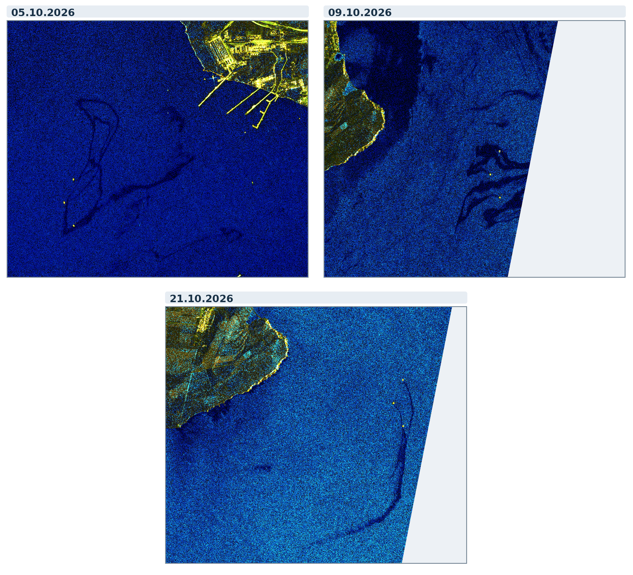
Three Sentinel-1 radar scenes dated 5, 9 and 21 October 2026 with dark plume-like structures
Figure 2. Sentinel-1 radar images dated 5, 9 and 21 October 2026. Source: Copernicus Sentinel-1; selection and analysis by V. Balinskyi.

For me, this is the central contradiction. If the submerged tanks really were completely emptied, why do plumes keep appearing near the same objects? If some of the signatures result from the secondary release of fuel oil that previously settled on the seabed, on what grounds were the waters declared “cleaned up”? In either case, a press release cannot substitute for actual results from marine monitoring.

3. Why announce victory now? August, September, October

More than twenty months passed between the accident on 15 December 2024 and the first announcement that underwater pumping had been completed. On 21 August 2026, completion of the work was announced; on 25 September, the outcome was repeated and the affected waters were declared clean. On 9 October, the US president announced an agreement on russian diesel supplies and temporary sanctions relief. On 15 October, Reuters reported that exports had resumed and that a tanker carrying 40,000 tonnes of diesel, loaded at the Baltic port of Primorsk, was heading to Morocco.

This sequence warrants political scrutiny. russian petroleum products are returning to international markets, the russian authorities are demonstrating an ability to supply them, and it is precisely at this time that one of the most serious heavy-fuel-oil disasters in recent years is declared resolved. We do not have a direct document proving that the dates of specific press releases were coordinated with the diesel negotiations. But the coincidence of an environmental “success” with the restart of fuel trade is sufficiently advantageous to the Kremlin to raise the question of a deliberately planned information campaign.

This is where my main argument emerges: the unproven cleanup of the sea has become a convenient element in the image of “normal”, managed russian fuel trade. I see no meaningful environmental improvement in my satellite time series, and the final press releases contain no transparent technical account comparable to the operation at Cape Panagia. Therefore, until actual recovered volumes, an engineering report and independent monitoring results are made public, I regard the official “environmental victory” as an imitation rather than an established fact of cleanup.

4. The problem goes beyond Kerch — and did not begin with the war

The Volgoneft accident was not the result of Ukrainian strikes. Similarly, on 11 November 2007, Volgoneft-139 broke apart in a storm in the Kerch Strait: around 1,300 tonnes of heavy fuel oil entered the sea, and tens of thousands of birds were affected. These accidents are associated with the hazardous use of river–sea-class vessels, their technical condition and risky operating practices. We have examined the warnings issued by naval architect Gennady Yegorov and the accident record of Volgoneft-class tankers in detail in Green Leaf.

Moreover, the Kerch–Taman hub is only the central link in a wider network. Novorossiysk, Tuapse, Taman, Port Kavkaz and the transport routes serving them form a major Black Sea fuel-logistics system; Rostov, Azov, Taganrog and the occupied ports of the Sea of Azov are connected to the wider system of maritime and river transport. They serve different functions and not all are oil-loading ports. Nevertheless, accidents, transshipments and weak oversight spread risks far beyond their immediate locations. A particular hazard is the bidirectional, shifting exchange of water through the Kerch Strait and the subsequent transport of contamination by currents in the Azov and Black seas.

Map 1. Interactive map of environmental evidence from the Black Sea. Locations of documented cases of marine pollution. Map data are regularly updated.

Open the interactive map full screen ↗

Military strikes may add acute accident risks, but they did not create the underlying problem of an unsafe tanker fleet.

Shadow shipping arrangements, complex ownership chains, inadequate insurance, ship-to-ship transfers and technically deteriorated hulls are dangerous even in the absence of strikes. It is this systemic risk, which has already materialised repeatedly in the Azov–Black Sea basin, that russian fuel trade is now carrying into the Baltic Sea.
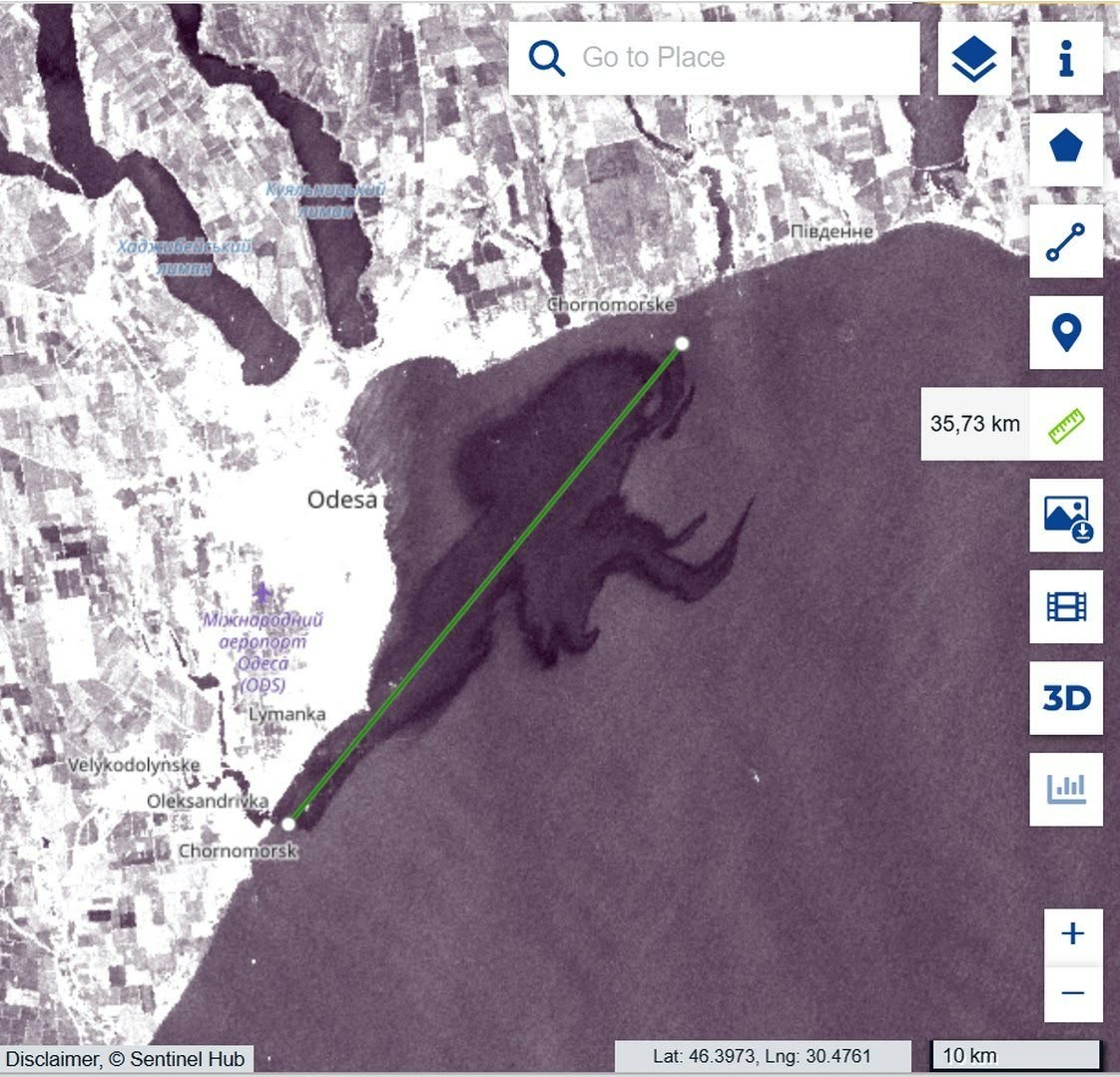
Copernicus Browser image near Chornomorsk with a green measurement line indicating 35.73 km
Figure 3. Satellite image of the waters near Chornomorsk following a vegetable-oil spill caused by a strike on port infrastructure. The green line marks a measured distance of 35.73 km. Source: Copernicus Browser.

5. The Baltic Sea: risks that cross borders

Primorsk, Ust-Luga and other Baltic-facing ports operate on the shores of a semi-enclosed sea characterised by restricted water exchange, seasonal ice, intensive shipping and particularly sensitive coastal and benthic habitats. According to Reuters, shipments of petroleum products from russian Baltic ports increased by 32.7% in August 2026 compared with July, while shipments via Black Sea and Sea of Azov ports fell by 25.3%. This indicates a shift in the structure of trade flows, although it does not mean that each cargo was literally transferred from south to north.

Here lies the second important strand of this story. In the Azov–Black Sea basin, we can already see the consequences of a hazardous transport system: ageing and technically problematic vessels, opaque operators, transshipments, prolonged spills and reservoirs of recurring contamination. Our satellite monitoring cannot capture every incident across such an immense area, but even the documented signatures demonstrate that these are not merely hypothetical risks. What is being transferred to the Baltic is not any one accident, nor necessarily the same vessels, but the fuel-logistics model itself — and with it, a threat to the entire region.

Researchers have already assessed the scale of that threat. According to a study by Sabine Knapp and colleagues published in Marine Pollution Bulletin, modelled oil-pollution risk exposure from oil tankers in the Gulf of Finland increased by approximately 133% between 2023 and 2024 alone. Vessels on the shadow-fleet watchlist account for 54% of estimated risk in the Gulf, compared with a global average of 16.4%. Assuming the underlying conditions remain unchanged, the researchers project further growth in that risk of approximately 2.7% per month. These are estimates of potential accident consequences, not quantities of oil already spilled. Nevertheless, the scale of the increase shows the price that this trade could exact on the Baltic Sea.
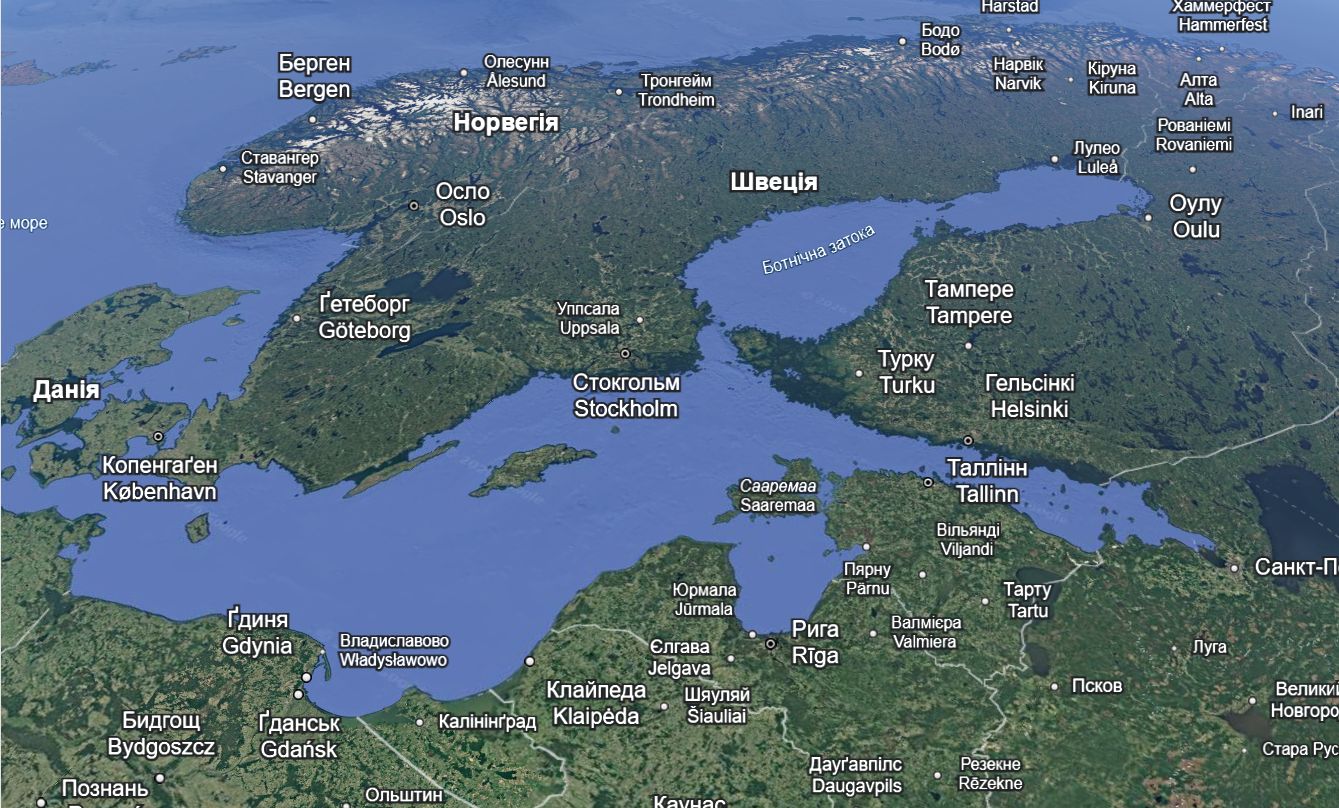
Map showing the Baltic Sea, Gulf of Finland and surrounding countries
Figure 4. The Baltic Sea and Gulf of Finland — geographic context of maritime transport risks.

In the Gulf of Finland, a major spill means far more than a slick temporarily visible on the sea surface. Relevant processes include dispersion, sorption onto suspended particles, accumulation of petroleum products in bottom sediments, secondary remobilisation and long-term effects on benthic communities and trophic networks. If the shipowner, operator, insurer and ultimate beneficial owner are opaque, the question of who will pay for cleanup, ecosystem restoration and long-term monitoring becomes no less important than the accident risk itself.

Natural conditions only compound the danger. The Baltic Sea is shallow and almost enclosed; according to HELCOM, complete water exchange with the North Sea takes approximately 30 years. A major accident here would therefore threaten not only the waters of a port but also the coastlines and marine ecosystems of numerous countries — Finland, Estonia, Latvia, Lithuania, Poland, Sweden, Germany and Denmark. Petroleum products transported by currents may accumulate in bottom sediments and coastal habitats, only to be released into the water again later. Restoring such ecosystems is vastly more difficult than removing a visible slick from the surface.

Conclusion: Fuel deals without environmental accountability

The story of the announced fuel-oil “pumping operation” in the Kerch Strait matters not only as an example of information manipulation. It shows how an unresolved environmental problem can be pushed off the political agenda by declaring it “eliminated” at the very moment international trade in russian fuel is resuming. Neither the recurring plumes in the Black Sea nor the systemic risks of tanker operations disappear as a result.

The Kremlin’s repeated references to the so-called “spirit of Anchorage” signalled a desire for broader political agreements with the United States, while the October diesel agreement demonstrated a very concrete economic interest. Yet public presentations of these arrangements leave out environmental consequences, the technical condition of vessels and the safety of European coastal states. Where verification and accountability are needed, the russian side offers announcements of “environmental victories”. Some reap the benefits of trade, while others — above all the countries of the Baltic region — may bear the risk of pollution lasting for years. We will continue to monitor the consequences in the Black Sea and show why a repetition of this scenario in the Baltic would be dangerous. Europe needs to assess the environmental cost of fuel agreements before the next disaster, not after it.

Materials and sources

Field observations of heavy fuel oil in Odesa region:

Public documentation of the stern section of Volgoneft-239, January–March 2025:

Sunken sections, 2025–2026:

Quantities and international assessment:

Diesel agreement and shipping:

Scientific and hydrological assessments:

Map of environmental consequences:

Political context:
ByVladislav Balinsky

TuzlyResilience Project Launched: Communities and Environmentalists Unite to Strengthen the Resilience of the Tuzly Lagoons Coast

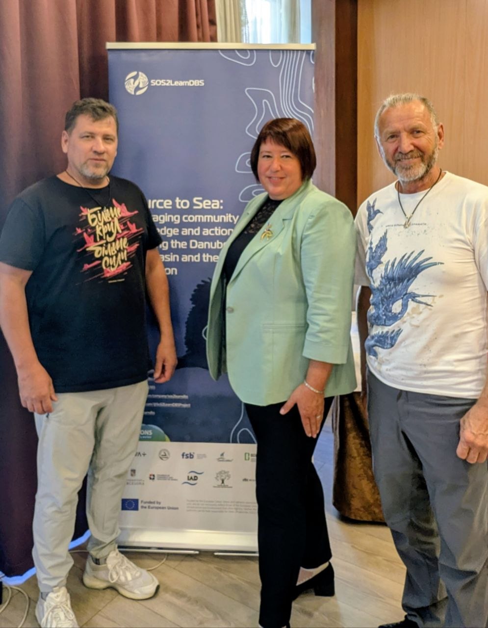
On 1 October 2026, the first meeting of participants in projects funded under the European SoS2LearnDBS initiative took place in Budapest. The new Ukrainian project TuzlyResilience was presented at the meeting. Over 30 months, it will work to strengthen the resilience of the coastline of Tuzly Lagoons National Nature Park and neighbouring communities.

The SoS2LearnDBS project is funded by the European Union.

What Does TuzlyResilience Involve?

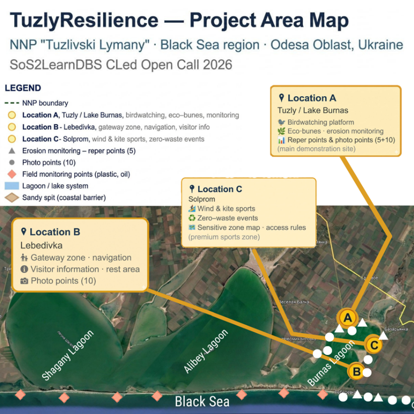
The project combines monitoring of coastal processes, nature-based protection against erosion, pollution prevention, managed recreation and active participation of local communities in decision-making. Specifically, a monitoring system comprising five reference points and ten photographic monitoring points will be established; eco-groynes will be tested at priority erosion sites; and a ‘Clean Season’ system and an oil pollution response protocol will be introduced. At three pilot locations — in the Tuzly/Lake Burnas, Lebedivka and Solprom areas — approaches to recreation compatible with nature conservation will be demonstrated.

Map showing the TuzlyResilience project area
Map of the TuzlyResilience project area. Presentation slide.

A distinctive feature of TuzlyResilience is that the community becomes not merely a participant, but a co-creator of solutions. Local residents will take part in monitoring the condition of the coast, nature conservation measures and defining the rules for using the pilot recreational sites.

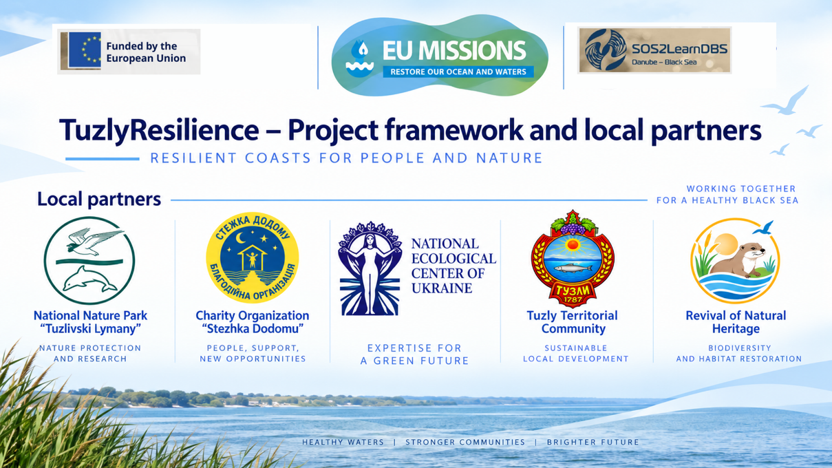
The project is implemented by a consortium of five Ukrainian organisations led by the National Ecological Centre of Ukraine (NECU): Tuzly Lagoons National Nature Park, the NGO Revival of Natural Heritage, the Stezhka Dodomu Charitable Foundation and the Finance Department of Tuzly Village Council.

Presentation slide showing the TuzlyResilience consortium partners
TuzlyResilience project partners. Presentation slide.

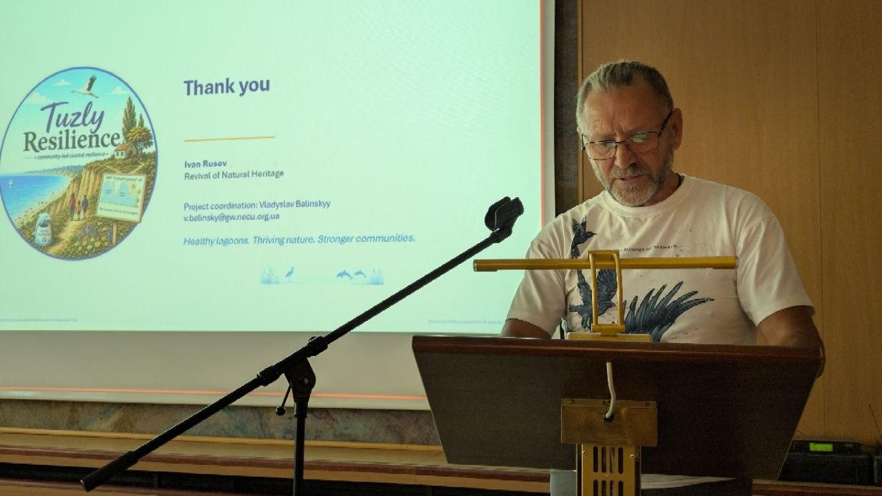
The project was presented by Ivan Rusev, head of the NGO Revival of Natural Heritage. He emphasised that the Tuzly Lagoons are a unique lagoon ecosystem with high biodiversity, important for birds, including pelicans and greater flamingos. At the same time, the area faces coastal erosion, marine litter and a need for safer, more responsible recreational use of the natural environment.

Ivan Rusev presenting TuzlyResilience in Budapest
Ivan Rusev presents the TuzlyResilience project in Budapest. Photo: Vladyslav Balinskyi.

The TuzlyResilience approach follows a sequence: baseline data → joint decision → pilot action → reassessment → replication. Thus, the project is intended not only to implement individual nature conservation measures, but also to develop a replicable model of coastal management that can be applied in other areas.

During the first six months, the plan includes launching the project and implementing safety measures, organising access to the area, establishing baseline monitoring points, jointly designing eco-groynes, holding the ‘Clean Season’ initiative and carrying out the first analysis of the results.

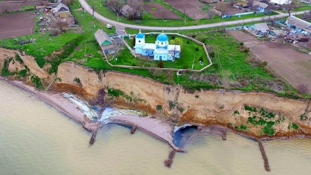
Nature-based coastal groynes in the village of Tuzly
A reference example of long-term nature-based coastal protection in the village of Tuzly: eco-friendly groynes built from locally available biomaterials near a nineteenth-century church. The structure has been functioning for almost a decade, promoting sediment accumulation and the natural formation of a beach. It provides local practical evidence supporting the suitability of an approach using eco-groynes developed specifically for this site. As part of TuzlyResilience, this approach will be designed, monitored and replicated at other sites. Photo: Ivan Rusev, Facebook.

SoS2LearnDBS: How Danube and Black Sea Communities Are Becoming Participants in the Restoration of Aquatic Ecosystems

TuzlyResilience is implemented within the SoS2LearnDBS project (Source to Sea: Leveraging Community Knowledge and Action for Restoring the Danube River Basin and the Black Sea Region), which aims to restore aquatic ecosystems in the Danube River Basin and Black Sea Region with the involvement of local communities. The project’s total budget is €12.5 million. SoS2LearnDBS is funded by the European Union under Horizon Europe and is linked to the EU Mission ‘Restore Our Ocean and Waters’.

The Danube is one of Europe’s major river systems and affects the condition of the Black Sea. Along with water from its basin, pollutants from agriculture, cities and industry reach the sea. This creates transboundary environmental problems and affects aquatic ecosystems and biodiversity.

For this reason, SoS2LearnDBS regards the Danube Basin and the Black Sea as an interconnected system — from the river’s headwaters to the seacoast.

The central idea of SoS2LearnDBS is that restoring aquatic ecosystems requires more than scientific research and technical solutions. People and organisations who live and work in these areas every day also play an important role.

The project therefore helps communities acquire knowledge and skills for working with aquatic ecosystems; participate in identifying environmental problems and priorities; jointly develop and implement practical solutions; obtain financial and technical support; assess the results of their actions; and share successful solutions with other areas.

In this way, the community is regarded not only as a recipient of information or a participant in consultations, but as one of the agents of restoration.

This is particularly important for the Black Sea Region, because environmental problems do not stop at administrative boundaries. The condition of river basins, deltas, lagoons and coastal areas is interconnected, while the effectiveness of many conservation measures depends on the involvement of local communities and authorities.

That is why SoS2LearnDBS aims to create not isolated, disconnected pilot projects, but a network of local actions that can be tested, improved, shared and integrated into long-term strategies for restoring aquatic ecosystems.

One of the key instruments of SoS2LearnDBS is cascade funding (Financial Support to Third Parties, FSTP). Open calls provide financial and technical support to local initiatives in which communities and organisations themselves participate in identifying environmental problems and in developing and implementing solutions. This system supports Community-Led Actions (CLed) — practical projects led by local participants — as well as Transition Agendas (TAg), roadmaps for long-term changes in aquatic ecosystem management.

SoS2LearnDBS began in September 2025. Its first phase focused on launching the project and preparing and holding calls for local initiatives. In 2026, following selection and the signing of agreements, implementation of Community-Led Actions — practical projects including Ukraine’s TuzlyResilience — began.

Funding acknowledgement banner with SoS2LearnDBS and EU logos
ByVladislav Balinsky

Grain, Oil or Fuel: What Was Really Burning at the Port of Taman

Environmental Monitoring · Satellite Analysis

Grain, oil or petroleum: what actually burned at the port of Taman. A spatial-dynamic analysis of the strike on the transport-and-fuel node of the Kerch Strait.

Vladyslav Balinskyi, editor-in-chief, «Zeleniy Lyst» · 8 August 2026

On 30 July 2026 Ukraine’s Defence Forces struck a transport-and-fuel node near the port of Taman that supplies fuel to the Russian grouping in the south. Despite the official Russian account of a “grain terminal” and the civilian label on the map, the satellite evidence points to burning petroleum products.

On the face of it the episode is clear: an enemy supply base destroyed. But once the parties’ statements are set against what the satellites actually show, the picture splits into three competing accounts of three different substances, and that discrepancy is where the real question lies. What burned on the shore of the Kerch Strait, and what the current is now carrying along the coast, we established not from statements but from instruments: backward drift modelling on Sentinel-1 and Sentinel-2 data, the thermal record from NASA FIRMS, and the actual wind regime from the strait’s weather stations.

Grain, oil or petroleum: concealing a military target

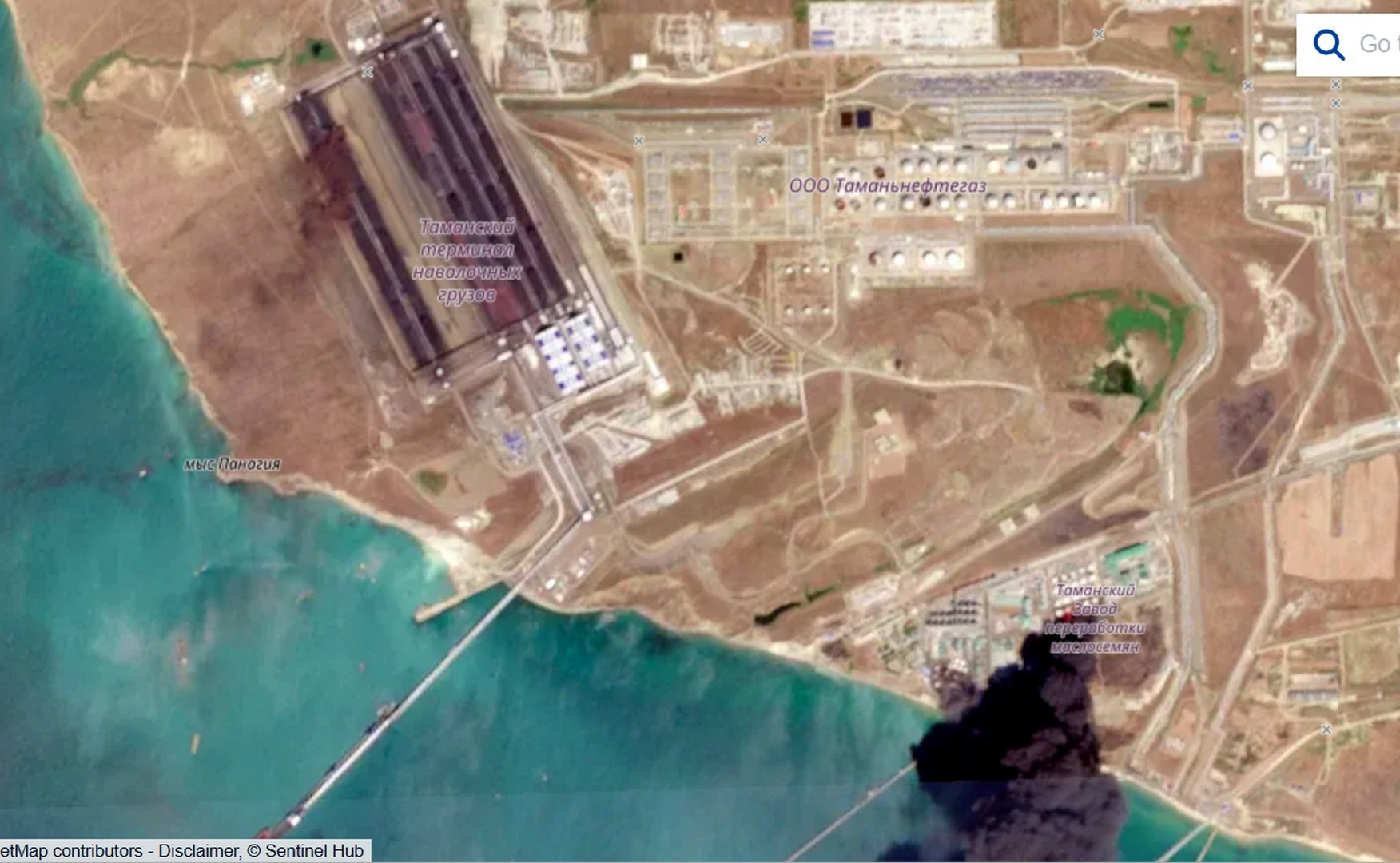
Once the scale of losses at the logistics hub became clear, the Russian side began contradicting itself. The transport prosecutor’s office reported damage to the port; an industry outlet insisted the affected facilities were “unrelated to petroleum transhipment”; and claims soon surfaced of a strike on a major grain terminal. Yet directly above the fire’s epicentre the satellite map carries an entirely civilian label: “oilseed processing plant.” Three accounts, three substances, and at least one of them is untrue.

Sentinel-2: intact Tamanneftegaz tank farm and black smoke above the facility labelled as an oilseed processing plant
Photo 4. Sentinel-2, 31 July 2026. The Tamanneftegaz tank farm is intact, while a black smoke column rises over the facility labelled as an oilseed processing plant. Source: Sentinel Hub / OpenStreetMap.

The grain framing is not accidental: it lets Russia invoke global food security and court international outrage. In this case, however, the substance is fuel, and that can be shown step by step.

Smoke does not lie: fuel that burned without pause

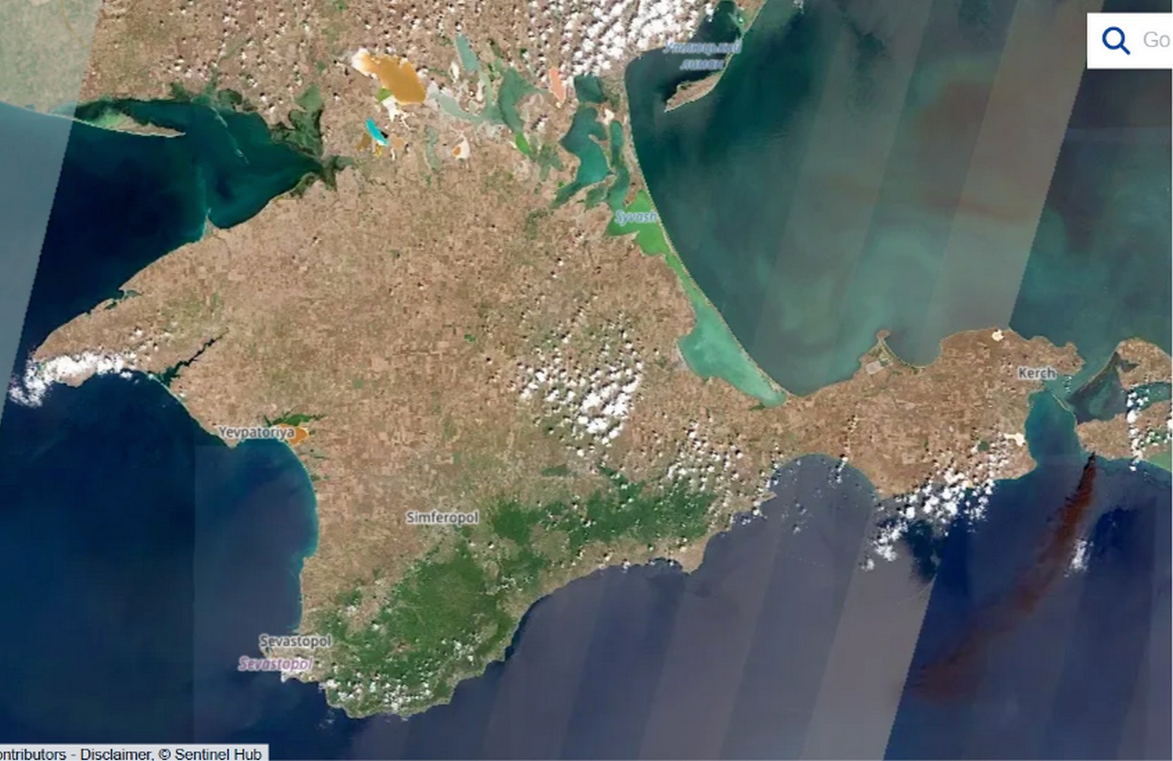
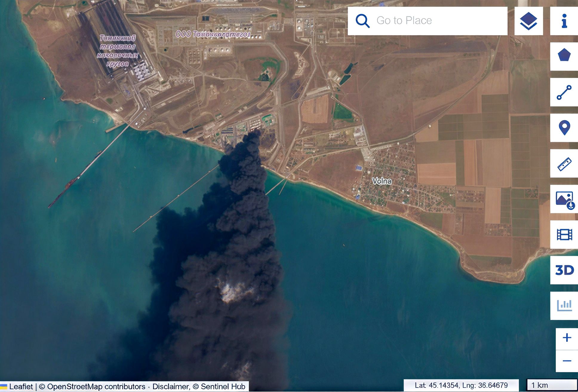
The Sentinel-2 optical image shows a dense, uniformly black, oily smoke column carried out to sea, with a visible plume length of roughly 100 kilometres on the 31 July frame by our own measurement. From there it is a matter of elimination. Vegetable oil does not ignite from a strike: its flash point exceeds 300 °C, and the smoke would in any case be pale. Hexane, the solvent used in oil extraction, flares black but burns off in minutes, whereas this fire ran for days. Biomass such as husk and meal burns unevenly, with a pale margin, not as an even black column. Once all three are ruled out, what remains is a steady, black, multi-day fire, and that is the signature of a stable hydrocarbon.

Sentinel-2: fire epicentre at Taman port with a dense black smoke plume
Photo 1. Sentinel-2 L1C, 31 July 2026. The fire epicentre. Uniform black smoke is the signature of burning petroleum products. Source: Sentinel Hub.
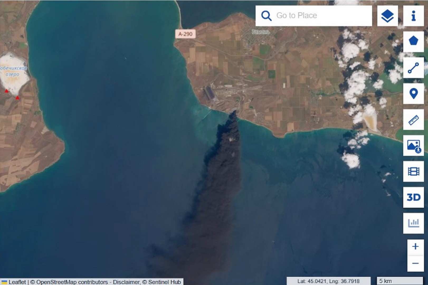
Sentinel-2 wide view of the black smoke plume extending from Taman port over the sea
Sentinel-2 regional view of smoke transport across the Kerch Strait area
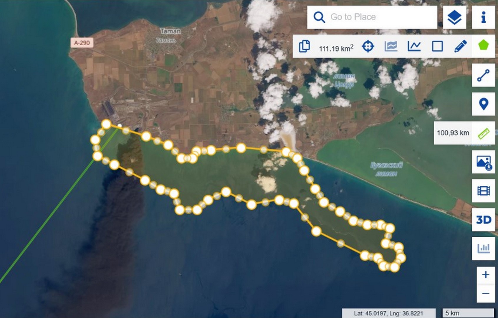
Sentinel-2 with a roughly 111 km² pollution bounding polygon and a roughly 100 km smoke plume measurement
Photos 2, 3, 5. Sentinel-2, 31 July 2026. Wide and regional views of the smoke; a polygon gives the bounding area of the early contamination (about 111 km²), and a ruler gives the plume length (about 100 km). Source: Sentinel Hub.

Oil does not burn: verified across eight cases

There is empirical support as well. «Zeleniy Lyst» has systematically documented strikes on oil infrastructure, and over two years there have been at least eight hits on vegetable-oil tanks in the ports of Pivdennyi and Chornomorsk. In none of them did the oil sustain a lasting black flame: it leaked, spread as a film, occasionally set nearby structures alight, but never produced an oily black column lasting days. We compiled the comparison in our satellite analysis of Operation Molochka.

Thermal signal: a fire that did not go out

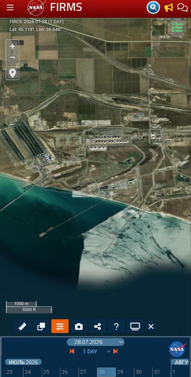
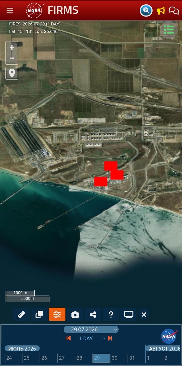
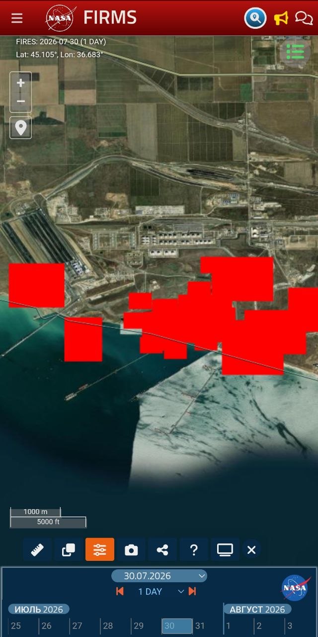
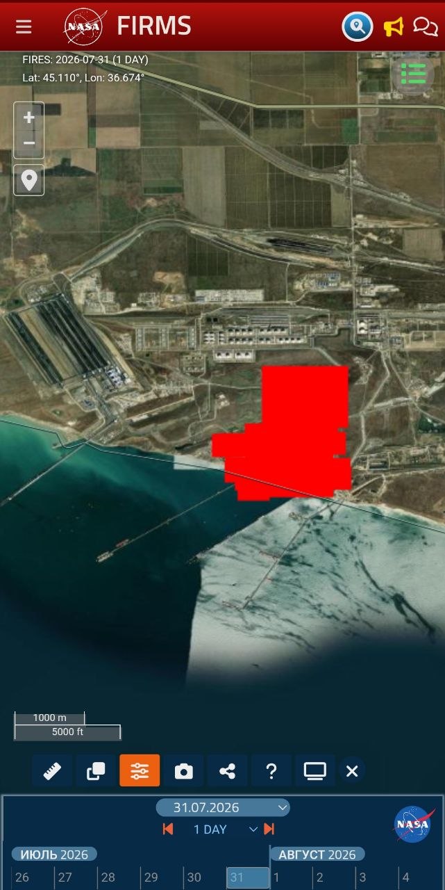
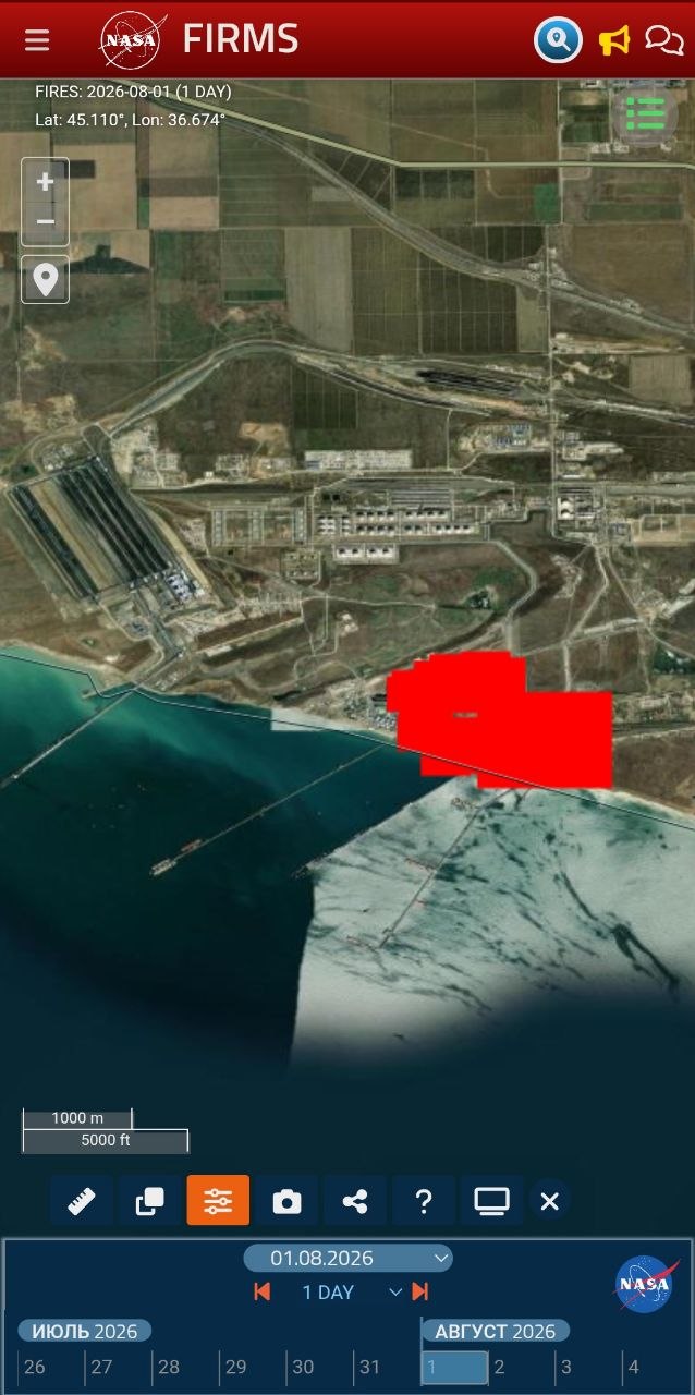
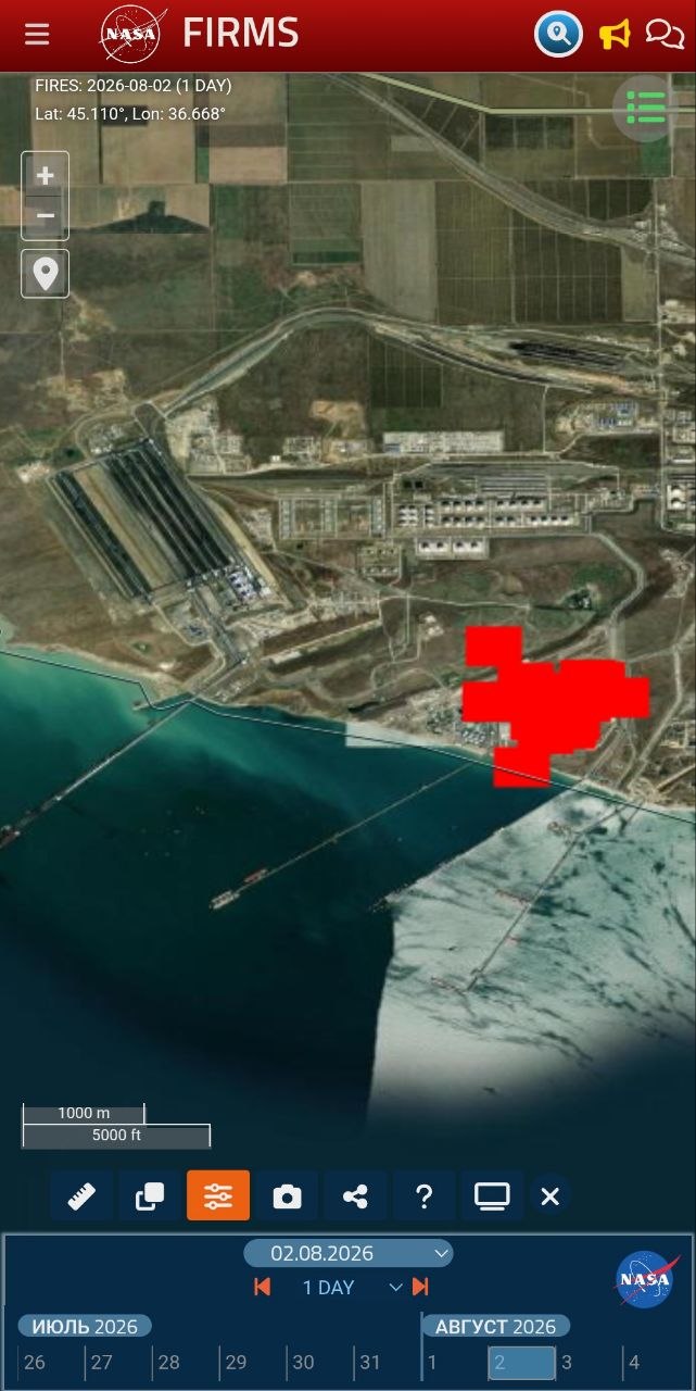
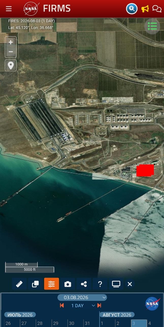
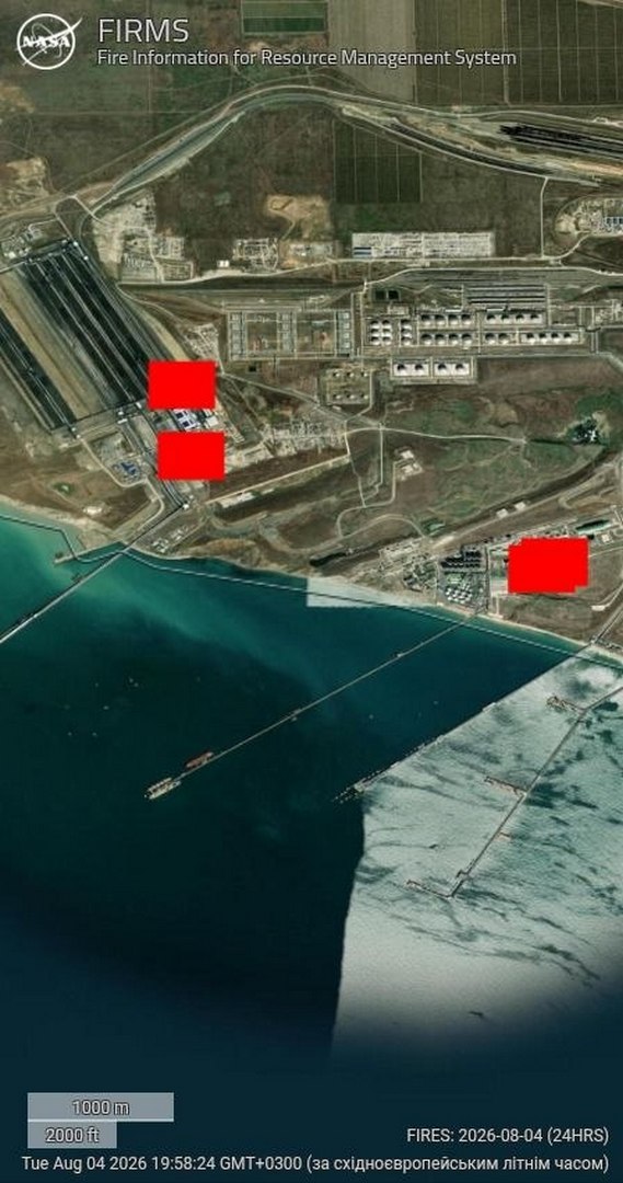
FIRMS records heat independently of smoke, and the picture from 28 July to 4 August is unambiguous. On 28 July it is clear, the pre-strike baseline. On the 29th isolated background detections appear, and on the 30th a dense cluster flares on the day of the strike. From 31 July through 2 August the signal holds at full strength; on 3 August the periphery burns down but the hotspot at the facility itself does not disappear, and on the 4th fresh detections appear around it. The essential point is that the plant’s own location burned without interruption throughout.

NASA FIRMS, 28 July 2026: pre-strike baseline
NASA FIRMS, 29 July 2026: isolated background thermal detections
NASA FIRMS, 30 July 2026: dense thermal anomaly cluster on the day of the strike
NASA FIRMS, 31 July 2026: strong thermal signal after the strike
NASA FIRMS, 1 August 2026: persistent thermal signal at the site
NASA FIRMS, 2 August 2026: continued persistent thermal signal
NASA FIRMS, 3 August 2026: site hotspot remaining after the periphery weakened
NASA FIRMS, 4 August 2026: new thermal detections around the hotspot
Photos 6–13. NASA FIRMS, 28 July — 4 August 2026. A continuous fire at the site: the hotspot is recorded every day, only the coverage area changes. The scatter of coordinates falls within FIRMS resolution (pixel about 375 m). Source: NASA FIRMS.

Vegetable oil does not burn for six days. Hexane burns off in minutes. Meal does not radiate heat like this. This is fuel, and it kept burning.

A civilian label on a military node

When a site is listed on every map as an oilseed processing plant, yet its hotspot burns without pause for six days and throws a hundred-kilometre black plume, this is no longer coincidence but tactic. Military logistics are hidden behind a civilian label so that a strike can be recast as a hit on “civilian infrastructure” or “on grain.” Two readings are possible and both point the same way: either the occupiers kept fuel under the guise of a civilian enterprise, using it as a shield, or it genuinely was an oil mill into which petroleum was piped for army needs. Either way this is the deliberate use of a civilian object for military purposes, itself a breach of international humanitarian law by the party that does it.

The cause should be named plainly. Russia is waging a war of destruction against Ukraine, and Ukraine, in defending itself, is entitled to strike the adversary’s military-logistics objects. The aggressor state has deliberately turned occupied Crimea and the Taman shore into a military-logistics complex, a fuel-supply node for the offensive, and placed it on the shore of a semi-enclosed sea, without secondary containment or visible safety measures, under civilian labels. Such a node carries a dual threat, military because it feeds the front and environmental because any damage to it sends product straight into the water, and responsibility for the environmental consequences rests with the side that built it this way and in this place.

Contamination on the water: spill dynamics

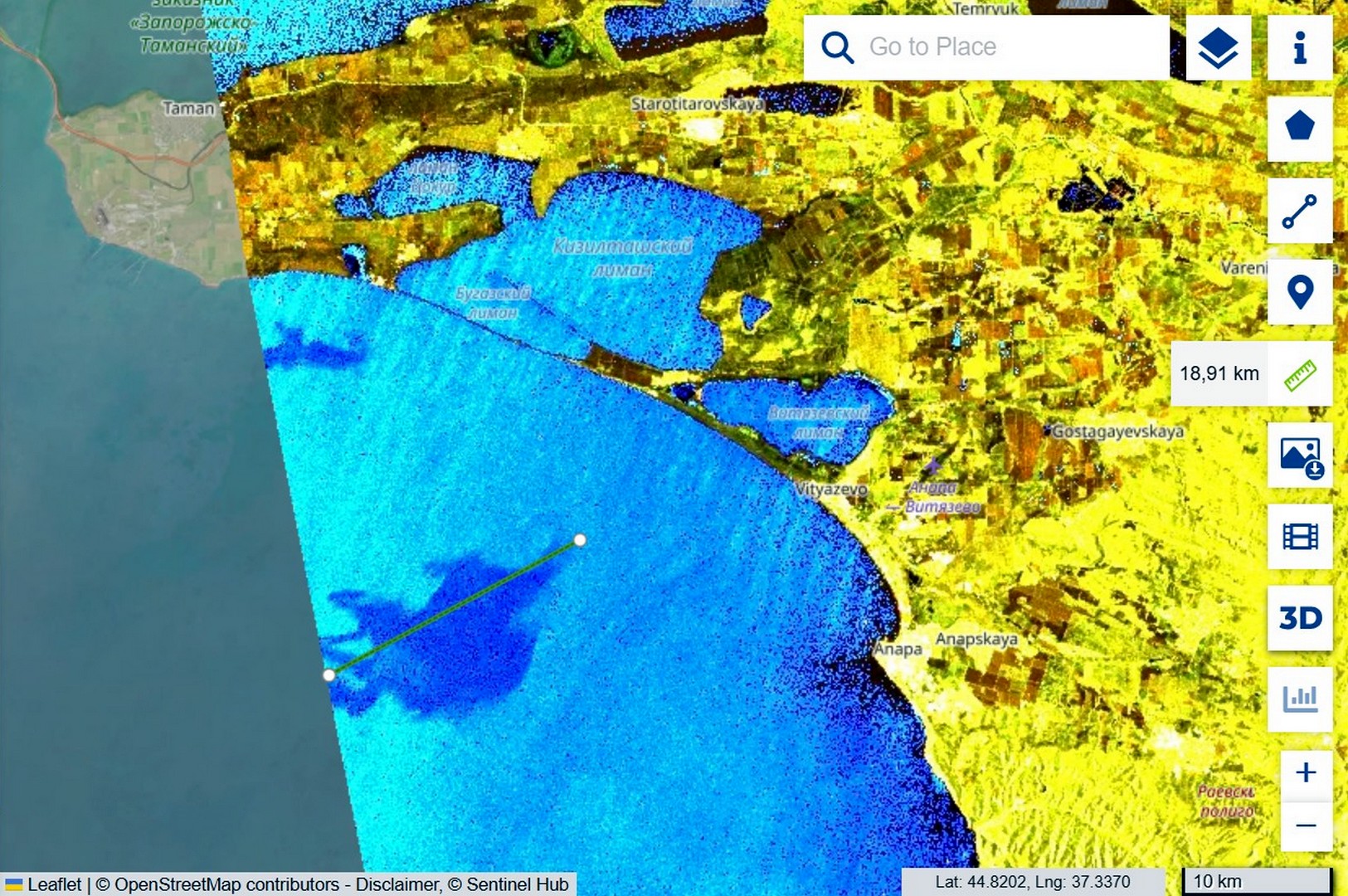
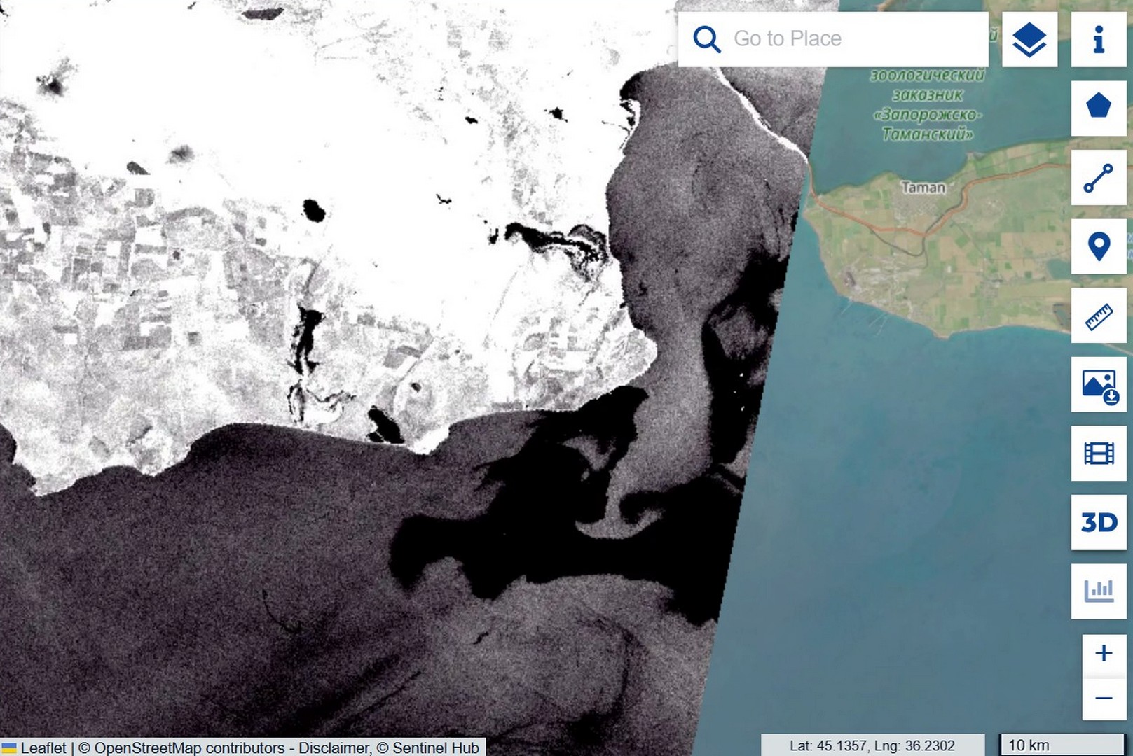
While Russian media spoke of grain and oil, the satellites were recording the actual slick, and doing so in two different ways. On the very first day the Sentinel-2 optical image of 31 July, captured under sun glint that reveals the film’s surface smoothing, allowed the early contamination to be outlined by polygon, yielding a bounding area of about 111 square kilometres. That figure must be read correctly: it is the area of the envelope, not a continuous film, because within it the product is scattered as separate fingers and streaks, and only a fraction of the water is actually covered. The slick was then tracked by Sentinel-1 radar, which detects the dampening of small waves even through cloud: on 1 August a compact plume 18.91 km long south of Taman, and on 4 August a tongue stretched to 40.44 km with vortex structures at the current boundary. The transport rate is roughly 7–8 kilometres per day, and the source was not a one-off, since fresh FIRMS hotspots on 4 August show that inflows continued.

Sentinel-2 sun glint: 111.19 km² pollution bounding area and about 100.93 km smoke plume
Photo 5. Sentinel-2, 31 July 2026, sun glint. A polygon gives the bounding area of the early contamination, 111.19 km²; a ruler gives the plume length, about 100.93 km. Source: Sentinel Hub.
Sentinel-1, 1 August: compact 18.91 km pollution plume south of Taman
Sentinel-1, 4 August: pollution tongue stretched to 40.44 km with vortex structures
Photos 14, 15. Sentinel-1 IW, 1 and 4 August 2026. Drift of the film from 18.91 km to 40.44 km over three days to the south-west. Source: Sentinel Hub.

Movement forecast: from Anapa to the Kerch peninsula

From 30 July to 2 August a north-easterly wind of 5–14 metres per second drove the film south-west, towards the coast of Anapa, and on 4 August it swung southerly and eased to 2–4 metres, so the outflow to open sea stopped and the contamination began to be drawn back towards the mouth of the strait. For the shorelines this means that at Anapa the risk persists on the shallows while new inflows cease, whereas the main threat shifts to the western shore of the Kerch peninsula, towards Kerch and on to Feodosia, where a weak southerly wind will draw the film. The exact heading beyond two or three days is hard to predict, because under a weak synoptic background the sea-breeze cycle takes over, onshore by day and offshore by night.

Update 5–8 August: the forecast held, and oil surfaced on the water

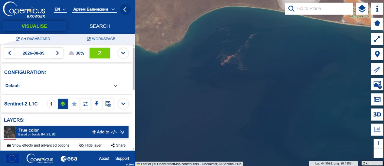
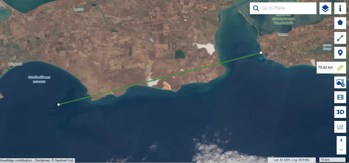
A few days after first publication new Sentinel-2 frames became available, confirming two of our conclusions and substantially strengthening a third. The drift forecast held: we wrote that once the wind reversed the contamination would be drawn along the western shore of the peninsula towards Feodosia, and that is what happened. On the 5 August image the slick is recorded along the southern shore, near the Opuk reserve and the Feodosia gulf, and on the 8 August frame the total transport length from Taman reaches 75.93 kilometres, against 40 four days earlier. The slick did not dissipate; it stretched along the coast exactly along the predicted scenario.

Sentinel-2, 5 August: contamination along the southern Kerch Peninsula near Opuk and Feodosia
Sentinel-2, 8 August: pollution transport extending 75.93 km from Taman
Photo 16. Sentinel-2, 5 August 2026. Contamination along the southern shore of the Kerch peninsula (Opuk, Feodosia). Photo 17. Sentinel-2, 8 August 2026. Transport length from Taman, 75.93 km. Source: Sentinel Hub.

The decisive point, however, is the nature of the light-coloured contamination. Along the shore a dense, form-holding yellowish structure is visible, not a thin iridescent sheen but thick emulsified ridges, and that is a diagnostic feature. Light petroleum products have low viscosity, spread into a thin film within minutes and give a silvery-iridescent sheen, but do not form dense ridges, having nothing to hold structure with. Fuel oil and crude, by contrast, are dark, because a thick layer absorbs light. Vegetable oil is viscous and emulsifies under wave action, forming a dense light phase resembling yellow sour cream, so a dense yellow ridge matches neither light petroleum products nor fuel oil and points to a viscous, emulsifiable substance, most probably vegetable oil.

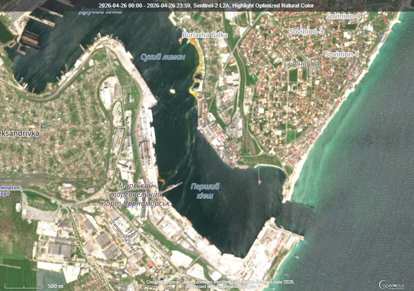
We have seen this same signature before. After the strike on Chornomorsk on 26 April 2026, where a confirmed sunflower-oil spill occurred, the water developed the same dense yellow emulsified structures, and the morphology matches.

Sentinel-2, 26 April 2026: dense yellow emulsified structures from the confirmed vegetable-oil spill near Sukhyi Lyman in Chornomorsk
Reference: Sentinel-2, 26 April 2026, Chornomorsk. Dense yellow emulsified structures of a confirmed oil spill near the shore (Sukhyi Lyman). Source: Sentinel Hub.

This is a morphological comparison of optical frames, not a spectral proof of substance identity, so “the same emulsified morphology, characteristic of vegetable oil” is a conclusion grounded in remote-sensing evidence rather than a substitute for laboratory confirmation.

What this means for the whole story is that the two accounts, the Russian one of oil and grain and the Ukrainian one of petroleum, stop being mutually exclusive, because the data show both, but separately, each by its own signature. Fuel burned, as the FIRMS heat and the black smoke attest, and alongside it, at a mixed terminal, there was oil that leaked on impact, did not burn as in the eight documented cases, and days later surfaced as light ridges along the coast. Not “either/or,” but “fuel burned and oil spilled,” with each component proven by its own independent signature.

What comes next. On the imagery the yellow emulsified ridge is effectively already within the Feodosia gulf, and the Feodosia shore is not far from there. The wind is carrying it precisely that way, so in the coming days the oil should appear along the Feodosia coast and adjacent stretches of the southern Crimean shore. This is no longer a distant forecast but a matter of a few kilometres and a few days.

Consequences for the marine environment

The facility sits on the shore, right at the waterline, without secondary containment or visible engineering barriers, so any damage to the tanks sends product straight into the sea. This occurs in a sensitive body of water: the Black Sea is anoxic below 150–200 metres, living benthos exists only on a narrow strip of shelf, and additional loading presses it against the hydrogen-sulphide boundary. The area’s benthic filter feeders, mussels, polychaetes and small crustaceans, are also the forage base for commercial fish, so damage to the bottom propagates through the whole food chain.

Petroleum products and vegetable oil act differently, and this matters for assessing the consequences. Petroleum products carry carcinogenic toxicity through polycyclic aromatic hydrocarbons; part evaporates, the rest settles. Vegetable oil has no carcinogenic properties but behaves more insidiously: in summer, under ultraviolet light and in warm water, it polymerises, hardening into a dense benthic cap almost impermeable to oxygen. According to NOAA, such polymerised oil persists on the bottom for more than six years; without polymerisation it would biodegrade within half a year, but the Taman strike occurred at the height of summer, in conditions that guarantee polymerisation. Storm-driven resuspension returns the sediment to the water column season after season. For birds the oil is more dangerous than fuel oil, because it disrupts feather microstructure so that washing cannot restore it, and by our field observations after the December 2025 spill no more than five percent of the birds counted as rescued actually returned to the wild. A detailed treatment of these mechanisms, with references to the scientific literature and field data, is given in our report on the third oil spill in Odesa Bay.

The consequences are not local. Currents carry the contamination along the coast into the open Black Sea, where the cyclonic circulation spreads it over hundreds of kilometres, or northward through the strait into the shallow, spawning-ground Sea of Azov. Fuel oil from the Volgoneft wrecks in this same waters was recorded in the Tuzly Lagoons near Odesa, over 650 kilometres away, and every new accident is layered on the previous ones while the sea cannot process the load. Our field confirmations are compiled in the Tuzly Lagoons research and on the Environmental Evidence Platform.

In lieu of conclusions: what is established, what remains open

Established by direct observation and instruments: a continuous multi-day fire at the site from 30 July to 4 August (FIRMS); early film contamination of about 111 km² and a smoke plume of about 100 km (Sentinel-2); drift of the film from 19 to 40 km (Sentinel-1) and on to 76 km as of 8 August; that fuel burned rather than agricultural produce, along three independent lines; that the light contamination shows an emulsified morphology characteristic of vegetable oil, matching the reference spill at Chornomorsk; and that the drift forecast along the Kerch peninsula held.

What remains hypothesis is the specific fuel type and the reason for its presence at a civilian-labelled site, the exact area of continuous film since the satellite gives only the envelope, the trajectory beyond two or three days since current data are required, and the full extent of harm to biocenoses without field verification, because there is no access to the occupied shore.

Sources and data

  1. Sentinel-1, Sentinel-2 — ESA / Copernicus (Sentinel Hub).
  2. NASA FIRMS — thermal anomalies, 28 July — 8 August 2026.
  3. Surface weather observations, Opasne station; ECMWF forecast.
  4. Persistence of vegetable oil on the seabed — NOAA, Non-Petroleum Oil Spills.
  5. Methodology: DOI 10.20535/EHS2710-3315.2025.332100.
  6. Statements by the parties are given per official communications and require verification against primary sources.

Author: Vladyslav Balinskyi, editor-in-chief, «Zeleniy Lyst». Satellite data: ESA/Copernicus. Thermal data: NASA FIRMS. This is an analytical material; factual claims are kept separate from hypotheses.

ByVladislav Balinsky

Sinking of Golden Leo: Environmental Risks in the Black Sea

Environmental monitoring · Odesa Bay · July 2026

The loss of Golden Leo is not an isolated maritime casualty. It adds another layer of pressure to waters already affected by the destruction of the Kakhovka Dam, heavy-fuel-oil pollution and wartime attacks. Fuel, bilge water, a cargo of corn and an unstable hull may act at the same time—at the surface, near the seabed and within marine sediments.


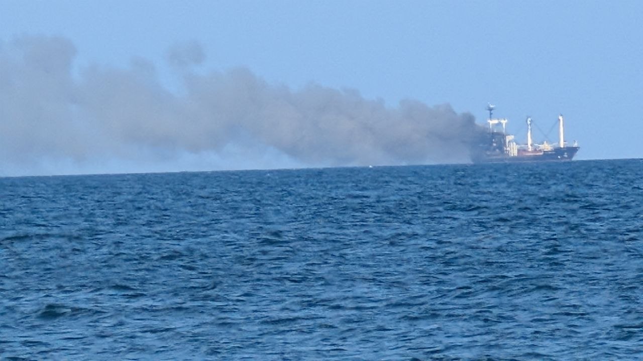
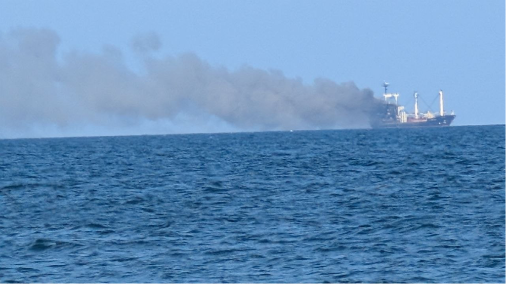
Golden Leo trailing smoke after a Russian missile strike in the Black Sea on 19 July 2026
Golden Leo after a Russian missile strike in the Black Sea on 19 July 2026. Photo: Vladyslav Balinskyy.

War is changing the Black Sea not only through explosions, but through processes whose effects may persist for years. The destruction of the Kakhovka Dam, heavy-fuel-oil pollution following the casualty involving Russian tankers in the Kerch Strait, sunken vessels and attacks on civilian shipping are creating an interconnected system of risk.

Golden Leo adds another potential source of pressure roughly five nautical miles off Odesa, in shallow coastal waters strongly influenced by wind-driven circulation.

For Odesa Bay, the sinking of Golden Leo is not only a human tragedy but a new source of long-term environmental risk. A large wreck containing fuel, technical fluids and a cargo of corn may affect surface waters, bottom waters, seabed sediments and the safety of navigation.

What happened

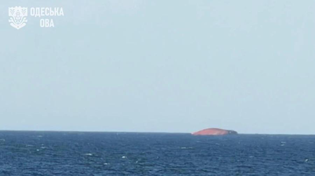
On 19 July, the Guinea-Bissau-flagged merchant vessel Golden Leo, carrying Ukrainian corn, came under a Russian missile attack while leaving the port of Chornomorsk through Ukraine’s maritime corridor. Ten people were killed—nine crew members and a Ukrainian maritime pilot. After several days of damage-control efforts, the vessel was no longer seaworthy and sank on 26 July, approximately five nautical miles off the Odesa coast.


Golden Leo almost completely submerged off the Odesa coast on 26 July 2026
Golden Leo sinking off the Odesa coast on 26 July 2026. Photo: Odesa Regional Military Administration.

Among the many Odesa residents who witnessed the disaster was Vladyslav Balinskyy, a researcher at Tuzly Lagoons National Nature Park and head of the Odesa branch of the National Ecological Centre of Ukraine.

“The ship was struck in three successive missile attacks. After the first hit, the Russians waited roughly seven or eight minutes—the very period when pilot boats, emergency responders and other support craft would normally approach a damaged vessel. A second strike followed, and then a third,” Balinskyy says.

Three successive strikes on a civilian vessel turned an immediate human tragedy into a long-term engineering and environmental problem.

Golden Leo and a smoke plume over the sea after successive Russian missile strikes on 19 July 2026
Golden Leo after the attack. Photo: Vladyslav Balinskyy.

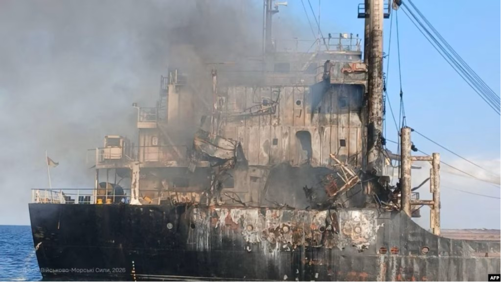
The damaged and smoking superstructure of Golden Leo after the Russian missile strike on 19 July 2026
Damage to Golden Leo after the Russian strike on 19 July 2026. Photo: Ukrainian Navy.

Attacks on civilian shipping have become systematic

Since spring 2026, Russia has sharply intensified attacks on civilian shipping in the Black Sea. According to Ukraine’s Deputy Prime Minister for Restoration, Oleksii Kuleba, more than 70 attacks on merchant vessels had been recorded since the beginning of the year.

According to the Odesa Regional Prosecutor’s Office, 28 civilian vessels were hit in the ports of Greater Odesa in just one month, from the second half of June to the second half of July. Twenty-six were foreign-flagged and two were Ukrainian. The attacks killed 21 people and injured another 34.

Among the first documented incidents of 2026 was a strike on 18 May against a Marshall Islands-flagged merchant vessel owned by a Chinese shipowner. On 29 May, the Vanuatu-flagged bulk carrier ANT was hit while leaving a port in Odesa region for Türkiye. A fire broke out on board and two crew members were injured.

On 22 June, Russia carried out another attack on civilian vessels in the Black Sea. At least three merchant ships flying the flags of Panama, Vanuatu and China were struck. A cook from Egypt was killed on one vessel, while eight other seafarers had to abandon ship in a life raft.

The pace of attacks rose sharply in July. Within a single week, vessels flying the flags of Saint Kitts and Nevis, Togo, Tanzania, Liberia, the Marshall Islands, Antigua and Barbuda, Palau and other states were reported hit. Some vessels were attacked more than once.

The 19 July strike on Golden Leo became the culmination of that escalation.

Several days earlier, on 13 July, the International Maritime Organization formally condemned a series of attacks on civilian merchant vessels in the Black Sea and the Sea of Azov and called for attacks on international shipping to stop.

On 23 July, Ukraine’s Ministry of Agrarian Policy reported that the sharp rise in Russian attacks had prompted shipowners to temporarily suspend calls at Ukrainian Black Sea ports.

On 27 July, the UN Security Council held an emergency meeting on the safety of civilian shipping in the Black Sea. According to the UN, more than 40 crew members were killed or injured in attacks on civilian vessels during July alone.

The rising threat has already disrupted maritime logistics. Lloyd’s List Intelligence described operating conditions as the worst since the Black Sea Grain Initiative ended in 2023. Insurance premiums and freight rates increased, while some international operators, including Maersk, temporarily suspended selected Ukrainian services because of the security situation.

Two very different approaches to warfare at sea

Balinskyy argues that the Golden Leo case exposes a fundamental distinction between military operations designed to disrupt an opponent’s logistics and attacks directed at civilian shipping.

Ukraine’s Unmanned Systems Forces conducted Operation Molochka from 6 to 28 July with the aim of cutting fuel-supply routes serving Russia’s southern military grouping.

Russia used occupied Crimea as a transport and logistics hub. Across the Sea of Azov, small tankers and cargo vessels of the Volgoneft, Volgobalt and related designs regularly moved substantial quantities of fuel and lubricants. The existence of that transport system in itself posed a potential threat to the ecosystems of the wider Black Sea–Azov basin.

A detailed satellite-based assessment is available in the Green Leaf investigation “201 Vessels Hit—but Not 201 Fires: Satellite Analysis of Operation Molochka”.

Reflecting on the environmental consequences of Operation Molochka, Balinskyy says:

“Ukraine’s objective was to shut down this logistics network, but to do so as precisely as possible. During the period we analysed, from 6 to 27 July, we found no evidence of widespread ship fires or large-scale releases of petroleum products into the sea. Although 129 vessels operated in the segment we examined, and more than two hundred were active across the wider Black Sea–Azov basin, we observed only two comparatively long-lasting fires and several local fuel leaks. At the same time, the logistics system itself effectively ceased to function.”

In his view, the attack on Golden Leo followed a fundamentally different logic.

Balinskyy’s assessment is that the objective was not simply to disable the vessel, but to maximise loss of life, destroy a civilian ship and create long-term risks for maritime transport and the marine environment.

“The warhead of a cruise missile is incomparably more powerful than that of an attack drone and may contain around 300 kilograms of explosive. The attack killed ten people, critically damaged the vessel and ultimately caused it to sink. Beyond the human tragedy, it created potential environmental risks that now require long-term monitoring and scientific assessment,” Balinskyy says.

After the vessel went down, the Odesa Regional Military Administration convened an emergency meeting of its commission on technological and environmental safety.

The commission introduced continuous monitoring of the Black Sea area to assess potential effects on the environment and on navigation safety.

Authorities are paying particular attention to possible leaks of fuel and lubricants into the sea.

But is surface surveillance alone enough to evaluate all the environmental consequences of a large merchant ship lying on the seabed?

Potential sources of pollution

In this context, the sinking of Golden Leo presents serious environmental risks for the north-western Black Sea and Odesa Bay. The effects are likely to remain local, but local does not mean insignificant. Odesa Bay is shallow and partly enclosed, and its water circulation depends heavily on wind direction and strength. Under certain weather and sea conditions, pollutants from the wreck site could be carried towards the coast.

The main potential sources of contamination are fuel, lubricants, hydraulic fluids, other technical substances and bilge water. Large bulk carriers have complex networks of fuel tanks, pipelines and machinery spaces that may retain considerable quantities of petroleum products after a casualty. Preliminary estimates suggest that a vessel of this class might have carried anything from several dozen tonnes to roughly 100–150 tonnes of heavy marine fuel. The actual amount can be established only from the ship’s documentation.

Bilge water poses a separate hazard. It is a mixture of water, fuel, lubricants and other technical fluids that accumulates in machinery spaces. If released, it can become another source of toxic contamination.

Surface waters

Fuel, lubricants and technical fluids may form films or slicks whose movement will depend largely on wind, waves and surface currents.

Bottom waters

Decomposition of the organic cargo may consume dissolved oxygen, alter local water chemistry and create oxygen-depleted conditions near the seabed.

Seabed sediments

Petroleum products and decomposition residues may accumulate in sediments and later be released during storms or if the wreck shifts.

The wreck itself

Instability, corrosion and storm loading may open new leakage pathways even when no visible contamination is present at the surface.

“Each individual object may have only a local effect, but the combined impact of many such sources is complex, cumulative and largely unpredictable,” Vladyslav Balinskyy says.

How a cargo of corn can affect the marine ecosystem

The ship’s cargo also requires attention. Corn is a natural material, but a large mass of organic matter concentrated in one place can still alter the marine environment. Some grain has reportedly been found on the shore of Odesa Bay, while most of the cargo is thought to remain inside the holds.

When large quantities of grain remain submerged, they can swell, ferment and gradually decompose. These processes consume dissolved oxygen, potentially creating local oxygen-depleted zones and changing conditions near the seabed. Anaerobic decomposition may also generate gases and organic compounds that affect benthic ecosystems.

At least two different impact pathways may therefore operate at the same time: surface contamination from possible fuel and lubricant leaks, and near-bottom changes caused by the decomposition of organic cargo. Their development will depend on weather, currents and local circulation.

Why an underwater survey is essential

Balinskyy says the immediate priority should be a detailed underwater survey of the wreck. Investigators need to determine how the hull is resting on the seabed, whether it is stable, whether autumn and winter storms could shift or break it apart, and what condition the fuel tanks, pipelines, access hatches and damaged sections are in.

Only then will it be possible to decide whether the hull needs to be sealed, whether fuel and bilge water should be pumped out, whether the wreck requires additional stabilisation, or whether other engineering measures are necessary. The site also needs clear navigational marking and long-term structural monitoring.

The feasibility of removing the corn requires a separate technical assessment. That decision depends on the vessel’s position, the condition of the holds, the extent of structural damage and whether the cargo can be reached safely.

Immediate questions that need answers

  • How the hull is positioned and whether it is stable at a depth of about 20 metres;
  • The condition of fuel tanks, pipelines, access hatches and breaches;
  • Whether the wreck can be sealed and fuel or bilge water pumped out;
  • The condition of the holds, the distribution of the corn and whether the cargo can be reached safely;
  • Whether the hull needs stabilisation, navigational marking and long-term structural monitoring.

War is creating a new human-driven regime in the Black Sea and the Sea of Azov

Golden Leo is only one example of the environmental consequences of Russia’s full-scale war at sea.

Since the full-scale invasion began, the Black Sea and the Sea of Azov have become active theatres of war. Missile strikes on port infrastructure, attacks on civilian shipping, mined sea routes, sunken vessels, fuel leaks, destroyed hydraulic structures and the constant presence of military hardware are creating new forms of pressure on marine ecosystems.

Among the largest environmental shocks of recent years are the destruction of the Kakhovka Dam, which sent enormous volumes of organic matter, pollutants and sediments from the Dnipro basin into the Black Sea; the casualty involving Russian tankers in the Kerch Strait, which caused extensive heavy-fuel-oil pollution; and repeated attacks on civilian vessels using Ukraine’s maritime corridor.

Balinskyy argues that these events cannot be assessed in isolation.

“Existing damage is now being compounded by newly sunken vessels and by fragments of missiles and drones entering the marine environment. All of these objects may release petroleum products, metals, polymers and other pollutants. We are not dealing with separate incidents, but with accumulating pressures that must be studied as one system.”

In his assessment, the full-scale war has created an entirely new human-driven operating regime in the Black Sea. Before 2022, the main pressures were river runoff, shipping, agriculture, industrial pollution, eutrophication and climate change. They have now been joined by sunken vessels, missile and drone debris, munitions, damaged hydraulic infrastructure, fuel leaks and the large-scale movement of contaminated sediments.

Each pressure may appear local when considered alone. But currents, waves, storms and sediment transport connect them into a single system in which the effects of different events accumulate, interact and may emerge months or even years later.

“That is why responding to individual pollution incidents is no longer enough. We need to understand how the Black Sea ecosystem is changing as a whole and how different sources of pressure interact,” Balinskyy says.

The same cumulative pattern is visible in field research along the coast of Tuzly Lagoons National Nature Park, where scientists are documenting heavy fuel oil, fragments of Russian aerial systems and the deaths of marine mammals at the same time.

From isolated incidents to systematic monitoring

Golden Leo again shows that dealing with the immediate aftermath of an accident is not enough. Environmental damage must also be documented systematically—for scientific assessment, future damage calculations, international investigations and the restoration of marine ecosystems.

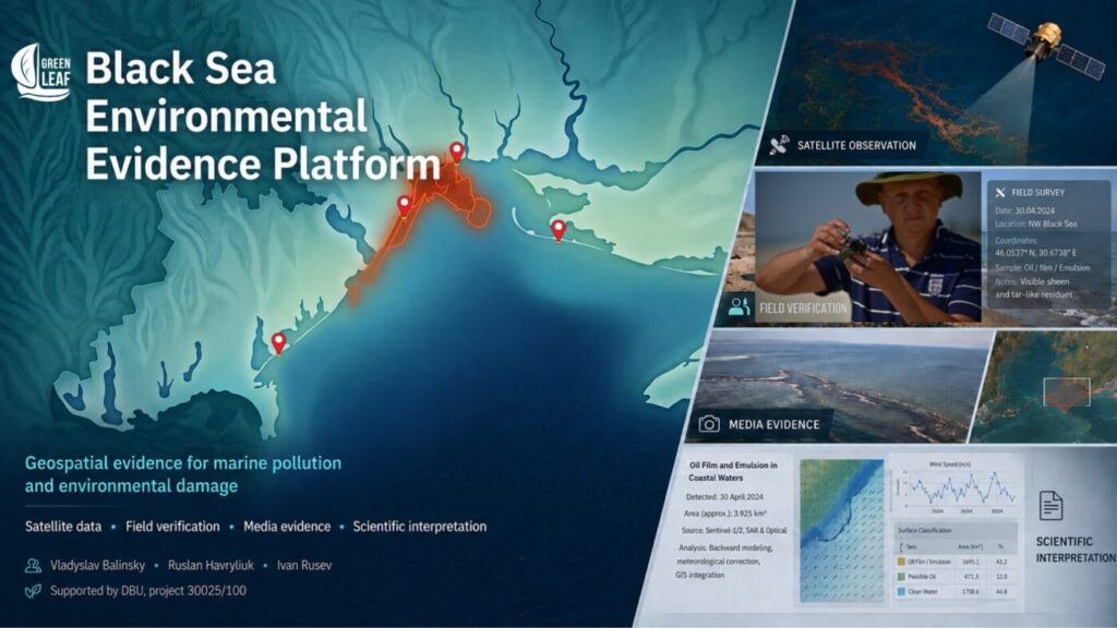
To support that work, the non-governmental organisation Green Leaf, together with scientists from Tuzly Lagoons National Nature Park, developed the Black Sea Environmental Evidence Platform. It brings together Sentinel satellite data, field observations, laboratory analysis and photographic records. Each entry preserves coordinates, observation dates, sources, verification methods and scientific caveats.


The Black Sea Environmental Evidence Platform combining mapped incidents, satellite data and field verification
The Black Sea Environmental Evidence Platform brings together satellite data, field verification, media evidence and scientific interpretation.

The Platform does not determine legal responsibility. Its purpose is to preserve verifiable evidence that may support environmental assessments, damage evaluation and international legal proceedings.

The system has already been tested while documenting the Volgoneft tanker casualty and vegetable-oil spills in the ports of Pivdennyi and Chornomorsk. It can also be used to record the consequences of the sinking of Golden Leo, attacks on civilian vessels, marine pollution and other wartime incidents.

Balinskyy believes that Black Sea monitoring should become a continuous observation system combining satellite surveillance, field research, analysis of water and sediments, and structural monitoring of wrecks and other technological hazards.

Unlike water samples, which capture conditions only at the moment they are collected, sediments accumulate petroleum products, heavy metals, microplastics, organic pollutants and other substances over long periods. Storms, dredging and other natural or human-driven processes can release those contaminants back into the water, turning the seabed into a secondary source of pollution.

Monitoring around Golden Leo should therefore extend far beyond looking for visible oil slicks. It should include bottom-water and sediment sampling, measurements of petroleum hydrocarbons, organic matter and dissolved oxygen, and repeated observations around the wreck over an extended period.

Only this kind of integrated approach can assess more than the consequences of a single casualty. It can also help explain how war is gradually changing marine ecosystem function and creating new long-term risks across the Black Sea and the Sea of Azov.

Monitoring Golden Leo must not end with a search for an oil slick. It should track the hull, surface and bottom waters, dissolved oxygen, organic matter, petroleum products and seabed sediments across seasons and storm cycles.

Sources and related reading

  1. National Ecological Centre of Ukraine — the original Ukrainian publication by Tetyana Herasymova on which this adapted edition is based.
  2. National Ecological Centre of Ukraine — background on the long-term effects of the destruction of the Kakhovka Dam on the Black Sea.
  3. National Ecological Centre of Ukraine — background on heavy-fuel-oil pollution following the casualty involving Russian tankers in the Kerch Strait.
  4. USM — reporting on the attack against Golden Leo and the circumstances of the incident.
  5. Reuters — reporting on the vessel’s loss on 26 July 2026.
  6. Ministry for Communities and Territories Development of Ukraine — the reported number of attacks on merchant vessels since the beginning of 2026.
  7. Radio Free Europe/Radio Liberty, Ukrainian Service — figures from the Odesa Regional Prosecutor’s Office on vessels hit, fatalities and injuries.
  8. International Maritime Organization — statement on attacks against civilian shipping in the Black Sea and the Sea of Azov.
  9. Latifundist — reporting on the temporary suspension of vessel calls at Ukrainian ports.
  10. USM — reporting on the emergency UN Security Council meeting on attacks against shipping.

Related articles from Green Leaf

Editorial note. This is an English editorial adaptation of the Ukrainian article published by the National Ecological Centre of Ukraine. The title, introductory framing, structure, visual presentation and links to the Green Leaf series were adapted for an English-language audience; the author’s reporting and the expert assessments were preserved.