Vladyslav Balinskyy — Chemist, Biologist, Editor-in-Chief of the Online Media “Green Leaf”
Academic Supplement to the Series of Materials on the Environmental Consequences of Fires in Oil Infrastructure
Introduction
The events in the Kerch Strait area in June 2026 are examined here as a case study of the environmental consequences of damage to transport-logistics and fuel infrastructure. The analysis integrates satellite monitoring (Sentinel-2), meteorological data on the direction and behavior of air mass transport, and information from open sources. Emphasis is placed on the spatial distribution of combustion sources, smoke plume configuration, the likely combustion behavior of petroleum products, and the potential linkage between the atmospheric phase of pollution and the Azov-Black Sea basin.
Some aspects are considered within the author’s broader framework for analyzing the spatially interconnected environmental consequences of war.
1. The Event and Affected Infrastructure
1.1. Chronology of the Event
On the night of June 21, 2026, according to open sources, objects of the transport-ferry and fuel infrastructure in the Kerch Strait area were struck. The subsequent development of the event was accompanied by a large-scale fire that produced an extensive smoke plume detectable by Earth remote sensing.
The primary source of spatial data is Sentinel-2 satellite imagery acquired after the event. Cloud cover over parts of the water area and adjacent land introduces some limitations for interpretation but does not prevent identification of the main combustion sources or the plume configuration.
1.2. Spatial Structure of the Atmospheric Signal
Sentinel-2 imagery acquired after the event shows one powerful combustion source generating an extended smoke plume oriented toward the Taman Peninsula. The plume’s alignment generally follows the Kerch–Taman axis and the configuration of the Crimean Bridge crossing.
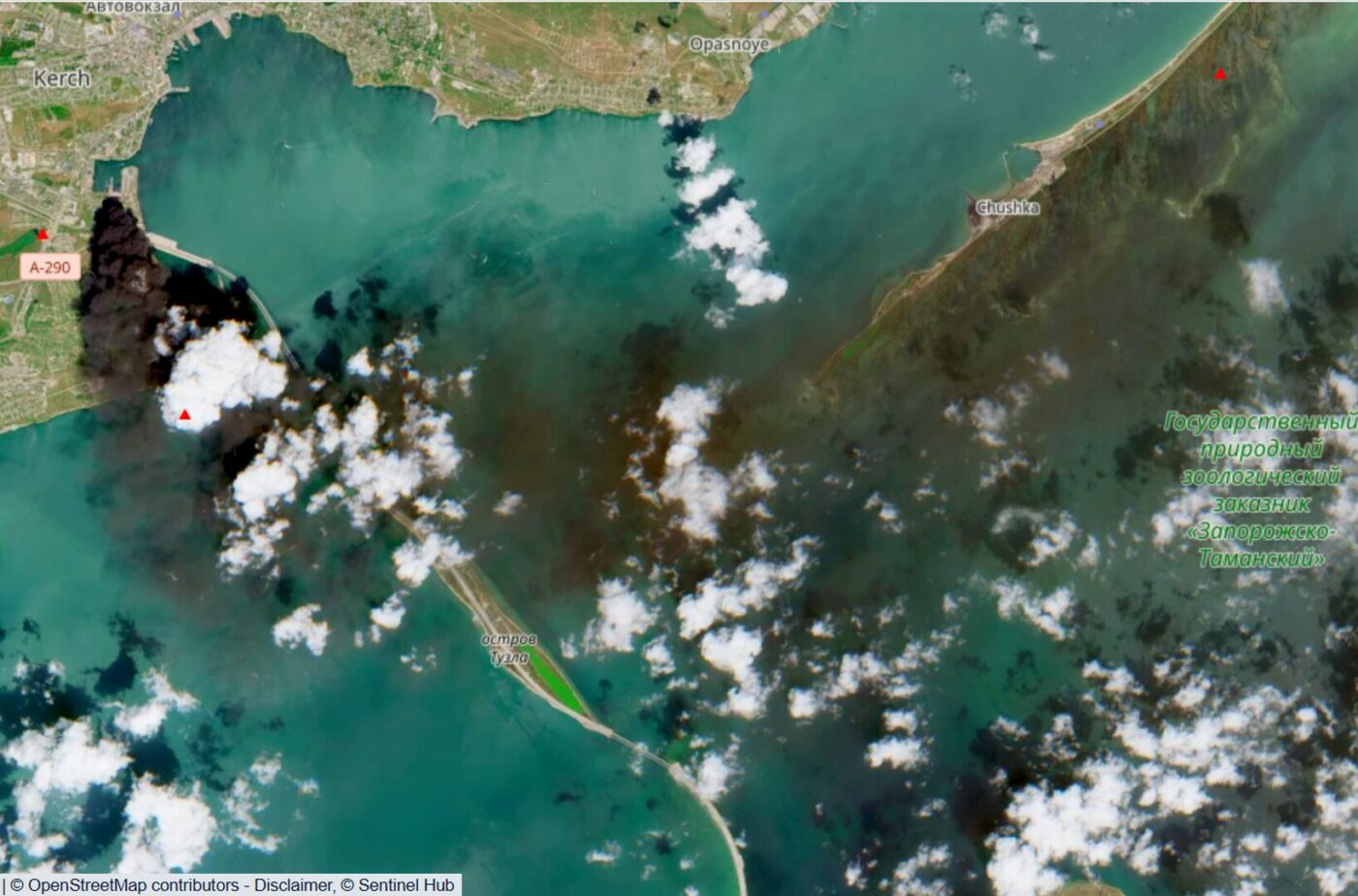
A much broader zone of atmospheric darkening is visible over Kerch Bay, whose area visually exceeds that of the main smoke plume. Its nature cannot be determined unambiguously from available data.
Possible explanations include accumulation of combustion products in the lower surface layer of the atmosphere or their interaction with low cloud cover. The contribution of other combustion sources that may have been active before the satellite overpass cannot be ruled out. A further hypothesis—one that cannot be dismissed based on single-channel RGB imagery—is the presence of surface contamination or altered optical properties of the water (oil slick, increased turbidity). With these data, distinguishing between atmospheric and near-surface aquatic effects is impossible without additional spectral or instrumental measurements.
For now, the atmospheric manifestations of the event can be preliminarily described as a system of at least two spatially distinct components: an active smoke plume from the main source and a more diffuse pollution zone over the Kerch Bay water area.
1.3. Location of the Main Combustion Source
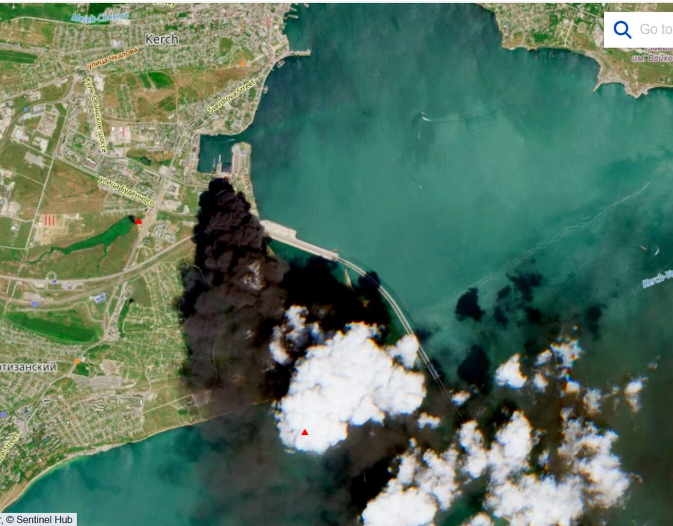
At the time of the satellite overpass, the main intense combustion source was located in the area of the transport-ferry and adjacent fuel infrastructure of the Kerch hub. A pronounced smoke plume extended from it toward the Taman Peninsula, following the general alignment of the Kerch Strait.
Based on visual evidence, this was the dominant source of atmospheric emissions at that moment. However, available data do not confirm whether the recorded pattern corresponds to all combustion sources that appeared during the event. Some sources may have ceased active burning by the time of the satellite overpass, or remained beyond the limits of visual identification.
1.4. Spatial Heterogeneity and Thermal Anomalies
Unlike Sentinel-2, which captures a single moment, FIRMS data (NASA) aggregate thermal anomalies over 24-hour periods and indicate several sources of elevated thermal activity distributed across the Kerch Strait area and adjacent territories.
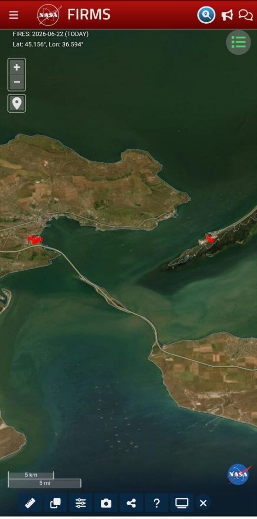
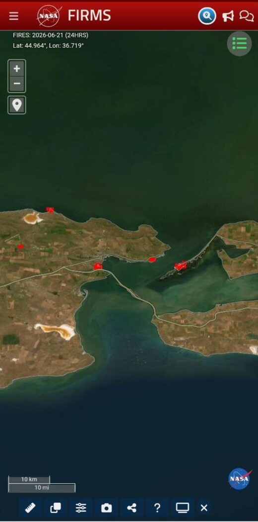
This suggests that the Sentinel-2 pattern reflects not only the current state of the main source but also the cumulative effect of a more complex spatio-temporal structure—including the possibility that the extensive darkening zone over the water area resulted from the combined contribution of multiple sources active at different times. Reconstructing their sequence is impossible from available data; therefore, further analysis proceeds from the assumption of a spatially heterogeneous event.
1.5. Preliminary Identification of Affected Objects
Combined analysis of Sentinel-2, FIRMS thermal anomalies, and open sources suggests that the event was centered on the transport-ferry and fuel infrastructure of the Kerch hub. The spatial distribution of thermal signatures indicates that it was not confined to a single local source but likely encompassed several functionally linked facilities.
Potentially affected objects include elements of the transport-ferry complex and storage, transshipment, and supply facilities for fuels and lubricants. Available materials do not allow assessment of the degree of damage to individual structures; the analysis therefore focuses on spatial localization and functional significance rather than on the extent of destruction.
1.6. Limitations of Satellite Observations and Interpretation Uncertainties
The analysis relies primarily on remote sensing data, meteorological information, and open sources. This approach enables localization of combustion sources, assessment of plume configurations, and detection of thermal anomalies, but it has significant limitations.
The absence of instrumental atmospheric composition measurements, data on the actual composition of combustion products, and restricted access to the event area preclude quantitative assessment of pollution scales and verification of some interpretations.
Nevertheless, satellite observations, meteorological data, and atmospheric modeling can support interpretation of the event’s spatial structure and potential pollutant transport directions. The conclusions presented here are therefore based on available data and require further verification through instrumental observations and specialized transport and transformation models.
2. Military-Logistical Significance of the Kerch Hub
The Kerch Strait is one of the key transport hubs in the Azov-Black Sea region. Transport crossings, ferry infrastructure, fuel facilities, and auxiliary coastal structures form an integrated logistics system here, where the significance of individual elements is defined not only by their own characteristics but also by their role within the overall complex.
System resilience depends on multiple complementary transport mechanisms and the capacity for partial redistribution of traffic flows in case of disruption to individual components. The transport-ferry infrastructure therefore functions not in isolation but as part of a redundancy and resilience mechanism.
Transport functions are inseparable from the fuel supply system. Storage and transshipment facilities for petroleum products are not separate from transport infrastructure but its functional extension. The spatial proximity of transport and fuel facilities in the Kerch Strait area reflects not accidental adjacency but the functional integration characteristic of major logistics hubs.
A distinctive feature of such systems is the combination of civilian and military functions. Dual use is a property not of individual structures but of the transport and material flows passing through them. The same transport crossings, ferry complexes, and fuel facilities can support movement of both civilian cargo and military equipment and resources. System functioning thus depends not on the design features of individual elements but on the structure of logistics flows under specific conditions.
High functional integration is simultaneously a source of resilience and vulnerability. Spatial concentration of transport, fuel, and auxiliary functions increases logistics efficiency but, in case of damage to individual components, creates conditions for the spread of consequences to adjacent facilities and the environment.
The Kerch hub thus represents a spatially integrated transport-fuel system, whose efficiency, resilience, and vulnerability are defined by the nature of interconnections among its components.
3. Dual-Use Infrastructure and International Humanitarian Law
3.1. The Principle of Distinction and Military Necessity
A fundamental principle of international humanitarian law is the distinction between civilian objects and military objectives. Under Article 52 of Additional Protocol I to the Geneva Conventions, military objectives are limited to objects which by their nature, location, purpose, or use make an effective contribution to military action and whose total or partial destruction, capture, or neutralization, in the circumstances ruling at the time, offers a definite military advantage.
In contemporary conflicts, a substantial portion of transport, energy, and fuel infrastructure has a dual-use character. Assessing the status of individual objects therefore requires consideration not only of their design characteristics but also of their actual functional role in the logistics system.
As shown in Section 2, the transport-ferry and fuel infrastructure of the Kerch hub constitutes a functionally integrated system whose individual components are capable of supporting both civilian and military transport flows. Legal status assessment of such a system’s elements thus requires analysis of their actual role under the specific armed conflict conditions.
3.2. Spatial Integration and Risk Redistribution
Functional integration of civilian and military logistics is characteristic of modern dual-use transport systems. Spatial combination of transport, fuel, and auxiliary infrastructure increases logistics efficiency and ensures transport flow resilience, but simultaneously redistributes risks between military and civilian components.
Where civilian and military functions are spatially concentrated, the negative consequences of damage to individual infrastructure elements can extend beyond immediate military objects, affecting adjacent civilian structures, transport communications, populations, and the environment.
In the context of international humanitarian law, this configuration gives special importance to the principles of distinction and precaution. Responsibility for maximum possible separation of military objectives from civilian populations and infrastructure rests with the party controlling the territory; systematic use of civilian infrastructure for military logistics without proper spatial separation raises questions of compliance with these principles.
3.3. Precautionary Obligations and the Problem of Civilian Infrastructure Use
International humanitarian law imposes on parties to armed conflict the obligation to take all feasible precautions to protect civilian populations and civilian objects from dangers arising from military operations.
Under Articles 57 and 58 of Additional Protocol I, the party controlling territory must, to the extent feasible, avoid locating military objectives within or near densely populated areas and take other measures to minimize risks to civilians and civilian infrastructure.
In complex dual-use transport-logistics systems, compliance with these requirements is complicated by high functional integration of individual elements. However, system complexity itself does not negate the obligation to take feasible precautionary measures.
Systematic use of civilian transport, energy, or fuel infrastructure for military logistics without proper spatial separation of functions objectively transfers part of the risks to civilian objects, populations, and the environment.
Interim Conclusion
The configuration of the Kerch hub demonstrates a high degree of spatial integration of dual-use infrastructure. Such integration improves logistics efficiency and resilience, but simultaneously redistributes risks between military and civilian components. In the context of international humanitarian law, this underscores the obligation of the controlling party to take all feasible measures to separate risks and minimize consequences for civilians and the environment. Spatial integration of military and civilian functions should therefore be considered not merely as a logistical solution but as a factor shaping the character, scale, and spatial distribution of humanitarian and environmental consequences of conflict.
4. Application of the Spatial-Dynamic Model
Under the proposed framework, events in the Kerch Strait area are analyzed not as an isolated episode of combustion of individual objects, but as a system of spatially connected processes encompassing atmospheric, aquatic, and logistical components.
4.1. The Atmospheric Phase as the Initial Link in Spatial-Dynamic Processes
Under the proposed spatial-dynamic framework, events in the Kerch Strait area are analyzed not as an isolated combustion episode, but as a system of interconnected processes encompassing atmospheric, aquatic, and logistical components. Within this system, the atmosphere functions not as the final sink for combustion products, but as the first link in their spatial transport and subsequent incorporation into other natural processes.
Gaseous combustion products and aerosol particles generated during large-scale fires become entrained in atmospheric circulation, allowing a primary local source to generate spatial zones of influence that far exceed the boundaries of the combustion site itself. The atmosphere thus performs not only a dispersion function but also the role of a transport system capable of carrying substances over considerable distances.
In the case of the Kerch Strait, satellite and meteorological data indicate a pronounced atmospheric component of the event. Sentinel‑2 imagery shows an extensive smoke plume oriented toward the Taman Peninsula, as well as more diffuse atmospheric formations over the Kerch Bay water area. Such spatial heterogeneity points to the complex nature of the atmospheric phase and the presence of multiple possible transport mechanisms for combustion products.
The physical carriers of this transport can be fine aerosol particles, primarily black carbon particles, onto which polycyclic aromatic hydrocarbons and other products of incomplete combustion can adsorb (Castro‑Jiménez et al., 2011; Dachs et al., 2002). Owing to their small size and large specific surface area, such particles can remain suspended for extended periods and participate in further atmospheric transport and deposition processes.
Through dry and wet deposition, these particles can reach land and water surfaces, creating conditions for their subsequent incorporation into marine biogeochemical processes. The atmosphere and aquatic ecosystems thus act as interconnected components of a unified system for pollutant transport and transformation. A key link in this atmosphere‑aquatic coupling is the sea‑surface microlayer (SML) — the thin boundary layer at the atmosphere–ocean interface. According to review studies, this layer can act as both an acceptor and a potential secondary source of hydrophobic pollutants — polycyclic aromatic hydrocarbons, organochlorine compounds, petroleum hydrocarbons, and heavy metals — whose concentrations can significantly exceed those in the underlying water column (Wurl & Obbard, 2004; GESAMP, 1995; Cunliffe et al., 2013). Through this layer, matter exchange between the atmosphere and the sea occurs, and the SML itself serves as the first biogeochemical barrier through which combustion products can subsequently enter marine biogeochemical cycles and trophic networks.
In this sense, the atmosphere is not an isolated medium but the first link in a more complex system of interconnected processes. Atmospheric transport creates preconditions for the subsequent incorporation of combustion products into aquatic and geochemical cycles, meaning that the spatial boundaries of environmental consequences may substantially diverge from the boundaries of the primary event, and the consequences themselves may manifest at a distance from the source in both space and time.
Thus, within the spatial-dynamic framework, the atmosphere is considered not as the final stage of combustion product dispersion, but as the initial phase of their subsequent spatial redistribution — connecting the local pollution source with potentially much broader atmospheric, aquatic, and geochemical systems of transport, deposition, and transformation. As a result, environmental consequences can be significantly separated from the primary event in both space and time, and their actual boundaries are determined not so much by the source location as by the structure of the natural transport systems into which the combustion products become incorporated.
4.2. Hydrodynamic Context of Azov–Black Sea Exchange
The hypothesis of potential pollutant movement within the Azov–Black Sea basin rests on the hydrodynamic features of the Kerch Strait and the general circulation of Black Sea waters.
The Kerch Strait is a narrow and shallow connection between the Sea of Azov and the Black Sea (Aleskerova et al., 2017). Water exchange through the strait plays a fundamental role in shaping the hydrological, hydrochemical, and hydrobiological regimes of adjacent waters (Kubryakov et al., 2019). According to satellite observations and numerical modeling, water exchange is governed primarily by the wind‑induced barotropic pressure gradient and is mostly unidirectional: outflow from the Sea of Azov to the Black Sea occurs during moderate to strong north‑easterly winds, while inflow of Black Sea waters in the opposite direction occurs during wind lulls (Zavialov et al., 2020; Garmashov & Kochergin, 2018).
Current velocities in the strait typically exceed 10 cm/s, reaching 20–30 cm/s at its narrowest point; annual water exchange volumes are estimated at tens of cubic kilometers in each direction. Tidal currents in the strait do not exceed 5 cm/s (up to 6–10 cm/s at peak flow in the narrowest section) and do not produce sustained residual transport, so their contribution to water exchange can be considered negligible. The high variability of the wind regime causes regular changes in transport direction through the strait — a key mechanism of water exchange between the Sea of Azov and the Black Sea (Mankovsky, 2020; Zavialov et al., 2020).
In the near‑surface phase, pollutant distribution is largely controlled by wave action, wind drift, and surface currents. These mechanisms govern the movement of surface films, the sea‑surface microlayer, and suspended particles within the strait and adjacent areas.
As pollutants become incorporated into the water column and benthic processes, the role of large‑scale basin circulation increases. The Black Sea is characterized by predominantly cyclonic circulation, which forms a system of peripheral currents along the coasts and enables water mass transport over considerable distances (Korotaev, 2012; Kubryakov et al., 2016). Pollutant transport mechanisms can change over time: whereas in the surface phase distribution is determined primarily by wind and surface currents, after incorporation into the water column, basin circulation processes become increasingly significant.
The accident involving the tankers Volgoneft‑212 and Volgoneft‑239 in December 2024 demonstrated that the environmental consequences of events in the Kerch Strait area can manifest at a considerable distance from the primary source. The heavy fuel oil fractions did not remain localized within the strait; they were entrained into the large‑scale circulation of the Black Sea and, through the system of peripheral currents, reached the coast of Odesa Oblast. Field surveys in the Tuzly Lagoons National Nature Park in June 2025 recorded massive deposition of degraded fuel oil on the sandy spit, demonstrating the possibility of transporting persistent petroleum products over distances exceeding 650 km from the primary contamination site (Green Leaf, 2025a).
An interactive map of the fuel oil drift route from the Kerch Strait to the Tuzly Lagoons National Nature Park is available at: https://umap.openstreetmap.fr/uk-ua/map/map_1166232#7/45.586799/33.837891 (Green Leaf, 2025b).
Thus, the Volgoneft case provides empirical confirmation that pollutants entering the Kerch Strait area can become entrained in large‑scale hydrodynamic material flows within the Azov‑Black Sea basin. Satellite observations show that waters entering through the strait contribute to the synoptic variability of hydrophysical fields in the Azov‑Black Sea basin, forming structures traceable in imagery due to contrasts in sea surface temperature and water color (Eremeev et al., 2003).
Consequently, a local event in the Kerch Strait area can undergo successive phases of surface, near‑surface, and water‑column transport, with the spatial dispersion pattern at each stage governed by different physical mechanisms. In this context, the Kerch Strait acts not only as the local site of the event but also as a hydrodynamic node through which local pollution can potentially enter the system of material flows in the Azov‑Black Sea basin. As a result, the spatial boundaries of environmental consequences can substantially diverge from the boundaries of the primary event, and the consequences themselves may manifest hundreds of kilometers from the source and be significantly displaced in time. The basin’s hydrodynamic structure thus functions not as a passive medium but as an active factor shaping the spatial distribution of environmental consequences.
4.3. Spatial Separation of Primary Event and Secondary Consequences
The moment of the primary event does not necessarily coincide in time or space with its environmental consequences. The combustion source is only the initial phase; subsequent atmospheric transport, deposition, and transformation of pollutants can generate secondary zones of impact — both distant from the source and displaced in time.
In this context, the spatial‑dynamic properties of the natural environment reveal an important structural similarity to the logistics systems discussed in Section 2. Just as transport infrastructure depends on relatively stable material flows, the atmosphere and water bodies have their own transport mechanisms. The primary event does not generate these flows; rather, it injects additional material into pre‑existing transport systems, where it is subsequently redistributed according to established patterns of atmospheric circulation, surface drift, and hydrodynamic exchange.
Of particular note is the fact that the south‑eastern orientation of the smoke plume recorded in satellite imagery (Fig. 1) directs it toward the coastal areas of the Taman Peninsula, including the area formally under conservation status — the State Zoological Reserve “Zaporozhsko‑Tamansky.” This creates conditions for secondary deposition processes to affect not only the water area but also specific coastal ecosystems located on the coast controlled by the party responsible for the spatial organization of the military‑logistical infrastructure. Atmospheric transport can thus generate zones of environmental impact distant from the source and located in territory under the jurisdiction of the other party to the conflict — adding a transboundary dimension to the environmental consequences.
In this sense, the Kerch Strait acts not only as a hydrodynamic node but also as a spatial link between the atmospheric and aquatic phases of the event, and between the local pollution source and potentially basin‑scale consequences. Just as disruption of transport logistics redistributes material flows and associated risks, the introduction of combustion products into the environment triggers their further redistribution within existing atmospheric and hydrodynamic transport systems. In this understanding, the environmental consequences of war are shaped not only by the characteristics of the primary event but also by the structure of the natural and technogenic flows of matter, energy, and associated risks into which the event becomes embedded.
Environmental consequences should therefore be considered not as a one‑time incident localized in space and time, but as a sequence of interconnected processes. The cessation of the active combustion phase does not mark the end of pollutant dispersion and transformation.
Available data do not permit quantification of the scale or duration of possible secondary processes. Nevertheless, the framing of the issue itself — the spatial and temporal separation of the primary event from its consequences — can serve as a methodological contribution applicable to the analysis of other cases of infrastructure damage in coastal areas.
4.4. Temporal Scales of Flow Transformation
The spatial-dynamic approach requires consideration of environmental consequences across different temporal scales. The immediate phase of the event is marked by localized release of large pollutant masses and acute environmental risks. Over the medium and long term, however, changes in the structure of material and energy flows supporting military-logistical systems become increasingly important.
In the case of Crimea, the transport-fuel infrastructure sustains a relatively isolated peninsula and associated military groupings. Crimea’s geographical position and the limited number of supply routes create conditions in which disruption of individual nodes can lead not only to route redistribution but also to overall reductions in transport volumes, fuel consumption, and the intensity of associated anthropogenic flows.
In this context, what matters is not just the existence of transport-fuel flows but their spatial configuration. Concentration of substantial transport volumes within the Kerch hub—located in the interaction zone between the Sea of Azov and the Black Sea—creates conditions for environmental risks whose scale potentially exceeds the local water area.
Environmental risk is therefore determined not only by the probability of individual accident events but also by the very intensity of anthropogenic flows supported within such a spatially sensitive node. The greater the transport volumes and material concentration in the Kerch Strait area, the higher the potential for events whose consequences can spread beyond the local water area and acquire basin-wide scale.
Long-term changes in transport-fuel flow structure and volume may consequently alter the spatial distribution of environmental risks. Given the Kerch Strait’s unique hydrodynamic position and Crimea’s role as a relatively isolated link in the supply chain, reduced intensity of transit flows through the peninsula could theoretically decrease environmental risks for the Azov-Black Sea basin, even if some of those flows are diverted to other routes or regions.
Short-term emergency releases from the damage to individual facilities may thus be accompanied by long-term changes in the intensity of anthropogenic flows in the region. The overall environmental effect of such events is therefore shaped not only by primary pollution scale but also by the subsequent transformation of transport, energy, and material flows.
Quantitative assessment of this balance lies beyond the scope of this work. Still, posing the question of differently directed short- and long-term effects is a logical extension of the spatial-dynamic approach. Analysis of war’s consequences must therefore account for both spatial and temporal dimensions of the transformation of matter, energy, and associated risk flows.
5. Chemical Profile of Refined Petroleum Product Combustion
5.1. Probable Fuel Composition
The actual composition of petroleum products involved in the fire cannot be determined from available data. Nevertheless, the functional role of the hub suggests that a substantial portion consisted of refined products—primarily diesel fuel and other fuels and lubricants. Unlike crude oil, these products have undergone technological processing and exhibit different physicochemical properties and combustion behavior.
Given the transport-logistical importance of the Kerch hub, some of these fuels and lubricants may have been used for military logistics. The available data do not allow estimation of the civilian-to-military ratio in fuel flows.
5.2. Combustion Characteristics of Refined Products
Combustion of such mixtures produces a wide range of gaseous and aerosol products, including carbon oxides, nitrogen oxides, volatile organic compounds, polycyclic aromatic hydrocarbons, and solid particles of various sizes, including soot.
The chemical composition and ratios of combustion products depend on fuel type, temperature, oxygen availability, and other combustion parameters. The large scale of the fire and the formation of extended smoke plumes suggest that a significant fraction of combustion products entered the atmosphere as gaseous compounds and aerosol particles capable of further spatial transport.
5.3. A Counterfactual: Distributed Combustion vs. Accidental Burning
A distinctive feature of the Kerch Strait event is that combustion involved not crude hydrocarbons but likely refined petroleum products intended for subsequent use in transport and energy systems. This raises the question of differences between accidental burning of large fuel volumes and their gradual use as intended.
One could assume that much of the fuel involved in the fire would, absent the event, have been consumed and oxidized during the operation of vehicles and energy installations. The transformation of hydrocarbons into final oxidation products is thus not unique to this event.
However, accidental combustion and distributed combustion in internal combustion engines differ fundamentally in process conditions, release rates, and spatio-temporal distribution. Quantitative studies show that emission factors per unit mass of fuel burned are significantly higher for open uncontrolled combustion than for controlled combustion in technical systems (Lemieux et al., 2004). This applies especially to products of incomplete oxidation—soot, black carbon, and polycyclic aromatic hydrocarbons.
Furthermore, open combustion conditions and the presence of low-temperature, oxygen-depleted zones promote formation of greater amounts of incomplete oxidation products, polycyclic aromatic hydrocarbons, and—where chlorine sources are present—dioxins and furans. The environmental significance of the event is therefore determined not only by the total mass of fuel burned but also by oxidation mode, spatio-temporal organization of combustion product release, and their subsequent transport and transformation.
5.4. Toxic Product Yields from Refined Petroleum Product Combustion
Although direct instrumental measurements are unavailable for the Kerch Strait event, an indicative emission profile can be reconstructed from bibliographic analogues—documented field and laboratory measurements of oil and petroleum product combustion on water. The following key specific indicators come from controlled marine oil burns (including those during the Deepwater Horizon response) and reviews of open burning emissions. These values should be treated as approximate orders of magnitude rather than exact parameters for this event.
| Indicator | Value / Order of Magnitude | Source |
|---|---|---|
| Fraction of oil mass converted to fine aerosol (PM2.5) during open combustion on water | ≈ 7.5% of burned fuel mass | Aurell & Gullett, 2010 |
| Fraction of elemental (black) carbon in emitted particles | ≈ 82% (>90% light-absorbing BC in lab simulations) | Gullett et al., 2016; 2017 |
| PAHs (benzo(a)pyrene and others) adsorbed on particles | ≈ 68 μg/g particle mass | Gullett et al., 2016 |
| Benzene — dominant volatile organic component | hundreds of mg/kg burned oil | Gullett et al., 2016; 2017 |
| PCDD/PCDF (dioxins/furans) — trace levels where chlorine sources present | ≈ 1.5–3.3 ng TEQ/kg particle mass | Aurell & Gullett, 2010 |
| General principle: emission factors for open burning > controlled combustion | qualitative, for most toxicants | Lemieux et al., 2004 |
The key conclusion from these data: solid particles from marine combustion of petroleum products are predominantly black carbon, acting as carriers for adsorbed carcinogens (PAHs) and trace dioxins.
Such particles are the physical mechanism linking the atmospheric phase of the event to subsequent deposition on the water surface and incorporation into the sea-surface microlayer (Section 4.1).
5.5. Liquefied Natural Gas Combustion
If liquefied natural gas (LNG) storage was among the damaged objects at the Kerch hub, its combustion would require separate consideration, as it produces a fundamentally different chemical profile from petroleum products.
LNG combustion (mostly methane) yields primarily complete oxidation products—carbon dioxide and water vapor—with relatively low solid particle output. Reviews of large LNG fires indicate that in zones exceeding roughly 35 meters in diameter, oxygen starvation in the flame core produces “cool” non-luminous soot and reduces the fraction of solid light-absorbing particles compared to crude oil, diesel, or gasoline combustion (Raj, 2007). The LNG component itself is therefore not a major source of persistent toxicants.
However, sudden tank rupture may cause rapid vaporization, fireball formation, and overpressure. Under the spatial-dynamic framework, the significance of such a component lies not in its own toxicological burden but in the energetics of the event: powerful heat release intensifies convective lift of combustion products from adjacent sources (petroleum products), facilitating their transport to higher atmospheric layers and increasing transport range. It should be emphasized that the presence of LNG among the damaged objects is a hypothesis based on open sources and requires confirmation.
6. Conclusions
The events in the Kerch Strait area in June 2026 have been examined as a case study of the environmental consequences of damage to transport-logistics and fuel infrastructure within the author’s spatial-dynamic framework.
6.1. Specific Conclusions on the Event
The Kerch transport-fuel hub constitutes a spatially integrated system in which transport, fuel, and auxiliary infrastructure form a unified logistics complex. The spatial concentration of civilian and military functions ensures logistics resilience, but also creates conditions for environmental consequences to spread beyond primary epicenters. Damage to established logistics routes forces the use of alternative delivery paths, which are almost always riskier, generating additional environmental threats that may exceed the consequences of direct infrastructure damage.
Satellite data (Sentinel-2, FIRMS) confirmed the spatially heterogeneous character of the event: a dominant combustion source with an extensive plume toward the Taman Peninsula and a diffuse pollution zone over the bay’s water area, whose nature requires additional verification. Plume orientation directs it toward a protected natural area on the Russian side of the strait.
6.2. Generalizations from the Spatial-Dynamic Model
The atmosphere serves as a transport medium for combustion products and their potential incorporation into atmospheric-aquatic processes. Fine black carbon particles with adsorbed polycyclic aromatic hydrocarbons and other products of incomplete combustion may serve as the physical carriers of this transport. Upon deposition on the water surface, the primary acceptor is the sea-surface microlayer, which can concentrate hydrophobic compounds; hydrodynamic conditions in the Kerch Strait then create conditions for their further transport within the Azov-Black Sea basin.
The spatial-dynamic analysis highlights a structural similarity between natural transport systems (atmospheric circulation, surface drift, hydrodynamic exchange) and technogenic logistics systems. In both cases, the primary event does not generate the flows but rather injects additional material or disrupts existing trajectories; the consequences are shaped by the structure of the systems into which the event is embedded.
The cessation of the active combustion phase therefore does not end the environmental consequences of the event. Environmental risk is determined not only by the probability of individual accident events but also by the intensity of anthropogenic flows supported within spatially sensitive nodes, and by the capacity of natural transport systems to redistribute pollution far beyond the primary epicenter.
6.3. Limitations of the Evidence Base
The legal analysis rests on international humanitarian law; the logistical analysis on open data concerning the Kerch hub’s configuration; the environmental conclusions on satellite observations, meteorological data, and bibliographic analogues from other documented cases of large oil fires and open combustion.
Due to the absence of instrumental measurements in the event area, the described transport mechanisms and emission profiles represent expected processes requiring further quantitative verification. Nevertheless, the framing of the issue—the spatio-temporal separation of the primary event from its consequences, and the role of flow intensity as an independent factor in environmental risk—can be regarded as a methodological contribution applicable to other cases of coastal infrastructure damage.
6.4. War as a Transformation of Matter, Energy, and Risk Flows
The analysis supports viewing the environmental consequences of war not as a set of isolated incidents but as a system of spatially and temporally interconnected processes, in which primary events and their consequences may be substantially separated in both space and time.
In this view, war appears not only as physical destruction but also as a transformation of matter, energy, and associated risk flows. Environmental outcomes are shaped not only by primary event characteristics but also by the structure of natural and technogenic transport systems into which the event becomes embedded, and by long-term changes in the intensity of anthropogenic flows sustained within such systems. Changes in the spatial organization and intensity of these flows can themselves drive long-term shifts in environmental risk.
It is the character of this transformation, rather than the scale of individual damages, that largely determines the structure, duration, and spatial distribution of environmental consequences. Analysis of war’s consequences must therefore account for both spatial and temporal dimensions of the transformation of matter, energy, and associated risk flows.
References
- Lemieux, P.M., Lutes, C.C., Santoianni, D.A. (2004). Emissions of organic air toxics from open burning: a comprehensive review. Progress in Energy and Combustion Science, 30(1), 1–32. doi:10.1016/j.pecs.2003.08.001.
- Aurell, J., Gullett, B.K. (2010). Aerostat sampling of PCDD/PCDF emissions from the Gulf oil spill in situ burns. Environmental Science & Technology, 44(24), 9431–9437. doi:10.1021/es103554y.
- Gullett, B.K., Aurell, J., Holder, A. et al. (2016). Characterization of the particulate emissions from the BP Deepwater Horizon surface oil burns. Marine Pollution Bulletin, 107(1), 216–223.
- Wurl, O., Obbard, J.P. (2004). A review of pollutants in the sea-surface microlayer (SML): a unique habitat for marine organisms. Marine Pollution Bulletin, 48(11–12), 1016–1030. doi:10.1016/j.marpolbul.2004.03.016.
- GESAMP (1995). The sea-surface microlayer and its role in global change. Reports and Studies No. 59. Joint Group of Experts on the Scientific Aspects of Marine Environmental Protection, London.
- Zavialov, I. et al. (2020). Water exchange between the Sea of Azov and the Black Sea through the Kerch Strait. Ocean Science, 16(1), 15–30. doi:10.5194/os-16-15-2020.
- Raj, P.K. (2007). LNG fires: a review of experimental results, models and hazard prediction challenges. Journal of Hazardous Materials, 140(3), 444–464. doi:10.1016/j.jhazmat.2006.10.029.
- Hobbs, P.V., Radke, L.F. (1992). Airborne studies of the smoke from the Kuwait oil fires. Science, 256(5059), 987–991.
- Kubryakov, A.A., Stanichny, S.V., Zatsepin, A.G., Kremenetskiy, V.V. (2016). Long-term variations of the Black Sea dynamics and their impact on the marine ecosystem. Journal of Marine Systems, 163, 80–94.
- Aleskerova, A.A., Kubryakov, A.A., Goryachkin, Yu.N., Stanichny, S.V. (2017). Propagation of waters from the Kerch Strait in the Black Sea. Physical Oceanography, (6), 47–57. doi:10.22449/1573-160X-2017-6-47-57.
- Kubryakov, A.A., Aleskerova, A.A., Goryachkin, Yu.N., Stanichny, S.V., Latushkin, A.A., Fedirko, A.V. (2019). Propagation of the Azov Sea waters in the Black Sea under impact of variable winds, geostrophic currents and exchange in the Kerch Strait. Progress in Oceanography, 176, 102119. doi:10.1016/j.pocean.2019.05.011.
- Eremeev, V.N., Ivanov, V.A., Ilyin, Yu.P. (2003). Oceanographic conditions and ecological problems of the Kerch Strait. Marine Ecological Journal, 2(3), 27–40.
- Korotaev, G.K. (2012). The Black Sea circulation. In: The Black Sea Encyclopedia. Springer, Berlin, Heidelberg.
- Fashchuk, D.Ya. (2008). The Sea of Azov: Problems of the Azov-Black Sea Basin. Moscow: Nauka.
- Castro-Jiménez, J., Mariani, G., Umlauf, G., Wollgast, J., Berrojalbiz, N., Dachs, J. (2011). Polycyclic aromatic hydrocarbons (PAHs) atmospheric concentrations and deposition over the open Mediterranean and Black Seas. SETAC Europe, JRC Scientific and Technical Reports, JRC62300.
- Dachs, J., Lohmann, R., Ockenden, W.A., Méjanelle, L., Eisenreich, S.J., Jones, K.C. (2002). Oceanic biogeochemical controls on global dynamics of persistent organic pollutants. Environmental Science & Technology, 36(20), 4229–4237. https://doi.org/10.1021/es025724k
- Cunliffe, M., Engel, A., Frka, S., Gašparović, B., Guitart, C., Murrell, J.C., Salter, M., Stolle, C., Upstill-Goddard, R.C., Wurl, O. (2013). Sea surface microlayers: a unified physicochemical and biological perspective of the air–ocean interface. Progress in Oceanography, 109, 104–116. https://doi.org/10.1016/j.pocean.2012.08.004
- Green Leaf (2025a). Fuel oil on the spit: results of the expedition to the Tuzly Lagoons National Nature Park. Online Media “Green Leaf”, 13 July 2025. https://zeleniy-list.od.ua/26445-2/
- Green Leaf (2025b). Interactive map of the fuel oil drift route from the Kerch Strait to the Tuzly Lagoons National Nature Park. Online Media “Green Leaf”. https://umap.openstreetmap.fr/uk-ua/map/map_1166232#7/45.586799/33.837891
- Green Leaf (2025c). Series of materials on the consequences of the Volgoneft-212 and Volgoneft-239 tanker accident: establishing the sources of fuel oil leakage; fuel oil spill and the Black Sea ecosystem; interactive map of the transport route. Online Media “Green Leaf”. https://zeleniy-list.od.ua/
- Nemirovskaya, I.A., et al. (2025). Features of the spread of organic compounds in the Black Sea after the accidental spill of fuel oil. Marine Pollution Bulletin, 214, 117753. doi:10.1016/j.marpolbul.2025.117753.
Author — Vladyslav Balinskyy, Head of the Odesa Branch of the National Ecological Center of Ukraine (NECU), Head of the NGO “Green Leaf,” Chemist and Biologist.