
Environmental Monitoring · Satellite Analysis
Grain, oil or petroleum: what actually burned at the port of Taman. A spatial-dynamic analysis of the strike on the transport-and-fuel node of the Kerch Strait.
Vladyslav Balinskyi, editor-in-chief, «Zeleniy Lyst» · 8 August 2026
On 30 July 2026 Ukraine’s Defence Forces struck a transport-and-fuel node near the port of Taman that supplies fuel to the Russian grouping in the south. Despite the official Russian account of a “grain terminal” and the civilian label on the map, the satellite evidence points to burning petroleum products.
On the face of it the episode is clear: an enemy supply base destroyed. But once the parties’ statements are set against what the satellites actually show, the picture splits into three competing accounts of three different substances, and that discrepancy is where the real question lies. What burned on the shore of the Kerch Strait, and what the current is now carrying along the coast, we established not from statements but from instruments: backward drift modelling on Sentinel-1 and Sentinel-2 data, the thermal record from NASA FIRMS, and the actual wind regime from the strait’s weather stations.
Grain, oil or petroleum: concealing a military target
Once the scale of losses at the logistics hub became clear, the Russian side began contradicting itself. The transport prosecutor’s office reported damage to the port; an industry outlet insisted the affected facilities were “unrelated to petroleum transhipment”; and claims soon surfaced of a strike on a major grain terminal. Yet directly above the fire’s epicentre the satellite map carries an entirely civilian label: “oilseed processing plant.” Three accounts, three substances, and at least one of them is untrue.
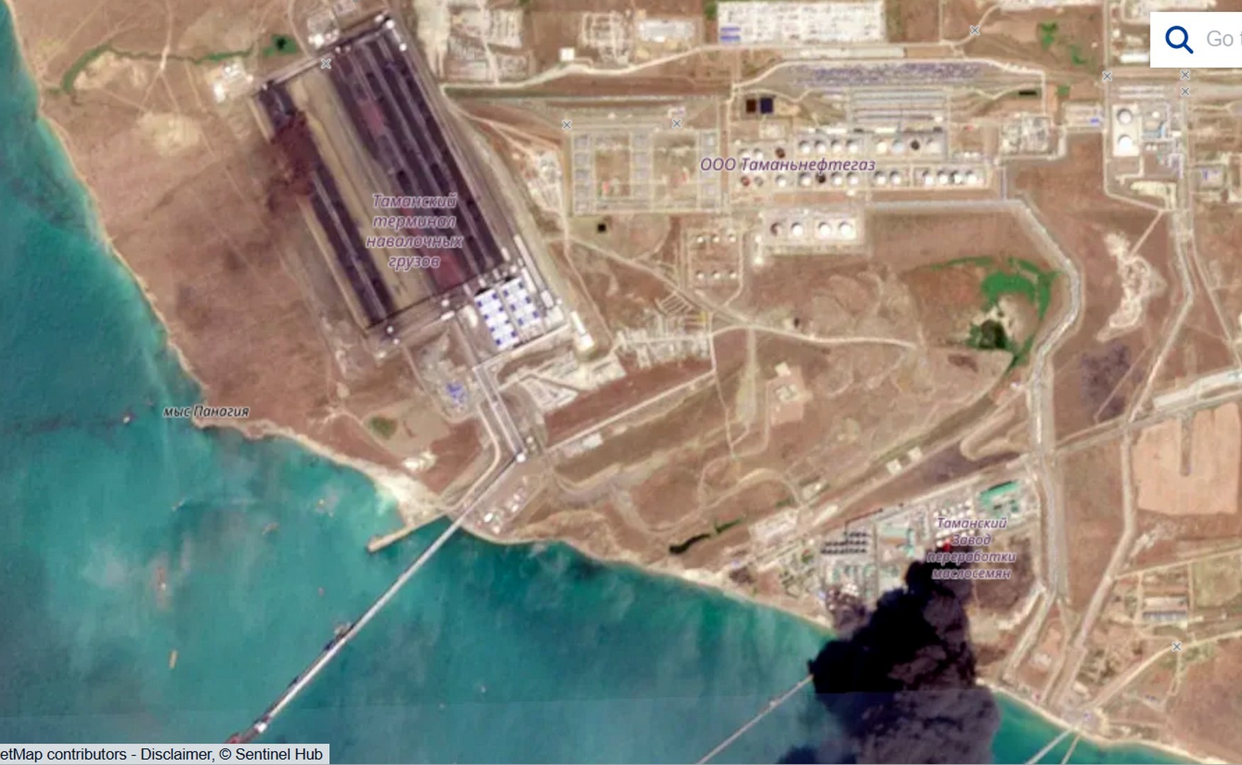
The grain framing is not accidental: it lets Russia invoke global food security and court international outrage. In this case, however, the substance is fuel, and that can be shown step by step.
Smoke does not lie: fuel that burned without pause
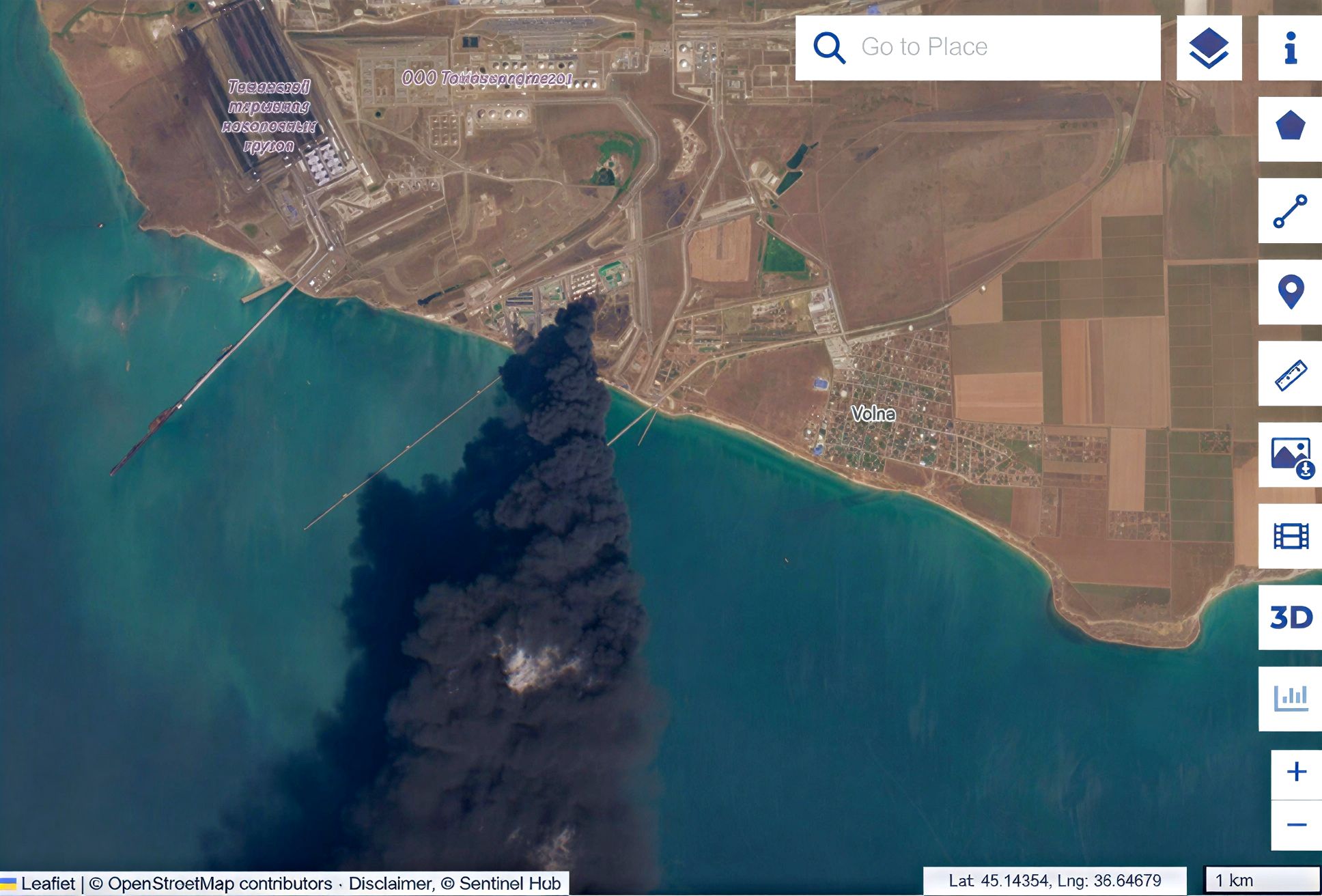
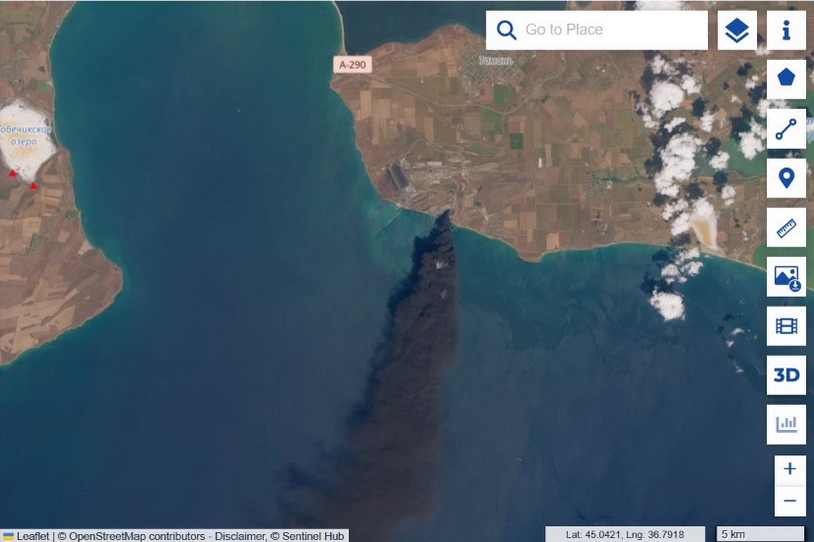
The Sentinel-2 optical image shows a dense, uniformly black, oily smoke column carried out to sea, with a visible plume length of roughly 100 kilometres on the 31 July frame by our own measurement. From there it is a matter of elimination. Vegetable oil does not ignite from a strike: its flash point exceeds 300 °C, and the smoke would in any case be pale. Hexane, the solvent used in oil extraction, flares black but burns off in minutes, whereas this fire ran for days. Biomass such as husk and meal burns unevenly, with a pale margin, not as an even black column. Once all three are ruled out, what remains is a steady, black, multi-day fire, and that is the signature of a stable hydrocarbon.
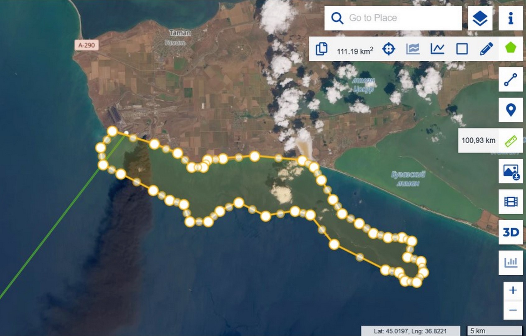
Oil does not burn: verified across eight cases
There is empirical support as well. «Zeleniy Lyst» has systematically documented strikes on oil infrastructure, and over two years there have been at least eight hits on vegetable-oil tanks in the ports of Pivdennyi and Chornomorsk. In none of them did the oil sustain a lasting black flame: it leaked, spread as a film, occasionally set nearby structures alight, but never produced an oily black column lasting days. We compiled the comparison in our satellite analysis of Operation Molochka.
Thermal signal: a fire that did not go out
FIRMS records heat independently of smoke, and the picture from 28 July to 4 August is unambiguous. On 28 July it is clear, the pre-strike baseline. On the 29th isolated background detections appear, and on the 30th a dense cluster flares on the day of the strike. From 31 July through 2 August the signal holds at full strength; on 3 August the periphery burns down but the hotspot at the facility itself does not disappear, and on the 4th fresh detections appear around it. The essential point is that the plant’s own location burned without interruption throughout.
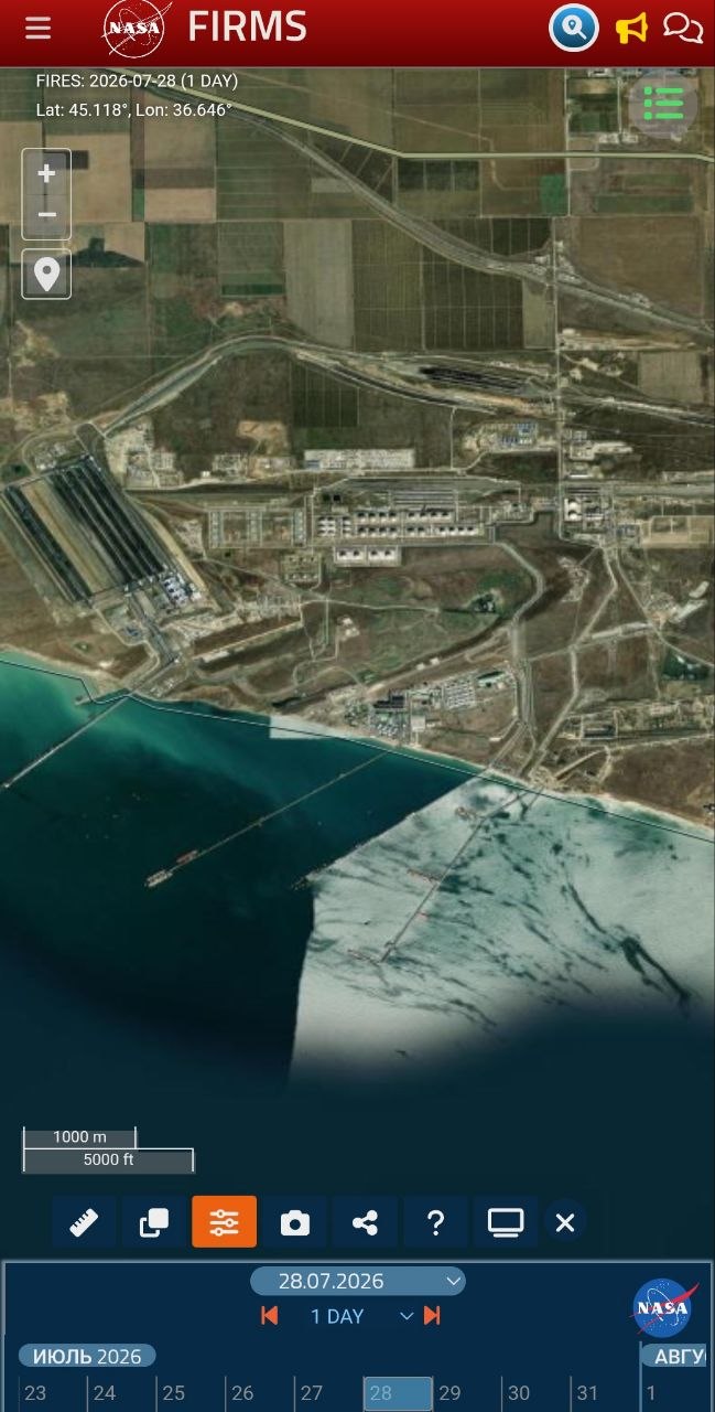
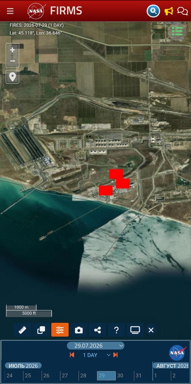
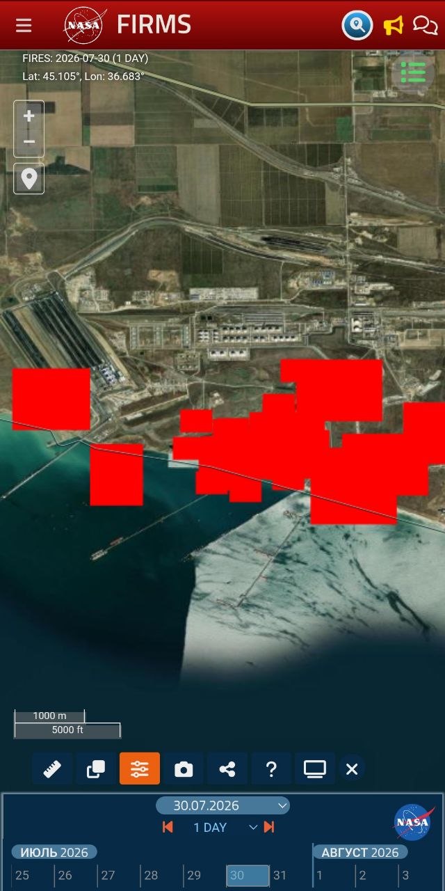
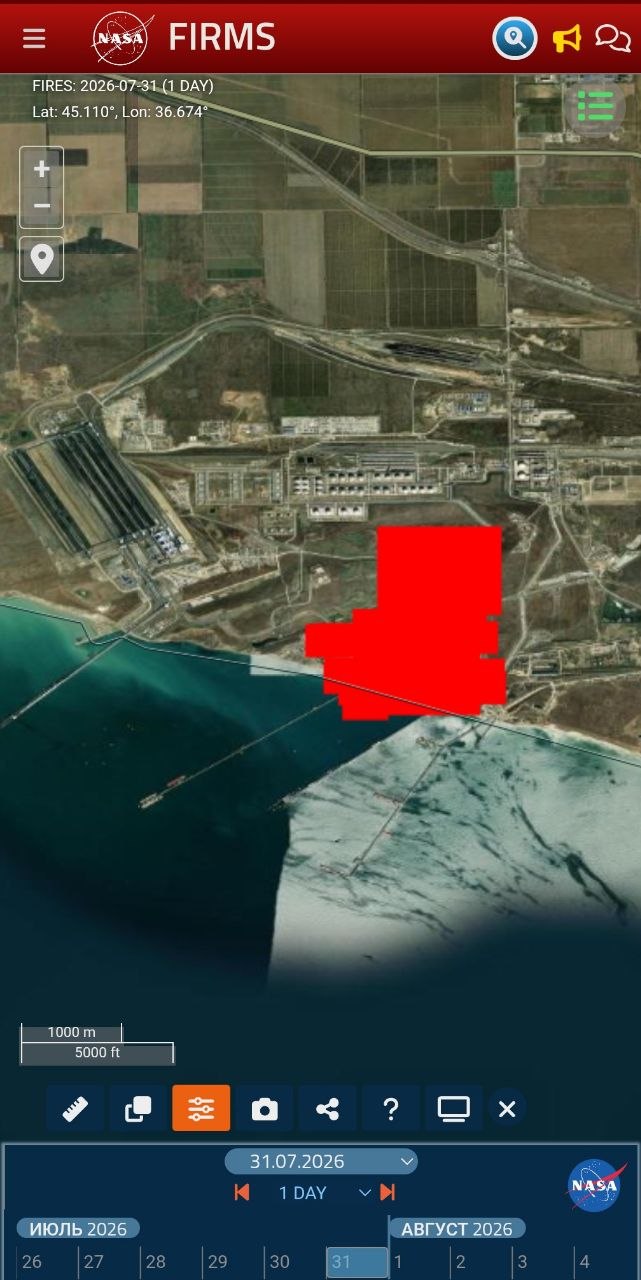
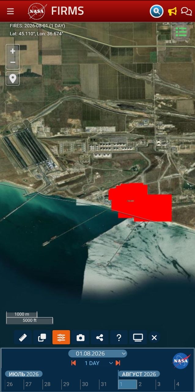
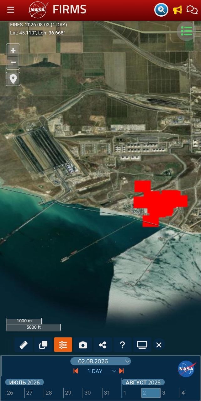
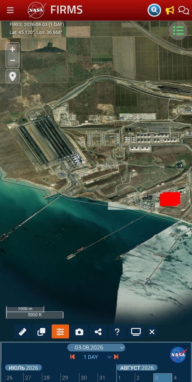
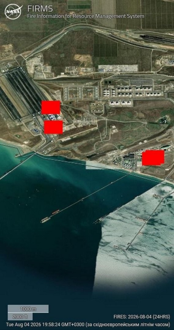
Vegetable oil does not burn for six days. Hexane burns off in minutes. Meal does not radiate heat like this. This is fuel, and it kept burning.
A civilian label on a military node
When a site is listed on every map as an oilseed processing plant, yet its hotspot burns without pause for six days and throws a hundred-kilometre black plume, this is no longer coincidence but tactic. Military logistics are hidden behind a civilian label so that a strike can be recast as a hit on “civilian infrastructure” or “on grain.” Two readings are possible and both point the same way: either the occupiers kept fuel under the guise of a civilian enterprise, using it as a shield, or it genuinely was an oil mill into which petroleum was piped for army needs. Either way this is the deliberate use of a civilian object for military purposes, itself a breach of international humanitarian law by the party that does it.
The cause should be named plainly. Russia is waging a war of destruction against Ukraine, and Ukraine, in defending itself, is entitled to strike the adversary’s military-logistics objects. The aggressor state has deliberately turned occupied Crimea and the Taman shore into a military-logistics complex, a fuel-supply node for the offensive, and placed it on the shore of a semi-enclosed sea, without secondary containment or visible safety measures, under civilian labels. Such a node carries a dual threat, military because it feeds the front and environmental because any damage to it sends product straight into the water, and responsibility for the environmental consequences rests with the side that built it this way and in this place.
Contamination on the water: spill dynamics
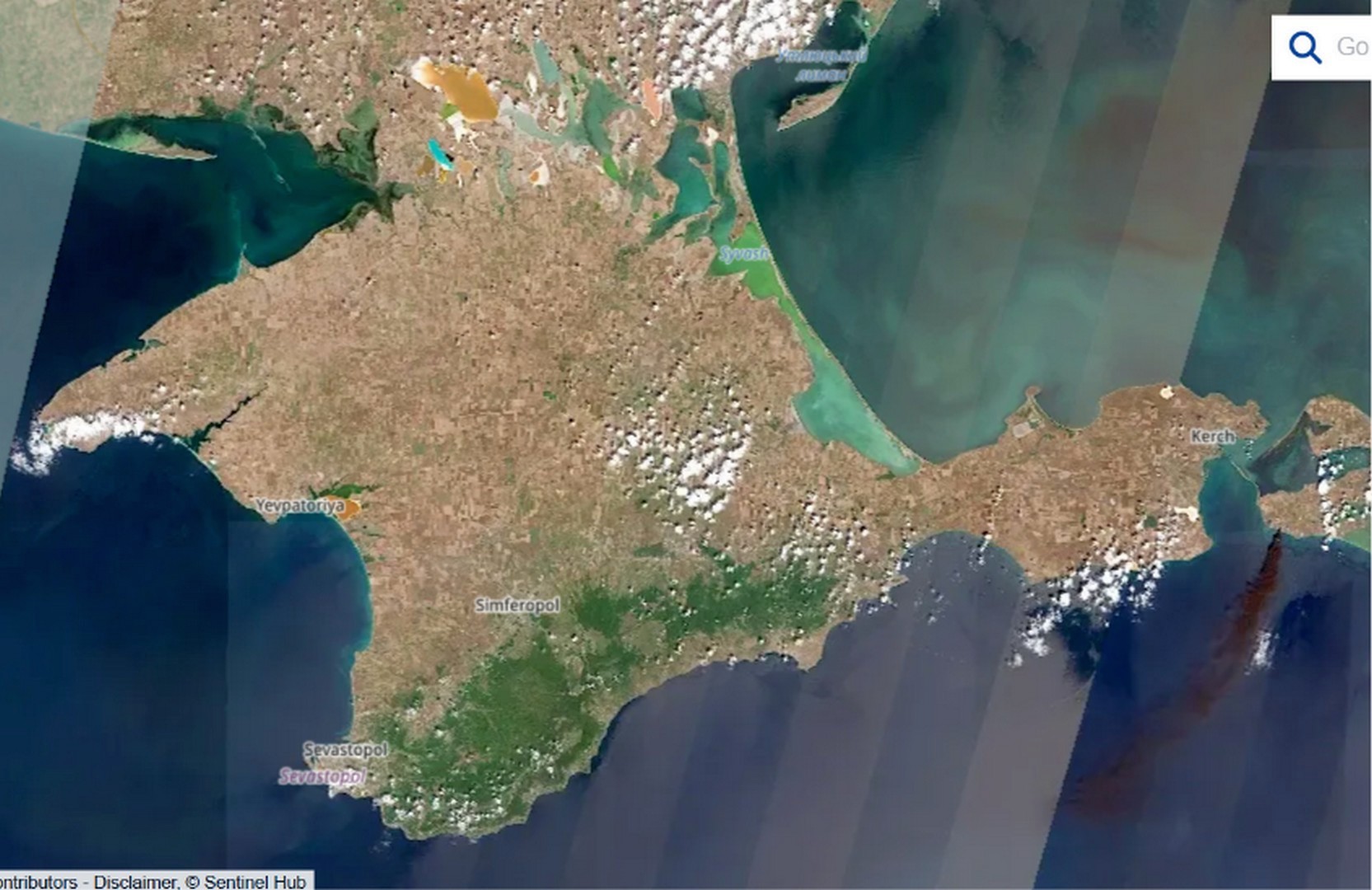
While Russian media spoke of grain and oil, the satellites were recording the actual slick, and doing so in two different ways. On the very first day the Sentinel-2 optical image of 31 July, captured under sun glint that reveals the film’s surface smoothing, allowed the early contamination to be outlined by polygon, yielding a bounding area of about 111 square kilometres. That figure must be read correctly: it is the area of the envelope, not a continuous film, because within it the product is scattered as separate fingers and streaks, and only a fraction of the water is actually covered. The slick was then tracked by Sentinel-1 radar, which detects the dampening of small waves even through cloud: on 1 August a compact plume 18.91 km long south of Taman, and on 4 August a tongue stretched to 40.44 km with vortex structures at the current boundary. The transport rate is roughly 7–8 kilometres per day, and the source was not a one-off, since fresh FIRMS hotspots on 4 August show that inflows continued.
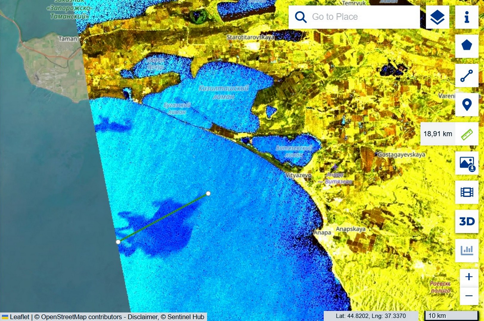
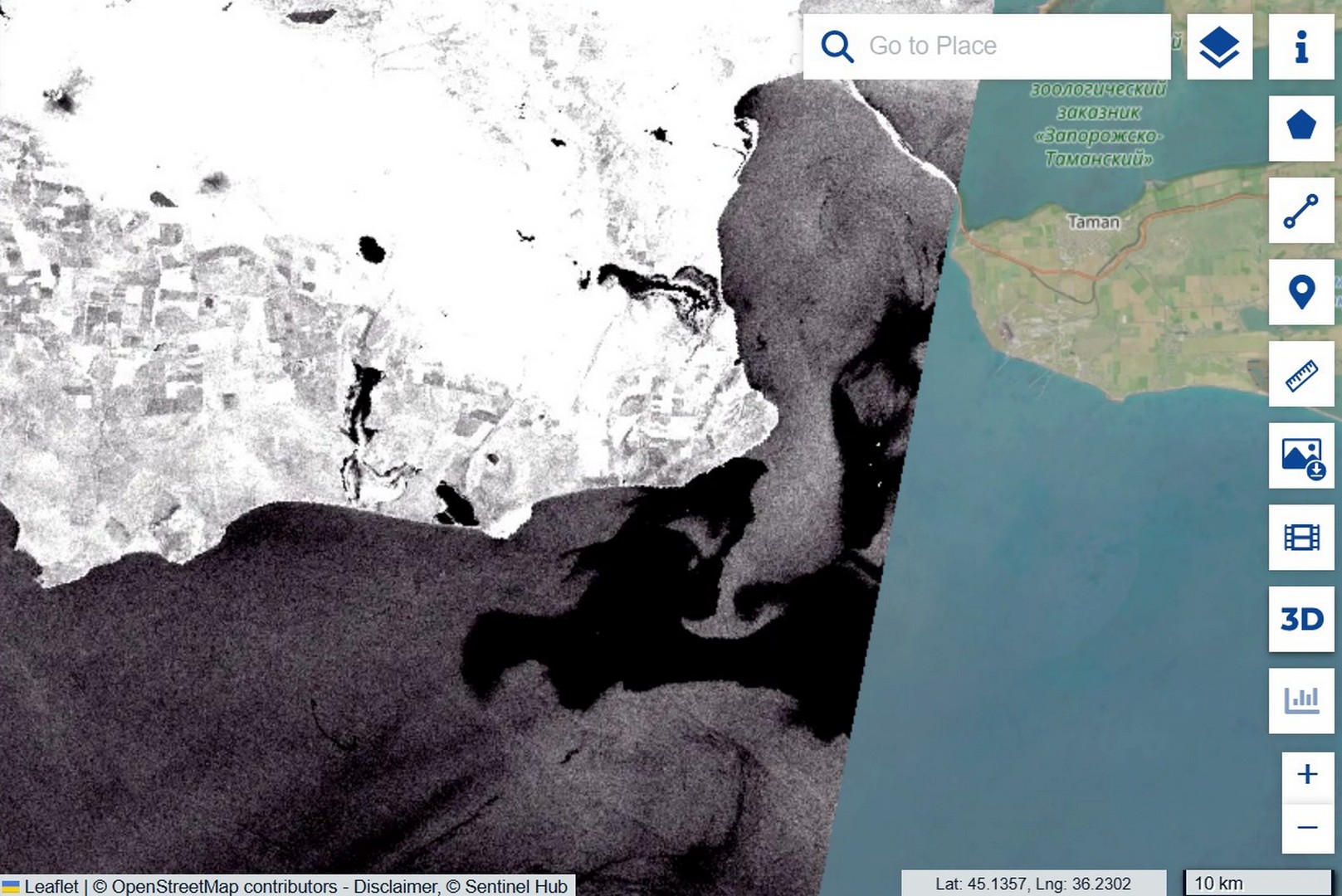
Movement forecast: from Anapa to the Kerch peninsula
From 30 July to 2 August a north-easterly wind of 5–14 metres per second drove the film south-west, towards the coast of Anapa, and on 4 August it swung southerly and eased to 2–4 metres, so the outflow to open sea stopped and the contamination began to be drawn back towards the mouth of the strait. For the shorelines this means that at Anapa the risk persists on the shallows while new inflows cease, whereas the main threat shifts to the western shore of the Kerch peninsula, towards Kerch and on to Feodosia, where a weak southerly wind will draw the film. The exact heading beyond two or three days is hard to predict, because under a weak synoptic background the sea-breeze cycle takes over, onshore by day and offshore by night.
Update 5–8 August: the forecast held, and oil surfaced on the water
A few days after first publication new Sentinel-2 frames became available, confirming two of our conclusions and substantially strengthening a third. The drift forecast held: we wrote that once the wind reversed the contamination would be drawn along the western shore of the peninsula towards Feodosia, and that is what happened. On the 5 August image the slick is recorded along the southern shore, near the Opuk reserve and the Feodosia gulf, and on the 8 August frame the total transport length from Taman reaches 75.93 kilometres, against 40 four days earlier. The slick did not dissipate; it stretched along the coast exactly along the predicted scenario.
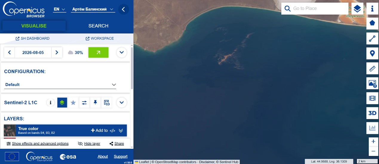
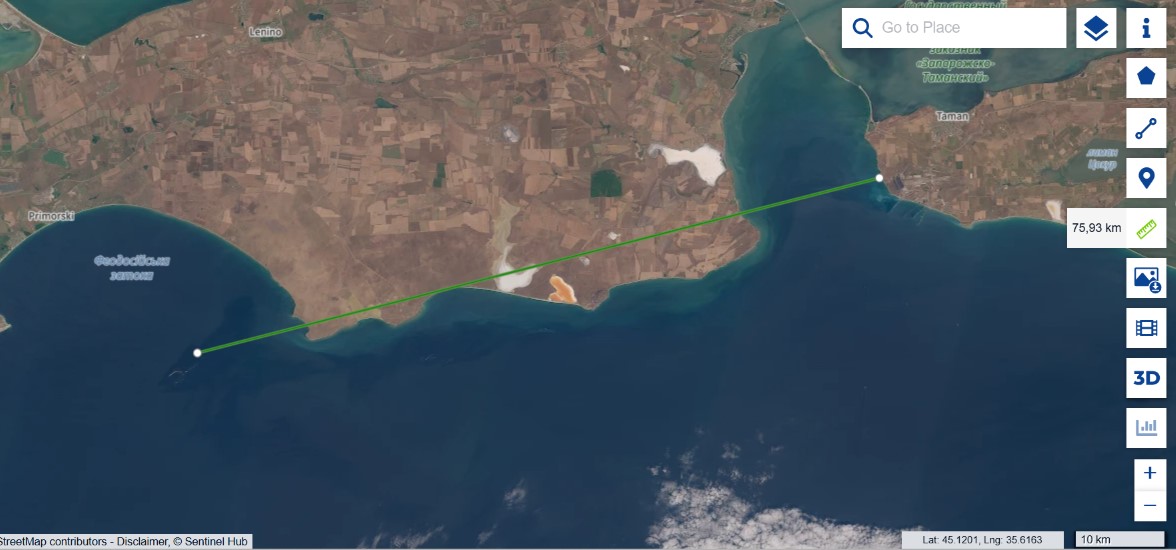
The decisive point, however, is the nature of the light-coloured contamination. Along the shore a dense, form-holding yellowish structure is visible, not a thin iridescent sheen but thick emulsified ridges, and that is a diagnostic feature. Light petroleum products have low viscosity, spread into a thin film within minutes and give a silvery-iridescent sheen, but do not form dense ridges, having nothing to hold structure with. Fuel oil and crude, by contrast, are dark, because a thick layer absorbs light. Vegetable oil is viscous and emulsifies under wave action, forming a dense light phase resembling yellow sour cream, so a dense yellow ridge matches neither light petroleum products nor fuel oil and points to a viscous, emulsifiable substance, most probably vegetable oil.
We have seen this same signature before. After the strike on Chornomorsk on 26 April 2026, where a confirmed sunflower-oil spill occurred, the water developed the same dense yellow emulsified structures, and the morphology matches.
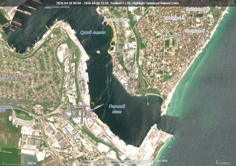
This is a morphological comparison of optical frames, not a spectral proof of substance identity, so “the same emulsified morphology, characteristic of vegetable oil” is a conclusion grounded in remote-sensing evidence rather than a substitute for laboratory confirmation.
What this means for the whole story is that the two accounts, the Russian one of oil and grain and the Ukrainian one of petroleum, stop being mutually exclusive, because the data show both, but separately, each by its own signature. Fuel burned, as the FIRMS heat and the black smoke attest, and alongside it, at a mixed terminal, there was oil that leaked on impact, did not burn as in the eight documented cases, and days later surfaced as light ridges along the coast. Not “either/or,” but “fuel burned and oil spilled,” with each component proven by its own independent signature.
What comes next. On the imagery the yellow emulsified ridge is effectively already within the Feodosia gulf, and the Feodosia shore is not far from there. The wind is carrying it precisely that way, so in the coming days the oil should appear along the Feodosia coast and adjacent stretches of the southern Crimean shore. This is no longer a distant forecast but a matter of a few kilometres and a few days.
Consequences for the marine environment
The facility sits on the shore, right at the waterline, without secondary containment or visible engineering barriers, so any damage to the tanks sends product straight into the sea. This occurs in a sensitive body of water: the Black Sea is anoxic below 150–200 metres, living benthos exists only on a narrow strip of shelf, and additional loading presses it against the hydrogen-sulphide boundary. The area’s benthic filter feeders, mussels, polychaetes and small crustaceans, are also the forage base for commercial fish, so damage to the bottom propagates through the whole food chain.
Petroleum products and vegetable oil act differently, and this matters for assessing the consequences. Petroleum products carry carcinogenic toxicity through polycyclic aromatic hydrocarbons; part evaporates, the rest settles. Vegetable oil has no carcinogenic properties but behaves more insidiously: in summer, under ultraviolet light and in warm water, it polymerises, hardening into a dense benthic cap almost impermeable to oxygen. According to NOAA, such polymerised oil persists on the bottom for more than six years; without polymerisation it would biodegrade within half a year, but the Taman strike occurred at the height of summer, in conditions that guarantee polymerisation. Storm-driven resuspension returns the sediment to the water column season after season. For birds the oil is more dangerous than fuel oil, because it disrupts feather microstructure so that washing cannot restore it, and by our field observations after the December 2025 spill no more than five percent of the birds counted as rescued actually returned to the wild. A detailed treatment of these mechanisms, with references to the scientific literature and field data, is given in our report on the third oil spill in Odesa Bay.
The consequences are not local. Currents carry the contamination along the coast into the open Black Sea, where the cyclonic circulation spreads it over hundreds of kilometres, or northward through the strait into the shallow, spawning-ground Sea of Azov. Fuel oil from the Volgoneft wrecks in this same waters was recorded in the Tuzly Lagoons near Odesa, over 650 kilometres away, and every new accident is layered on the previous ones while the sea cannot process the load. Our field confirmations are compiled in the Tuzly Lagoons research and on the Environmental Evidence Platform.
In lieu of conclusions: what is established, what remains open
Established by direct observation and instruments: a continuous multi-day fire at the site from 30 July to 4 August (FIRMS); early film contamination of about 111 km² and a smoke plume of about 100 km (Sentinel-2); drift of the film from 19 to 40 km (Sentinel-1) and on to 76 km as of 8 August; that fuel burned rather than agricultural produce, along three independent lines; that the light contamination shows an emulsified morphology characteristic of vegetable oil, matching the reference spill at Chornomorsk; and that the drift forecast along the Kerch peninsula held.
What remains hypothesis is the specific fuel type and the reason for its presence at a civilian-labelled site, the exact area of continuous film since the satellite gives only the envelope, the trajectory beyond two or three days since current data are required, and the full extent of harm to biocenoses without field verification, because there is no access to the occupied shore.
Sources and data
- Sentinel-1, Sentinel-2 — ESA / Copernicus (Sentinel Hub).
- NASA FIRMS — thermal anomalies, 28 July — 8 August 2026.
- Surface weather observations, Opasne station; ECMWF forecast.
- Persistence of vegetable oil on the seabed — NOAA, Non-Petroleum Oil Spills.
- Methodology: DOI 10.20535/EHS2710-3315.2025.332100.
- Statements by the parties are given per official communications and require verification against primary sources.
Author: Vladyslav Balinskyi, editor-in-chief, «Zeleniy Lyst». Satellite data: ESA/Copernicus. Thermal data: NASA FIRMS. This is an analytical material; factual claims are kept separate from hypotheses.